| Type: | TR, 20 ft (6 m) |
| FA: | TR Ken Roberts + Karel Hrbacek |
| Page Views: | 704 total · 7/month |
| Shared By: | kenr on May 23, 2016 · Updates |
| Admins: | Morgan Patterson, SMarsh |
Your To-Do List:
Add To-Do ·
Use onX Backcountry to explore the terrain in 3D, view recent satellite imagery, and more. Now available in onX Backcountry Mobile apps! For more information see this post.
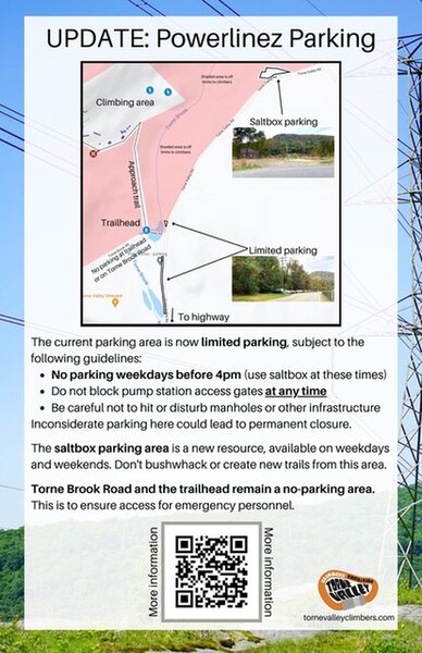
 Access Issue: As of November 2021, there are new parking arrangements. Please follow this guidance.
Details
The current parking area is now limited parking, subject to the following guidelines:
No parking weekdays before 4pm. (Use Saltbox Parking Area at these times).
Do not block pump station access gates at any time.
Be careful not to hit or disturb manholes or other infrastructure.
The Saltbox Parking Area is a new resource, available on weekdays and weekends. Don't bushwhack or create new trails from this area.
Torne Brook Road and the trailhead remain a no-parking area. This is to ensure access for emergency personnel.
Inconsiderate or illegal parking here could lead to permanent closure.
Description

Interesting moves -- too bad it's not longer.
Up the dihedral.
Warning: The rock on and around this route has not been climbed much yet, and much of the rock is still breakable and loose -- so the belayer and other people should stand far away from underneath the climber.
. . . (Lots of vegetation on this rock as of 2016. Be prepared when climbing to navigate around protruding trees and branches, and dealing with holds slippery with grass, lichen, moss, dirt).
Location

Near the left end of the Check Book wall, above a jumble of fallen rocks at the high point of the ground at the base of the sector -- are four dihedrals / open books. This route is right-most of those dihedrals.
--> See on these routes photos ...
--> See on these routes photos ...
Protection

For ideas to set up Top-Rope, see the Description of this Check Book sector .
Protection for Trad leading is unknown.
Protection for Trad leading is unknown.

 Continue with onX Maps
 Sign in with Facebook


0 Comments