Southeast Face of Nelion

5.8 YDS 5b French 16 Ewbanks VI- UIAA 15 ZA HVS 4c British


 Avg: 3.6 from 14
votes
| Type: | Trad, Alpine, 1200 ft (364 m), 20 pitches, Grade IV |
| FA: | E. E. Shipton and P. W. Harris, Jan 6, 1929 |
| Page Views: | 19,660 total · 132/month |
| Shared By: | Ken Trout on Feb 9, 2013 |
| Admins: | Big Red |
Your To-Do List:
Add To-Do ·
Your Star Rating:


Use onX Backcountry to explore the terrain in 3D, view recent satellite imagery, and more. Now available in onX Backcountry Mobile apps! For more information see this post.
The Classic Rock Climb of the Southern Hemisphere

When it's winter up north, this is a 15 pitch rock climb that can be done with a small rack, single 60m rope, and rock shoes (or boots). Lots of novices have been guided up Nelion, even though it takes thirteen rappels to get down (25m raps). January and February are the driest months. The rains might stop by December for Christmas holidays.
Be aware: even in the thick of summer, conditions can vary wildly. Weather is unpredictable and what starts as a perfectly clear day can quickly deteriorate to full-on conditions. Dry season DOES NOT guarantee no precipitation, so come prepared for weather and cold.
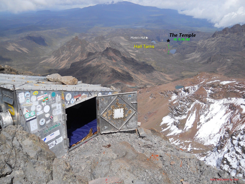
Once Nelion is climbed, continuing down to the Gate of Mists and up to Batian is more advanced and committing. There is a tiny hut at the summit of Point Nelion and some parties spend the night either before or after traversing to the summit of Batian.
From the summit of Nelion, downclimbing to the Gate of Mists requires one long rappel, found about half way down to the Gate. From the Gate, easy fifth class rock leads to the top of Batian (and adds on a few more rappels back down to the Gate). To ensure a safe return back up the fixed rope to Nelion, team members should have their own ascenders and know how to use them!
For reversing the route back up to Nelion, some have used ice gear to climb around left of the ice/snow patch by the rappel. However, it is much easier to travel in Africa with extra rope & ascenders than to carry ice boots, crampons, screws, and two ice tools.
A real route description follows, but first a few basics.
EQUATORIAL CONDITIONS
In the photo above, the Diamond Couloir is very dry and sunny in January. Even during July, August, or September, when the south side is coldest, the lower section never forms well anymore. Adapting to the change, ice climbers have dry-tooled the start (M7!). The couloir is now widely accepted as too dangerous due to rockfall.
No matter what time of year, the nights are twelve hours long and sunset is quick on the Equator.
GUIDES
There are many companies to recommend for the Naro Moru trekking route, here are two. Expect to commit by paying in advance.
The Naro Moru River Lodge has cooks, porters, climbing guides, equipment rental, safe lodging in a nice place, and a ride to the airport. They own the huts on this approach too. Other guided treks will make arrangements with the lodge. My family did not hire a climbing guide because we are a team, but we did have a trekking guide and porters. If we had changed our minds, then a guide could have been called up via cell phoned in from near MacKinder's Hut.
Savage Wilderness is operated by the man who made the only good map of Mount Kenya. I observed the operation of Savage Wilderness all over the mountain and they are excellent too.
Approach Nelion via the Naru Moru Trekking Route

While most hike the road from the park entrance, it is possible to hire a vehicle from local guides to drive up to Met Station Camp. Usually best to stay two nights at 10,000ft. Then, hike up to the hut at Mackinder's Camp (ca 14,000ft/4,000m).
On summit day, use the "Lewis Tarn Approach" up the west side of the Lewis Glacier (red on map below). This way is dry enough for trail running shoes and only requires a 3,000 ft elevation gain from the Mackinder Hut to the summit of Nelion.
Staying at the chilly Austrian Hut means crossing the ice of the Lewis Glacier to approach the Southeast Face and that requires mountaineering gear.
The map below shows the approach route from Mackinder's Camp to the regular route on Nelion (SE Face). From Lewis Tarn, climb up left to gain the slabs and ramps way above the glacier. The cairns get bigger and better as one gets closer to the start of the Southeast Face.
Route Description for Nelion's Southeast Face

The description below is for one of many variations to the route. For other descriptions, please get in touch with the Mountain Club of Kenya and find their official guidebook to Mount Kenya.
The first nine pitches are easily seen on the photo-topo above. Franco Pecchio's photo of the traverse to MacKinder's Chiminey shows how the route traverses past the obvious big chimney/corner. The rappels are even further to climber's right. It is a nice 5.10- top rope off the last rap' anchor.
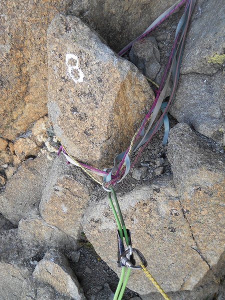
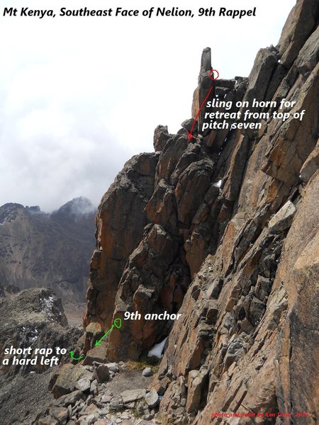
After the juggy roof of Mackinder's Chimney, it's fun and easy for several pitches up to the top of the Southeast Faces's knife-edge summit which must be crossed at rappel #7's single shiny rappel anchor.
The photo below shows the downclimb off the knifedge and easy traverse to the start of pitch ten. I guess that the bolt marked with red is to keep ropes off the loose blocks.
Pitch ten is easy 5th up to a single bolt (for the 6th rap anchor).
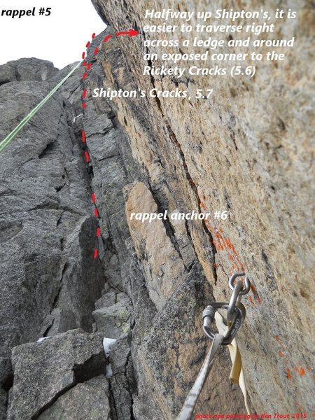
I chickened out on finishing up Shipton's Crack, but on the descent it looked no harder than my exposed traverse to Rickety Crack, where a cold wind blows on the arete. Both cracks end on a beautiful ridge at belay number twelve, marked on some photos. The pitch thirteen 5.7 traverse is harder than it looks...(see photo below)
There is an easier chimney just left, out of the photo and filled with an ice blob. Ian Allen's 1998, Mtn Club of Kenya, guide book rates it III (5.3). Cameron Burn's, 1998, Mountaineers, guide books give it IV (5.5). The chimney looked like a valid escape if the 5.9 layback proves to much.
DESCENT
In 2016/7 the single glue-ins were backed up with additional bolts.
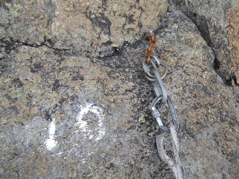
13 rappels down the Austrian bolt line (30 meters maximum). Green arrows for rappels and green x's for each rap anchor on the photo-topo.
The 3rd anchor is on a wildly exposed ledge. The 4th, 5th, and 6th are off single Austrian glue-ins.
After rappel #6, reverse the easy ledges down to bolts (red on photo) and then up the 4th class chimney to the top of the knife-edge ridge and the seventh anchor.
Oops on the "unclimbed" face. I meant to say "unfreeclimbed!

 Continue with onX Maps
 Sign in with Facebook








11 Comments