| Type: | Sport, 100 ft (30 m) |
| FA: | unknown |
| Page Views: | 6,711 total · 23/month |
| Shared By: | Jeff Lockyer on Aug 6, 2001 |
| Admins: | Leo Paik, John McNamee, Frances Fierst, Monty, Monomaniac, Tyler KC |
Your To-Do List:
Add To-Do ·
Use onX Backcountry to explore the terrain in 3D, view recent satellite imagery, and more. Now available in onX Backcountry Mobile apps! For more information see this post.
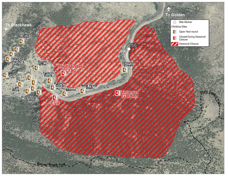
 Access Issue: Seasonal Raptor Closures
Details
Please be aware of the annual raptor seasonal closures!
Raptor Closures Effective February 1-July 31
Visit: jeffco.us/open-space/news/2…
Tunnel 1 closure
For more details visit: jeffco.us/open-space/alerts…
The two areas Jefferson County Open Space intends to close in Clear Creek Canyon, shown on the attached maps, encompass the active eagle nests. If the Clear Creek eagles continue to nest in the active nests, these areas will remain closed from February 1 through July 31. If the eagles choose different nesting sites, the closures will be adjusted accordingly to protect those eagles during their breeding season.
Currently, rock climbing areas that fall inside of the seasonal raptor closures include:
Blonde Formation
Bumbling Stock
Evil Area
Ghost Crag
Highlander
Skinny Legs
Stumbling Block
Tetanus Garden
Fault Caves
 Access Issue: Closure Notice - lifted
Details
Per Ondra Mahdal: the closure information is over 10 years old (I did call Martha to verify).
Previously, per CDOT/Daniel Dunn, BCC:
"Until further notice, the Cat Slab climbing area, located on the west side of Tunnel 5 immediately to the right if one is going downstream, will be closed for climbing. Clear Creek County Open Space has decided this closure is necessary for safety reasons with ongoing construction in the area. If you have any further questions please contact Martha Tableman at 303-679-2305."
After months of negotiation, Clear Creek County successfully acquired the 76-acre Oxbow Parcel that contains the Cat Slab cliff. While the cliff line is protected, the area is now officially open to the public. The County is working on developing and implementing a site plan to provide safe, off-road parking, which may include shifting the guard rail and gate to provide more parking as a short-term solution.
Cat Slab was a popular crag before it was closed to the public in 2006 due to liability concerns. The County purchased the land using $725,000 in lottery funds, awarded by Great Outdoors Colorado (GOCO). The County was supported by numerous recreational groups, including the Access Fund, Colorado Mountain Club, Colorado Whitewater, Trout Unlimited, International Mountain Bicycling Association, and Rafting Outfitters on Clear Creek.
Description

This is the 3rd route from the left side of the Catslab between "Old..." and "Rumple Teaser".
The route follows the left side of a black streak up the slab. The climbing is very enjoyable on this route. At the 5th/6th bolt, stick to the bolt line, don't head about 6 feet left or you will skip the best moves on the route, small crimps with small feet. I think the original line goes left to the quartz block. This variation may be 5.10b?
This is very enjoyable, like many of the routes at the Catslab. Enjoy!

 Continue with onX Maps
 Sign in with Facebook


![1. [[Skimbleshanks]]105749530, 8-.<br>
2. [[Old Deuteronomy]]105749185, 9.<br>
3. [[Mungajerry]]105752506, 9.<br>
4. [[Rumple Teaser]]105749188, 10-.<br>
5. [[Mr. Mistoffeles]], 9.<br>
6. [[Gumby Cat]]105748858, 4.<br>
7. [[Jellicle Cats]]105751141, 9.<br>
8. [[MacCavity]]105752512, 9.<br>
9. [[Grizabella]]105748861, 7.](https://mountainproject.com/assets/photos/climb/1301819_smallMed_1557850513.jpg?cache=1734372697)


19 Comments