
 Continue with onX Maps
 Sign in with Facebook


North Cascades conditions in June
|
|
Planning a trip out to the Pickets early-June, and was trying to get a read on conditions for the area, both the low-land hike in and up on the mountains. Heard the snowpack is low this year. I know this is far out in the future, so I'm just trying to get any sense of it for now. |
|
|
Following…. |

|
Check Washington DOT on the highway conditions. Would give you a good idea of where the current snow pack elevation is at. |

|
June is usually pretty early snowpack wise. |
|
|
Current snow-water equivalent is 62% of normal in north cascades. Site level detail IMO it’s probably as good a year as any to be planning to visit the Pickets in what may be considered a little off season. Generally you’d have two concerns during that time of year. The first that the weather just sucks. No guarantees there despite the NOAA climate prediction. Second concern would be an unstable, mushy snowpack as we move into summer. IMO that’s going to happen earlier this year but keep an eye on the possibility I’m wrong. Trails below 4000’ are going to melt out way early this year as there was hardly any snow below that elevation until quite recently. There’s maybe a more normal amount of snow above 6500’ or 7000’ but again I’d expect that to shed and stabilize earlier than normal.
|
|
|
Darin Berdinka wrote: Thanks for the good info! I'll keep an eye on those links as it gets closer. |
|
|
Here’s a link to Bellingham’s weather from last year. I’d say June is usually good, but sees some bad days. If it were me planning a trip out in advance, I’d pick the first half of July. But at the same time, if I was planning a traverse in June with optional technical climbing, I wouldn’t be too worried. I’d want to prep for a potential wet day though. |
|
|
You may have some difficulty with stream crossings in June. Get ready for some numbing cold water. |
|
|
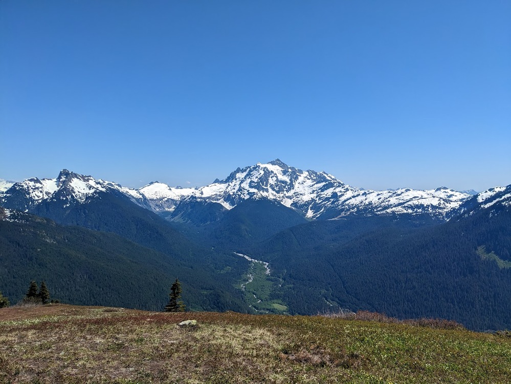 This is a picture from June 3rd 2023 in the general direction of the Pickets... Last year experienced an early melt as well. The hiking was beautiful and snow free below 4000', but it was fairly snowy around 5,500' where this picture was taken. I would expect to need crampons and axe above 5,000ft on N aspects, and would have appreciated extra socks and gaiters, as the snow was saturated. Good luck! |
|
|
Snow levels are super fickle and can change based on the whims of just a couple weeks weather. I have a big trip planned northeast of the Pickets (Pasaytan) leaving June 2; and have been working on snowpack prediction. I have a decent excel shell on my work computer I could send you - you’d just have to replace the snotel data with sites closer to your destination; mine are all near WA Pass which isn’t totally off but you might have better results using closer sites if there are any. Or the short answer if you just want to take my results; looking at averaging out the last 20 years of data for June 1st and applying a logarithmic model for snow depth vs. elevation and then assuming the current trends in snow water equivalent my projections showed aspect and shade dependent snow line starting around 4300ft and a more consistent presence of snow starting around 5300ft; but there will still be huge variances dependent upon aspect and slope angle relative to sun exposure. The typical SNOTEL site is on a 10-20 degree slope and exposed to the open air; I assumed the consistent snow line being where a typical SNOTEL site terrain would read 24” depth. You could expect much shallower on steeper south facing slopes and a bit more in shallow pockets on north facing slopes. |


