
 Continue with onX Maps
 Sign in with Facebook


Clear Creek Canyon Bike Path


|
|
Now that the easy to build portions of the bike path in Clear Creek Canyon have been completed, construction will move on to the more difficult portions. It appears that the general approach will be to literally build a bridge through, or along the creek running up all the parts of the canyon enclosed by cliffs, or where the highway occupies the easy terrain. It would seem unlikely that this won't significantly impact many of the best crags with either temporary or permanent closure. It is conceivable that some cags that are now hard to get to will perhaps be easier to get to after bridges are built. Also, parking could be affected, especially around the Tunnel 2 and 3 in areas that already have limited parking. The climbing community should keep a very close eye on this project. What is also very concerning is the extreme cost of this project, $273,000,000 for just the Jefferson County portion alone. Spending this much money on a bike path is an egregious waste of taxpayer dollars. To put this in perspective, the realignment of I70 at Floyd Hill nearby, a major transportation for the entire country is only $700 million, about twice the cost for this bike path. The decision to build this bike path trough a narrow, cliff lined canyon that already has a highway in it is an engineering failure. Just about anywhere else would've been better, like through Centennial Cone Park or long US40 on sunny hillsides, which would cost a fraction of the $273,000,000 to build and be usable more months of the year. Also, this heavy construction will likely damage what remains of the creek bed and create dangers for paddlers too. Maybe it would be better to just terminate this project now and and find something better to do with that much money. |
|
|
always with the negative waves Moriarty, others would call it an engineering marvel. it's a done deal, vail to golden |

|
From a rec standpoint, I'm happy for the path. It'll open up some great bike connections as CCC is a major barrier for bike rambling. Parking has been vastly improved in some locations too, which may help with crag access. The economics of it I'm sure are studied, but I'd find it hard to believe this doesn't translate directly into revenue for Golden businesses. |
|
|
TZ-- So far, much of the $$$ for trail construction has come as grants from Great Outdoors Colorado and Colorado Parks and Wildlife, Jefferson County Parks, etc. Gamblers, fishermen, and duck hunters have been paying for the path...That will probably continue as a major funding source in the future, so unless you're buying lottery tix, perhaps spending your paycheck in Blackhawk, or buying a hunting or fishing license, you're just not being dunned for the canyon pathway. It's a nice new feature in that canyon. Plenty o' folks don't climb, but want better access for biking, walking, fishing, etc. If you can access climbing a bit easier, like up at Tunnel Five, well, it's just a bonus. You sounds like the guy that was complaining a few years ago about the semi-trucks using their jake brakes in the canyon, disturbing his belaying... |
|
|
Most of the money will come from sales tax paid for by the everything that you buy in Jefferson County. Even if was from GOCO money it’s still a tax stolen from someone. $273 million could build a nice bike path network used for people to get around town, something useful. Or maybe just give the people back their money. |
|
|
This is outrageous! We could build 27 abrams tanks for that! Seriously, of all the money the various governments collect from us, a bike path seems like a relatively rad use of the money. I haven't kept up on this project because It's not in my immediate neighborhood, but is it possible that there are public comment periods and/or community engagement meetings that concerned citizens like yourself could participate in and voice your concerns? It's possible that they might share their plans/methods/results for evaluating environmental impact on the creek bed. That might assuage your concerns. As for the paddlers, boaters are weird so who cares? (just kidding). Also, to be clear I realize jeffco taxes don't pay for tanks. Just sayin. But if you're that worried about misappropriation of tax funds, you could always stop paying your taxes. That'd show em. |

|
Tzilla Rapdrilla wrote: I think its actually the opposite right? It would be an engineering feat to build this path through a narrow canyon. I agree that its a lot of money although I am not an expert on how much a bike path should cost. Government spending is always wack but I dont think they'll be back tracking on this. I'm pretty stoked for it. Being able to walk/ ride up the canyon will be sweet. It will bring more revenue to businesses and more people to the area (yes, it goes against the general NIMBY attitude that the residents of Golden have). |
|
|
Tzilla Rapdrilla wrote: GOCO money is derived from lottery proceeds, and the interest on the proceeds. Gamblers pay for recreation opportunities for everyone else, which is fine for me. Don't wanna pay for the CCC path? Don't buy a lottery ticket. https://goco.org/about/our-finances#:~:text=Great%20Outdoors%20Colorado%20revenues%20are%20primarily%20from%20lottery%20proceeds%20and%20interest%20income. |
|
|
Of the $273 million for the 12 miles of bike path only $13.8 million comes from GOCO, $227.5 million comes from JCOS (Jeffco taxpayers), the rest comes from CDOT & DRCOG. The vast majority of the cost comes from county taxpayers, while the County Commissioners are claiming that there is a budget shortfall and need to raise taxes. I would suggest that a ballot initiative be proposed for a special climbing tax, because, well climbing is unsafe and too risky. For crissakes, get down from there! This new tax would be 1000% on all climbing gear, gym memberships, etc. A massive fee, not called a tax mind you, would be levied on any outdoor climbing in Colorado. This money could then be used to pay for something virtuous like building special bike trails everywhere, protecting cyclists from the hazards associated with riding on the road. This would keep climbers from excessively using precious health care resources and provide for much safer cycling opportunity, something very good for the community. Since climbers are a minority of voters, "we" can vote to tax them and use the money for something really good. After all this worked with the morally bankrupt school lunch tax, just pick on a small enough group and take their money. So where will this bike path go between River Wall and High Wire/Wall of Justice? It's going to have to go along one or the other cliffs or in the creek. What routes and crags will get closed here?? Lots of other spots that will affect climbing areas besides there. The bike path could've been routed on the sunny north side of the canyon, but that part of JCOS is closed in part of the winter for elk and deer sex, and then again in the fall to kill the excess elk and deer. Don't want to put it there and save $250 million when you have an infinite amount of money to waste. Oh, it is a government project so $273 million is probably just a lowball early estimate that will be grossly overrun. |
|
|
Tzilla Rapdrilla wrote: Can you provide a link to these cost breakdowns? I cannot find anything when I google clear creek bike path costs |
|
|
Nolan Nolan wrote: 99% of "statistics" are made up on the spot. |
|
|
Y'all got any sources? I see lots of claims and zero official information |
|
|
[EDITED to update after Dan D comment with attached maps downthread] FWIW, some of the planning documents for the next section of the trail (from Huntsman Gulch to the west side of Tunnel 2, so the section that will affect Eiger Wall through Mission Wall or so) indicate that the intention is to route the trail: 1. next to the road on its south side below Eiger Wall, so well downhill of that crag (but probably crossing the start of [and therefore changing the configuration of] the current access trail) 2. through the existing culvert at the Mickey's ice climbing spot to the north side of the road 2. across the creek right before River Wall (near where the road crosses on the bridge that goes into Tunnel 2) and around the oxbow near the water level down below High Wire (affecting Low Wire?), then back across the creek on a second bridge just past River Wall (approximately above Higher Wire?) (see Dan's attached map below) 3. along the old railroad bed (now mostly a fishing access trail) on the outside of the oxbow around Tunnel 2, so therefore downhill of Irok, Punk Rock, etc. The existing crag that would be closest to the trail (right on it) in that section is Wannabe Wall. 4. below Mission Wall on that same old railroad bed (but with a parking lot and connecting bridge below Wall of the 90s) and then around the Tunnel 3 oxbow on that same (south) side of the river (so across the creek from Capitalist Crag) So, while it's true this next segment of the build in the JeffCo part of the canyon affects the highest concentration of major existing climbing crags, to my eye the place where the trail itself is likely to significantly impact a major crag is at the base of High Wire. Secondarily, it will also come close to the base of Mission Wall, but the strip of land between that cliff and the edge of the creek is wide enough for the trail plus a little bit more open land / belay area than, say the base of Fiscal cliff, where you're practically belaying on the paved trail. The next crag up canyon that stands to be affected is Anarchy Wall, which would get a new parking lot and trailhead below it. The parking at Wall of the 90s (as well as the crag itself) would be across the creek from the trail. The current design document calls for a trailhead and additional parking there, with a footbridge to connect to the trail on the opposite bank. At Tunnel 3, there is a trailhead and parking (35-40 spots) proposed under Anarchy Wall, but the trail itself would still be on the far side of the creek until a bridge several hundred yards upstream of Anarchy (so, the trailhead parking would be on the north side of the creek by the road, and then people would walk upstream a bit to where the Trail would come over to that side on a bridge and then stay on the north side of the creek [next to the road again] all the way to the Big Easy Trailhead up canyon. In general, parking could be affected for sure, but the intention appears to be to retain as much legal pull-off parking as possible while building more parking at the major trailhead points along the creek. It's possible there will be a loss of some parking spots near the base of some crags now, but there's supposed to be a net gain in total parking. I think it's very possible that more of us will begin parking at further-away trailheads in other segments of the canyon or even at the canyon mouth and then biking / walking to our crags. I've nudged the idea of bike racks below the major crags, and JeffCo seems to agree. No doubt the trail will change some aspects of climbing in the canyon (and already has), but I agree with some others up thread that 1) not all those changes are a loss of quality (in fact, few are, while some are gains), and 2) the momentum to share the canyon with a much larger and wider set of recreation users has long been rolling anyway, and while the P2P Trail accelerates that, climbers would be contending with changes at several of these locations in a piecemeal fashion even without the Trail. The P2P concept has been in the works for longer than a quarter century, and though the cost is huge (especially given the significant engineering challenges), it has had political support from several significant members of Congress and Colorado politicians over the years, and that has kept it going and facilitated much of the funding. At this stage, I would have a hard time imagining it being halted, even if a lot of us wanted to, which doesn't appear to be a universally-held opinion. |
|
|
I got annoyed by folks not linking sources and found some maps of the proposal EDIT: it actually looks like High Wire and the crags right below it may be more affected than River wall, though the document does say "[this section of the trail] will be sensitively placed..." 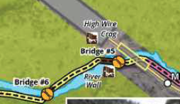 |
|
|
Dan D wrote: Thanks Dan, from your link it looks like $270m has been invested over the lifetime of the project, not for this last section. With $88m being for land acquisitions alone. |
|
|
Dan D wrote: Whoa-- thanks for this, Dan. My information was coming from an older feasibility study shared by JeffCo Open Space, which proposed not having the trail cross to the High Wire side of the creek at all near Tunnel 2. But this DRCOG document appears to be much more recent, so ostensibly it would be more accurate to the current proposed routing. I will edit my post above to correct the apparent discrepancies. According to these maps, the two big changes to the earlier proposed routing are a bridge across to the High Wire side of the creek at the east side of Tunnel 2, and a trailhead and parking area below Wall of the 90s, not just one below Anarchy Wall at Tunnel 3. Huh. |
|
|
Josh wrote: Yeah, no problem! It was actually kinda hard to find these maps. I could find some planning docs that REFERENCED the maps but finding the maps themselves took a bit more effort than I expected! |
|
|
Tzilla Rapdrilla wrote: Does it help that almost the entire $273M will be paid to private interests? I don’t have a strong opinion on the trail. I learned that lesson on here a few years ago. |
|
|
the next phase of the argument…‘I paid $273mm for this trail, you can’t do what you want to do on my trail.’ |
|
|
Live Perched wrote: YO! GOOD POINT! I WANT ONE OF MY FUCKIN ABRAMS! |
|
|
$273,000,000 would be enough to buy every MP user dozens of rifles, pistols, knives, enormous amounts of ammunition, bulletproof vests, smoke grenades, a year's worth of canned and freeze-dried foods, and a survival bunker. |


