
 Continue with onX Maps
 Sign in with Facebook


Access issue on lower Sullivan canyon?
|
|
We tried and failed to go to lower Sullivan canyon today. After turning right off of sweet valley road the road was blocked with these freshly installed fence posts. We drove around a bit but couldn't find a passable way around them. Do any locals know what's up? 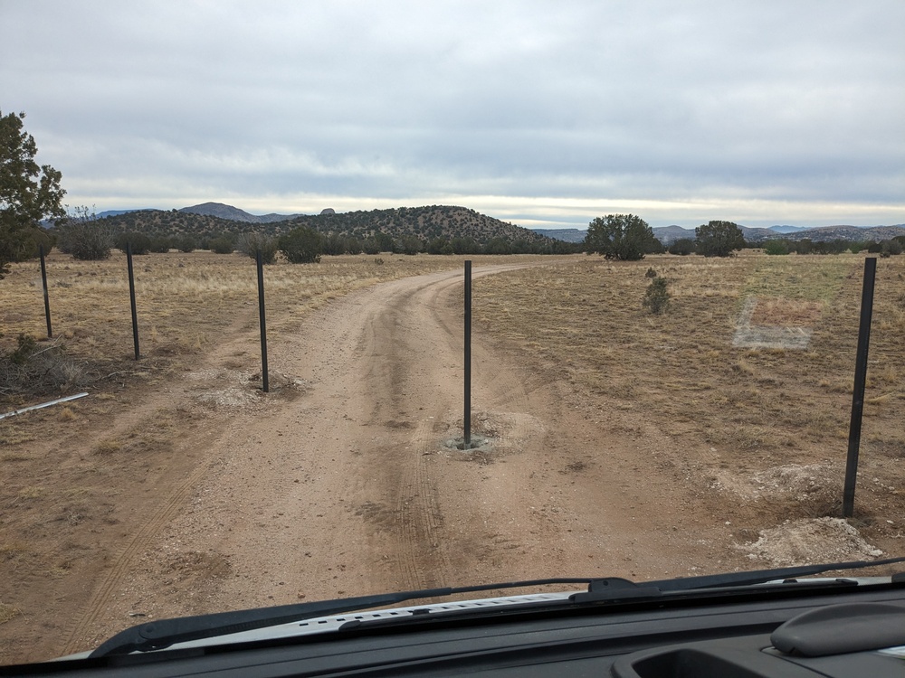 |
|
|
I'm not local to Paulden but my guess is someone who lives in the area got tired of people being back there. It is a mix of Arizona State Land Trust and private land back there. So blocking access to it is a crappy thing to do and probably not legal. Arizona State Trust Land is not public land in the way the forest service or BLM land is, but the only difference is that you need to have an individual recreation permit which is $15 and then: "The Permittee(s) acknowledge that recreation on State Trust land must only be conducted on lands that are open for recreation. Lands leased for agriculture, mining, commercial, or military purposes are not open to recreational use. Other State Trust lands may be closed to some or all recreational uses in coordination with other land management agencies. Permittee(s) is responsible for being aware of and complying with State Trust land closures. For more information on State Trust land closures, please click here ( gis.azland.gov/webapps/parcel/) or call 602-542-4631." If you look at the AZ State Land Trust map you'll see the vast majority of AZ state trust land is leased for grazing which to my understanding makes it fair game to recreate on as long as you have a permit and follow the guidelines. Having lived in parts of AZ with lots of state trust land I can tell you that it is not uncommon for people who live near the state trust land or lease to block access to it even though they are not supposed to. If you look at the AZ state Land Trust map you can actually see the one of the parcels closest to the climbing at Lower Sullivan's is currently unleased. Perhaps we climbers could lease it and then have an even more legitimate claim to recreate back there. Also just a heads up this is not the only area that people climb that is AZ State Trust Land that you need a permit to recreate on. Off the top of my head The Promised Land and Lower Devil's Canyon are both also State Trust Land so you should have a permit access that land. |


|
Hey Alexandre and Jake, This is really interesting, and "the locals" aren't really sure what's going on here, so thanks for sharing this update for access to Lower Sullivan's. Here is a snapshot of parcel data for the area that you say you found these posts: 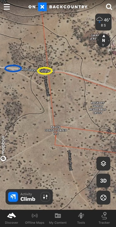 Were you at the "blue" or "yellow" circled location, or another location? And/or were both locations now blocked? At this time there is also a potential land sale taking place for Upper Sullivan's Canyon, and the Prescott Climbers Coalition is working with the Access Fund and the Trust for Public Land to try and secure climbing in that area. More to come on that and please reach out if you would like to get involved in the PCC. Thanks! Mac |
|
|
Thread needs GPS coordinates |
|
|
Sorry for the lack of coordinates! The photo was taken on google.com/maps?q=loc:34.87… which is neither the blue nor yellow circle here but around where the red line crosses the "private road" turning south off of sweet valley road Maybe I got the approach beta wrong! I was trying to get to https://maps.app.goo.gl/NC553jmqVx2MQZo87 which is where I thought we were supposed to park near the canyon. Happy to be involved in the PCC. I live in sedona but climb often near prescott. |
|
|
You have the right beta for Lower Sullivan's, Alexandre! The coordinate you provided of the fence post location does not line up with where the road crosses into the "Raven Consolidated, LLC" property. it looks well before it, which is more troubling. If you have an iPhone, it may have the exact location of this photo geo-stamped on it; or we can get out there and get a exact coordinates of the new fence line/road intersection. Hopefully this is just where the fence line actually is, and the road just needs to be re-routed around it. |
|
|
That location of the photo came from my android phone so it's a pretty precise gps drop (I had signal and everything) |
|
|
Ah, well that is definitely problematic since it doesn't even follow the property lines out there... We'll look into this more! For now, here is a bit of light reading: "Section R12-4-110 - Posting and Access to State Land" In short, I believe that the fence can only be there (for maximum of 30 days) if someone has leased the State Land, and wants to prevent "...the taking of wildlife will cause unreasonable interference during a critical livestock or commercial operation." See image below that shows the leased boundary is closer to the GPS point of the fence line. All of this is in line with Jake's comment above. I'm no attorney though! 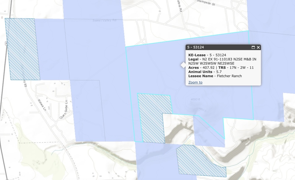 (Image of leased area, south of Sweet Valley Rd and north of Lower Sullivan's Canyon) |
|
|
UPDATE 1: From AZ State Land Department, after reporting this situation: "We've been able to verify, through an in-person inspection, that the fence in question is being built on a property line between State Trust land and private property by the private property owner. This would not fall within the jurisdiction of the State Land Department." I will continue looking into this and see what our best course of action is moving forward for access to Lower Sullivan's Canyon; and then post another update when I have it. |
|
|
UPDATE 2: From AZ State Land Department, after asking for truth data on property lines in the area: "The point you sent did pull up in GIS on State Trust land, however, when in the field our staff indicated the fence was right on the boundary of a corner of private land. Additionally, the private property owner verified they had a professional land survey conducted prior to beginning construction. On occasion the layers are not always perfectly precise on the basemaps" I attached a CalTopo screenshot of this location, and you can see how close the property corner is to the road. Assuming the surveyor did their job correctly, the private land owner I guess owns part of the road, according to the AZ State Land response. Therefore, we will need to find new access around this new fence to go to Lower Sullivan's Canyon from here on out...more to come. 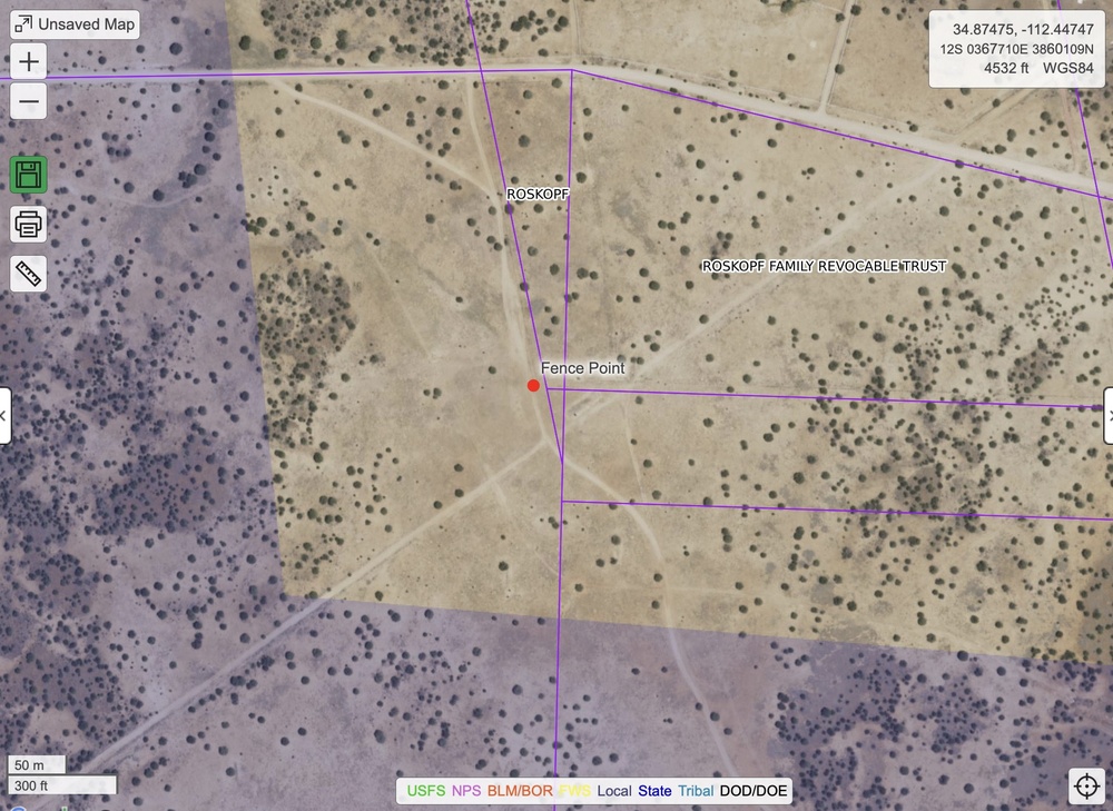 |
|
|
I don't have any experience whatsoever with the particular area, but am curious. Does AZ have any public right of way law? If so, would it potentially impact this road? |
|
|
Good luck dealing with this issue. I live on “checkerboard“ (State/Private) land NE of Flagstaff. The rancher who leases the State lands has put locks on the gates of about 50 sections (or around 30000+ acres of land - he “owns” almost half and half is owned by the State). On a ride with the Game Warden he explained that ranchers often build fences just inside their property line and that it’s completely legal. There‘s only minimal climbing out there that I’ve seen, maybe a few boulder moves here and there, but it used to be a nice place to get outside. Someone above provided a useful link to the ASLD website. Key takeaways I’ve dealt with from the code (heavily redacted): In addition to the prohibition against posting proscribed under A.R.S. § 17-304, a person shall not lock a gate, construct a fence, place an obstacle, or otherwise commit an act that denies legally available access to or use of any existing road upon state lands… The provisions of this Section do not allow any person to trespass upon private land to gain access to any state land. Keep us posted. |
|
|
We were shut out a few years back as well. There is a road, sorry it's been too long to remember the name, just a couple miles north of the DEPOT. On a long round about way, you can circle the neighborhood and get to the original parking lot. With that new beta, please let's not trash the road by going out in the mud! You can look at MAPS to find the road through the trailer park to the crag. Steve |
|
|
Hey Everyone, After further investigation, the fence is easily circumnavigated. There is even a new "road" to go around it already. However, this is a good warning that we cannot rest on our laurels and we need to be more proactive about securing sustainable access to this climbing area. |
|
|
MacM wrote: Just to confirm, is the approach basically the same except this small bypass or do I need to take completely different roads? |
|
|
Basically the same now that the bypass is bedded in, you might not even notice |


