Mountain Project Logo

USFS emergency closure of the Spring Mountains (UPDATED 10/27, smaller closure area)

Original Post
Desert Rock Sports · · Las Vegas, NV · Joined Aug 2019 · Points: 2

The closure is still pretty extensive, but progress is being made:
https://www.gomtcharleston.com/spring-mountains-weekly-update/

Area closure remains in effect for the Developed Recreation Canyons (Lee, Kyle, and Deer Creek) of the Spring Mountains National Recreation Area (Mt. Charleston) accessed via Highway 156 (Lee Canyon) and Highway 157 (Kyle Canyon), and Highway 158 (Deer Creek) for public safety due to historic storm damage. State Route 156 to Lee Canyon is now open. The other two main highways to the Mount Charleston area, State Route 157 (Kyle Canyon Road) and State Route 158 (Deer Creek Road), are scheduled to open, weather permitting and without any unforeseen factors, over the next two weeks – State Route 157 on Friday, Nov. 3, and State Route 158 on Nov. 10. Drivers are asked to use caution as there are still many repair workers and vehciles in the area actively continuing additional repairs.

The Spring Mountain Visitor Gateway, Lee Canyon Ski Resort, and all trails, picnic areas, and campgrounds remain closed but will be reopend gradually as able over the next few weeks. Additional details and a closure map are available on the Humboldt-Toiyabe National Forest website. This Forest Order does not apply to private parcels, state highways, or any other non-Forest Service property within the boundaries of the Spring Mountains National Recreation Area. Emergency Closure and Map of Area 

Lovell Canyon and Cold Creek roads have some impassable washouts, please avoid the areas.

TRAILHEADS OPEN UNLESS NOTED (*) BELOW:
*None

CLOSED TRAILS:

  • Bristlecone, Lower
  • Bristlecone, Upper (access to south end of Bonanza Trail)
  • Cliffrose/Stepladder
  • Deer Creek
  • Desert View Overlook
  • Mary Jane Falls
  • Echo
  • Cathedral Rock/South Loop/Griffith Peak
  • Fletcher Canyon/Eagle's Nest/Acastus
  • Harris Spring to Griffith Peak
  • Juniper
  • Mahogany CCC (trailhead will close with winter conditions)
  • North Loop/Rain Tree
  • Pack Rat/Escarpment/Acastus (from Spring Mountains Visitor Gateway, trail has some erosion hazards)
  • Robber's Roost
  • Trail Canyon

PICNIC AREAS:
OPEN SITES*:
*None


CLOSED SITES:

Kyle Canyon (Day use and camping)
Cathedral Rock Picnic Area
Deer Creek (Free, first come first serve, open dawn to dusk)
Sawmill (free, first come first serve, open dawn to dusk)
SMVG Group Picnic Areas (reservation required)
Lee Meadows (open dawn to dusk, groups must be under 20 people, NO camping or fires)
Old Mill
Foxtail Group Picnic Area

*All Federal Public Lands Pass (Access Pass, Military Pass, Senior Pass, Annual Parks Pass, and Every Kid in a Park Pass) holders are permitted free usage at single picnic sites at all day use picnic areas except for SMVG, Foxtail, and Cathedral Group Picnic Areas. Pass must be present and its information must be filled out on a fee envelope and deposited in the fee tube at the Self-Service pay station. 

CAMPGROUNDS:
OPEN SITES*:
*None

CLOSED SITES:

Fletcher View
McWilliams
Hilltop Campground
Mahogany Grove Group Campground
Mack’s Canyon (undeveloped & unpaved)
Blue Tree Area (undeveloped & unpaved)
Champion Road (undeveloped & unpaved)

*Dispersed camping is prohibited currently in Mahagony Fire burn area

LEE CANYON SKI RESORT

The Lee Canyon Ski Resort is closed until further notice- visit their website for details

Word on the street is that Fletcher and another canyon trail and trail head may open up very soon, but basically everything is still closed. Fines still apply.

tdoughtyjr · · Paonia, CO · Joined May 2010 · Points: 5

Bummer. I've seen similar events result in some access points never reopening at current locations...

Adam W · · TX/Nevada · Joined Dec 2019 · Points: 532

Per Facebook posts comedy crag area is accessible but the road is closed before story crag.

Charlie S · · NV · Joined Aug 2007 · Points: 2,415

I think it's preposterous that the USFS has closed off the entire boundary, when the intent of the closure is clearly to keep people off of Mt. Charleston.  It's an overstepping of bounds, but I'm not sure how to get them to correct their error.

Adam W · · TX/Nevada · Joined Dec 2019 · Points: 532
Charlie S wrote:

I think it's preposterous that the USFS has closed off the entire boundary, when the intent of the closure is clearly to keep people off of Mt. Charleston.  It's an overstepping of bounds, but I'm not sure how to get them to correct their error.

Agreed, the road to sleepy hollow has been shit for years it’s not a paved road like the ones into Charleston and it didn’t just get damaged now in recent rains

Austin R · · Las Vegas, NV · Joined Aug 2018 · Points: 2

Go anyways

Adam W · · TX/Nevada · Joined Dec 2019 · Points: 532

They released an updated closure that if I understand the map seems to have potosi and Lovell open on august 30 facebook.com/10006442304329…

Southern Nevada Climbers Coalition · · Las Vegas, NV · Joined Sep 2017 · Points: 9
Adam W wrote:

They released an updated closure that if I understand the map seems to have potosi and Lovell open on august 30 facebook.com/10006442304329…

Correct, forest service has communicated the order takes effect today and goes until further notice. Kyle, Lee, and Deer Creek remain closed. But, the surrounding parts of the Spring Mountains National Recreation Area are now open to the public.

Southern Nevada Climbers Coalition · · Las Vegas, NV · Joined Sep 2017 · Points: 9

Map of closed areas (click link for somewhat better resolution):
https://www.fs.usda.gov/Internet/FSE_DOCUMENTS/fseprd1135510.pdf

Charlie S · · NV · Joined Aug 2007 · Points: 2,415

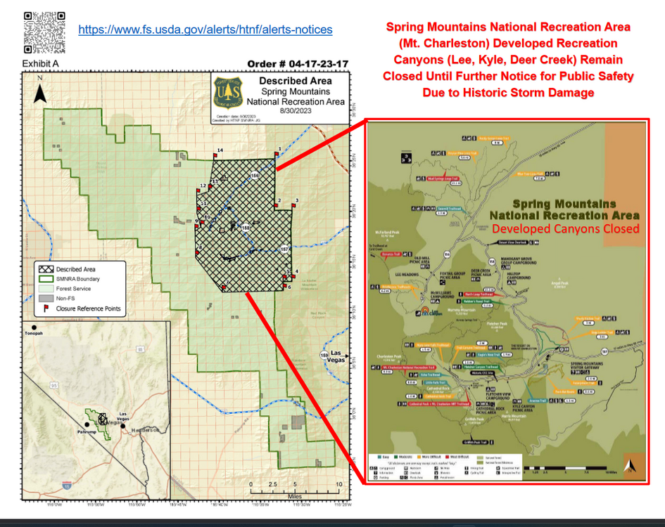
Yeah also saw that.  Not sure if that's just a knee-jerk time frame to keep people out or what.  I can't imagine all the trails being closed for 2 years.  Maybe some new warnings like "trails not maintained" and let people figure it out.

Unfortunately, it's so early in the process and there's so much damage to fix (like the access roads) that making a stink out of 2 years is not going to get us access faster.

It'll become apparent, though, that once the ski resort opens and the roads are fixed what the USFS's plans are.  My guess is that a lot of the trailheads and parking areas need massive repairs before access can be restored.  Past that, I would hope that some simple warnings of trail conditions would be sufficient.  The standard city-slicker looking for a lazy walk may have a hard time, but climbers are not strangers to less-than-ideal trails.

Desert Rock Sports · · Las Vegas, NV · Joined Aug 2019 · Points: 2

I would not be surprised if this was also prompting taking significant time to plan and implement better runoff management there. Which could take a lot of time if it has to be implemented not just near the roads but well uphill in advance of them.

Joe Wysznski · · Unknown Hometown · Joined Jun 2012 · Points: 207

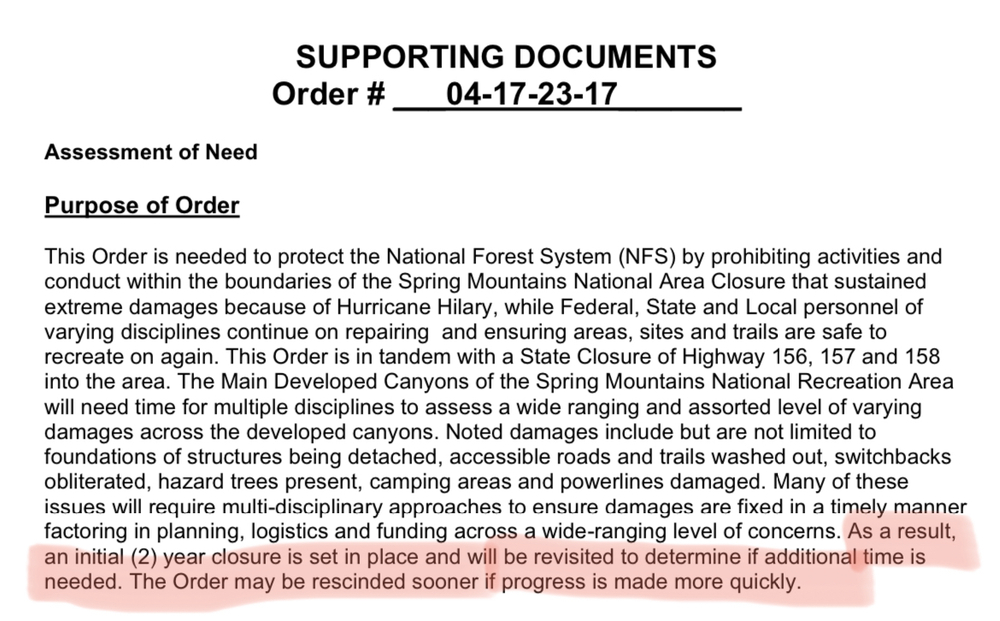
The 2 year closure is just a generic timeline possibility. I dont think it will necessarily be that long although it could. I posted a link below for volunteering opportunities for trail work. Likely will be a bit before that takes place but many trails will need a lot of help. 

Want to help? Sign up to be notified here: Flood Cleanup

https://secure.lglforms.com/form_engine/s/iL0eE30vMqKSbUEsCcsgKA

Travis O'Neil · · Las Vegas, NV · Joined Feb 2013 · Points: 526

Update on closures, etc as of 10/03/2023 (yes, Kyle and Lee are still closed)
https://www.dot.nv.gov/Home/Components/News/News/7954/395

Desert Rock Sports · · Las Vegas, NV · Joined Aug 2019 · Points: 2

Bump, updated first post. Most everything is still closed. Fines still apply.

Desert Rock Sports · · Las Vegas, NV · Joined Aug 2019 · Points: 2

More areas are opening up.

Desert Rock Sports · · Las Vegas, NV · Joined Aug 2019 · Points: 2
Guideline #1: Don't be a jerk.

Nevada
Post a Reply to "USFS emergency closure of the Spring Mountains…"

Log In to Reply
Welcome

Join the Community! It's FREE

Already have an account? Login to close this notice.