
 Continue with onX Maps
 Sign in with Facebook


CalTopo current snow depth satellite imagery
|
|
I used to be able to get snotel data imagery on current snowpack via satellite (I believe it was weekly updates) but I can’t find that option anymore. Anyone mind helping a non tech savvy figure it out. I have the pro version. |
|
|
Are you looking for snow depth and SWE estimates (i.e. SNOTELs), or satellite imagery for snow coverage? Here are the free online options: For direct observation of snow coverage, this is my preferred site for super-recent satellite imagery. Can usually get a clear image within the past few days (as long as it hasn't been too cloudy). This is what I usually use for the "is the crag snowy" question. The user interface is a bit awkward, but you can figure it out. Basically, you want the data from Sentinal-2, hit search, choose a date without too much cloud cover, click on "true color", then give it a minute to load. If you want a map of modelled snow depth and/or SWE, your best option is NOHRSC. This is a modelled product, but incorporates observed data to tune it. Lots of other data in there too like melt rate, if you want to get deeper into the snow modeller. Again, the user interface isn't the best. https://www.nohrsc.noaa.gov/interactive/html/map.html For SNOTEL data, look here: SNOTEL mapper |
|
|
Much appreciated! I’ll check it out when I get back. CalTopo users: any in app features I’m missing or did they lose their license or something |
|
|
I see it under layers in Caltopo (Sentinel Weekly). Might be a Pro/paid feature. |
|
|
Sentinel weekly is a paid caltopo feature. You can get the same imagery through the sentinel hub link posted above by JCM, but it's a lot clunkier. The weekly (it's actually more like every 3 days) imagery is pretty much what sold me on paying for caltopo premium. Super easy to line up with trails or markers and flip back and forth between topo overlay. My pro tip is to use the "false color green" setting to differentiate between snow and clouds and really make the snow pop out. This doesn't help with snow depth, but does help for early/late season "is this skiable/hikeable" |
|
|
As other have said--Sentinel weekly images are still available for free out there, but no longer on caltopo. However, it's really, really nice to use the paid caltopo features because of how easy it is to layer in helpful info. I agree the false color green helps, and it is even better with some relief shading. Add in the snotel weather stations and it's all in one place: 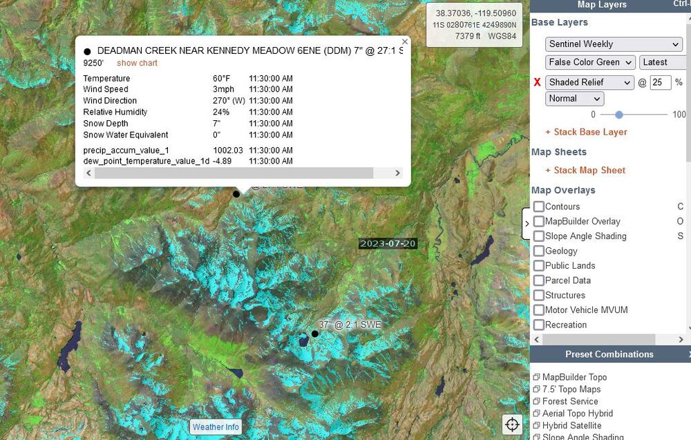 |
|
|
Spopepro O. wrote: Perfect. I’m a idiot and thought it was under Mapsheets or Overlays. How did you get that pop up with the weather and snowpack data? |
|
|
M L wrote: How did you get that pop up with the weather and snowpack data? Check the box for “weather stations” and then select “snowpack”. Click on the black dots for details. |
|
|
M L wrote: You need to have a pro level, which I think is $50 a year, subscription to access the current satellite imagery. 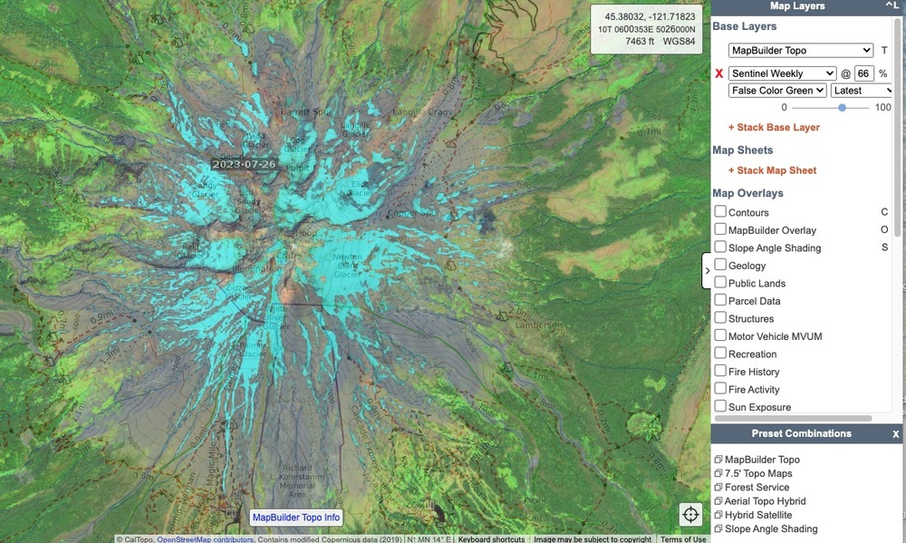 |
|
|
Thanks I think I figured it out . I have the paid subscription but I’m not very bright |
|
|
M L wrote: Hey no worries glad you found it. I still get confused by those drop-down menus on the right hand side and I've been doing this for a while. |


