
 Continue with onX Maps
 Sign in with Facebook


ClimbingWeather.com vs. Mountain Project - Which is more accurate?

|
Hey all - I'm looking for somewhere to climb near LA Friday. ClimbingWeather.com says it'll be 98° at Frustration Creek, but Mountain Project's page for Frustration Creek shows 84°...WHICH ONE IS ACCURATE? Any insight appreciated! |
|
|
I'm not sure where the weather station climbingweather.com uses is, but I would be inclined to trust their forecast more. If you click on the MP weather forecast, it takes you to the National Weather Service info they are referencing. You can see the point forecast is for 7,005 ft and I believe the crag is at around 4,800 ft. 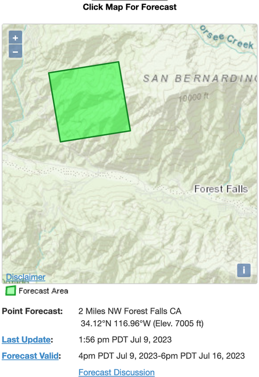 |
|
|
Climbingweather aggregates from the national weather service based on exact lat/long. |
|
|
Aaron Liebling wrote: As does the MP forecast. So in this case both are using the NWS point forecast (this is a good thing). The forecast difference is likely attributable to the location being slightly different. This can be a big difference in rugged mountain terrain, where shifting over by one NWS grid cell can mean several thousand feet of elevation and a notable temperature difference. The best solution is to become a more informed user of forecast products. Know the location and elevation of your crag, find the correct NWS point forecast location, look at the hourly data graphs to understand the temperature changes through the day, know the sun/shade hours for your crag, etc... Mountain weather is complicated, and if you just follow basic app information you're going to get inadequate information a lot of the time, which will hinder your climbing trip planning. There's a lot of days when the high temperature for the day, or a little rain drop icon in the weather app, suggest it's not a good day to climb. But a bit more investigation into exact point forecast, the hourly temperatures, the timing of the precip, etc may suggest there's actually a window to get in a good climbing session - if you plan correctly. |
|
|
Thanks all! |

|
i have found the MP weather forecast to be a lot less accurate than climbingweather.com. Honestly, i don't even look at the MP weather. i see you are in JTree. probably my favorite site for there is windy.com, as it provides good wind info (hourly plot of speed and direction). |
|
|
JCM wrote: Usually I first find the elevation of the crag (e.g., topo map). If the NWS grid cell with the crag is off, I check if neighboring NWS grid cells have a better elevation match. If one does, I’ll use that for my forecast. But maybe elevation is not so primary in forecast models? |
|
|
Go directly to the forecast by the folks that produce the data source: https://forecast.weather.gov/MapClick.php?lon=-116.95263862609863&lat=34.09991250469062 |


