
 Continue with onX Maps
 Sign in with Facebook


Accessing the Maze-Canyonlands


|
|
I’m curious about the two approaches to The Maze, either heading east from near Goblin Valley or north from Hite Marina, and what the generally preferred route is. Ideally I would like to drive my 4WD Tundra long-bed into The Wall or Chimney Rock campsites this April/May without leaving a trail of parts. Hoping to hike an overnight loop including the South Fork of Horse Canyon to Maze Overlook and back one of the parallel trails. This would be after hiking Fish & Owl Creek Canyon loop in Bears Ears, so driving in from there. Also, do any shuttle services operate in Bears Ears? Also considering Grand Gulch to Collins Spring Trailhead, but it’s some 25 miles back to the start via road. |


|
Call Canyonlands NP and ask them for current conditions. |
|
|
You will probably need a permit to drive in there and maybe one for a campground. |
|
|
Generally speaking the route from Goblin Valley to Hans Flat and down is more regularly maintained throughout the year. Doesn't mean it can't be terrible, just generally fixed faster than the Hite route. NPS requires certain vehicle specs and equipment requirements for that part of CANY so call ahead and/or jump on the website to make sure your vehicle meets the requirements, and you can demonstrate the proper recovery equip. when you check in. You will need a backcountry camping pass as well so get that as soon as you can to get the locations you want. Don't know of any shuttle services out of the Bears Ears area but I would check with the tour companies in Blanding, likely your best bet if one exists. |
|
|
Years ago I hiked in the Maze using a motor boat shuttle from a local canoe outfit. Not cheap, but cheaper than a “trail of parts” and faster too. Left us off at Spanish bottom I believe |
|
|
JaredG wrote: That would be Tex's riverways if you want to go that route. Drops you off at Spanish Bottom, where you can hike up to the Dollhouse and beyond. |
|
|
Thanks for that info, Karen! |
|
|
I haven't done the Hite route but I hear from others the Hans Flat way is preferred route. I'd call it 5.9+ even in good conditions. Flint trail is steep with tight switchbacks and drops, will take maneuvering with a long bed for sure and you likely won't get to choose the easiest line due to your wheelbase length. Expect to be backing up to reposition on steep loose terrain and probably positioning rocks to keep your frame off the ground. I wouldn't do it solo in a long bed unless you're experienced in that type of terrain, it would be really nice to have a spotter. It also descends a clay layer, so wet can be very bad. Generally, after the flint is ok, but still chances of washouts, random rocks and obstacles. Bring enough fuel and supplies to go out another way, sometimes there are random rock slides that can block sections or if there is a micro burst the mud is too gnarly to get back up the flint. |
|
|
I did this as a passenger 5 or so years ago, so conditions might have changed. I'm not an offroader at all. Our driver was a guy from Tennessee who's primary outdoor activity was 4WD. But I remember a spot just past "Teapot" labeled "vehicle damage will occur past this point". Sure enough, we reached a point just past (1/4 mile?) teapot where we scraped up the truck. The obstacle that stands out in my mind was a vertical stair down, followed by 10ft or so of flat, followed by a vertical stair up. The pickup truck we were in was simply too long to sit in the flat part, and when we tried to climb out the receiver would hit the stair behind us. A shorter vehicle (Jeep) would have handled it no problem. I'll also add that we basically spent 4-6 hours driving from Teapot to Dollhouse. Everything was drive-able besides that one spot, but it was very slow going for someone who prefers hiking/biking/climbing to sitting in a car. We came in Hans Flat, and went out Hite Marina. I remember the road out was long and flat. The road in, down the flint trail, was steep, and we had people get out of the car to do 3 point turns around the switchbacks. If I ever go back, I'll camp at Teapot, and bring a mountain bike to get further in. |
|
|
Edge wrote: From: https://www.nps.gov/cany/planyourvisit/road-conditions.htm
Others mentioned the key points - there will be two major difficulties for you: the Flint Trail and getting around Teapot Rock. Flint Trail: steep, many tight switchbacks, pickup trucks will need to do several multi-point turns. How rough it is will vary depending on when it was last graded and rain/snow since then. You'll be using engine braking in 4-Lo the whole way down. Do not underestimate that clay bench mentioned above. When it's wet it's about as slippery as ice and there is huge risk of sliding off the road. Teapot Rock: the one mile or so getting around Teapot is the single most difficult 4x4 trail in the Maze. With a pickup expect multipoint turns, rock stacking, and scraping the underside. Know where the tender spots are under you vehicle, use a spotter, and make sure of careful wheel placement. Expect that one mile to take over an hour. General considerations: Basically, be self sufficient -
Flint Trail vs the road from Hite: the former is discussed above and in other posts; the latter is much longer (fuel issues) but much easier technically (unless there have been serious washouts). The last time we were in there we entered via Hans Flat/Flint and exited via Hite. The hike up to the Dollhouse from Spanish Bottom on the river: it's a grueling 2K' of elevation gain and remember there is basically no water in the Maze. Add in camping (and climbing?) gear and there is no way in hell I'd ever consider that. |
|
|
Synopsis: YGD |
|
|
Marc801 C wrote: Lol I don't remember it being a big deal, but I was younger in those days. Looks closer to 1K' than 2K'. We did find water (in Autumn) somewhere down in the canyons, but I wouldn't count on it. (Although if there's snow all over the roads I'd guess there's water to be found.) I recall we even packed a flask of wine. |
|
|
JaredG wrote: Yeah, probably around 1200' - 1400'. Still a slog though. 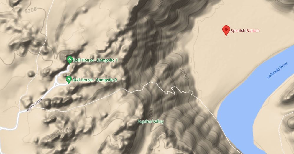
Yep. It's hit or miss. I wouldn't want to have to depend on finding water. According to the NPS, there are no potable water sources in the Maze. |
|
|
Edge wrote: Here's a 4 min video of the terrain at Teapot with a full length pickup: |
|
|
Marc801 C wrote: That guy is really good at getting through some shit in a too-big truck. |
|
|
I'm curious to know if it's possible to drive a Subaru Outback as far as Teapot Rock via the road from Hite, and park there as a trailhead? It seems that is where it becomes impassible for high-clearance AWD, and perhaps it's possible to park somewhere in that vicinity? Sure would make an easier access to the Maze than Flint TH...especially to avoid the the 1600'+ elevation gain for the hike out via Golden Stairs. |
|
|
Scott Melcer wrote: I've encountered stock Outbacks at the Maze Overlook campsite, so I'd say yes to going to Teapot Rock (but no further). There's a campsite there; IIRC there's space for parking. The road in from Hite shouldn't pose any problems. |
|
|
Scott Melcer wrote: Awd vehicles are no longer allowed for those roads due to the amount of extractions that had to happen. Contact the ranger station for more info. |
|
|
Bolting Karen wrote: Not quite. AWD is not allowed on trails specifically designated as 4WD trails - eg: Flint Trail. The trail from Hite to Waterhole Flat is designated as high clearance 2WD/AWD as is the portion to get to Teapot Rock. |
|
|
Marc801 C wrote: Thanks Marc! I'm surprised by Outbacks at Maze Overlook, and would love to make it to that TH! |
|
|
Scott Melcer wrote: I suspect they scraped bottom more than a few times and had to stack some rocks. |


