
 Continue with onX Maps
 Sign in with Facebook


Stage 3 (Full Closures) to New Mexico National Forests - status of what is open & closed


|
|
Carson, Santa Fe, and most of Cibola National Forests closed May 19 (Lincoln NF closed May 25) because of fire risk. THESE ARE ALL LARGELY REOPENED AS OF NOV 30, except for some areas close to 2022 forest fire burn areas. I'll keep a list posted here of what's open/closed for the more established climbing areas in New Mexico. ~~Updated 10/31~~ OPEN: -Cibola National Forest & Grasslands: Sandias, Palomas and nearby areas, Big Block, New Canyon, Enchanted Tower, Monster Island, Roy. Cibola NF announcement -Santa Fe National Forest: Las Conchas, Upper East Fork, Area 37, Diablo Canyon (SW side), Dungeon, Capulin, Cochiti, Ponderosa, Pecos, Gilman Tunnels SFNF announcement -Carson National Forest: El Rito Sport Area, Little River Wall, Tres Piedras, Questa Dome, areas near Red River, Ortegas, Comales, El Rito Trad Cliff. Carson NF announcement -Lincoln National Forest: Tunnel, Last Chance, Sitting Bull, areas near Ruidoso. Lincoln reopening announcement. -BLM: Socorro Box, Diablo Canyon (NE side), Taos Gorge, areas near Las Cruces and TorC (Organs, Rough & Ready, Luna Park, Bat Cave, etc.). -State Parks: Sugarite, City of Rocks -Albuquerque Foothills Open Space: some Sandia foothills areas like U-Mound, Carnuel. -Los Alamos County Open Space & National Laboratory: White Rock, The Y. Los Alamos County Open Space announcement. LA National Lab lifted fire closures on 6/23-- was posted on its internal page. -city of Gallup/private: Mentmore CLOSED: nothing!!! (we made it!) ----- This is just to be helpful- I'm not an authority (or your mom). Realistically, the rangers will probably not post "closed" signs or tape off with flagging at every single minor approach trail, but that doesn't necessarily mean any areas they missed are legit. I'd bet most forest roads that have gates will be locked. I will try to keep this updated based on what I hear, read, or your comments. As things change (or if there are inaccuracies), please let me know. I'll try to be responsive, but may get out of the state some. Love it or leave it. |


|
Thanks for putting this together, George. Super helpful! Hopefully we get some moisture soon. |
|
|
Thanks George! |
|
|
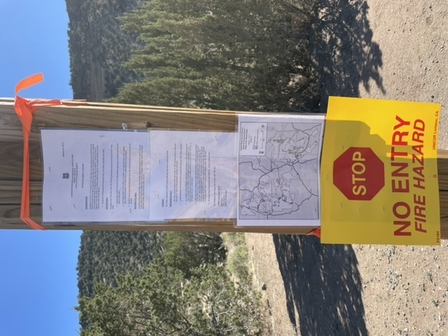
The Lincoln National Forest will implement a stage III (closure) beginning Wednesday, May 25th, 2022 at 8:00am. The order is valid through July 30th, 2022. This affects the Tunnel, Last Chance, Sitting Bull and the Ruidoso Area areas, among others. https://www.fs.usda.gov/detail/lincoln/news-events/?cid=FSEPRD1026537 |
|
|
 When in the parking lot take the dirt road to the right toward the cliff then continue up the talus field to access Winter Wall and the Solar Cave while still following the rules (I think, this is what we and one other group determined but can’t say for sure). |
|
|
Thanks for the info, Nicole. If one views the land management boundaries on CalTopo, it shows the national forest land on the south side as starting more or less on the south side of the arroyo and a bit in the middle of the arroyo closer to the parking. I think the sign posts along the fence line are just convenient places to post the signs/notices and not indicative of the boundary: 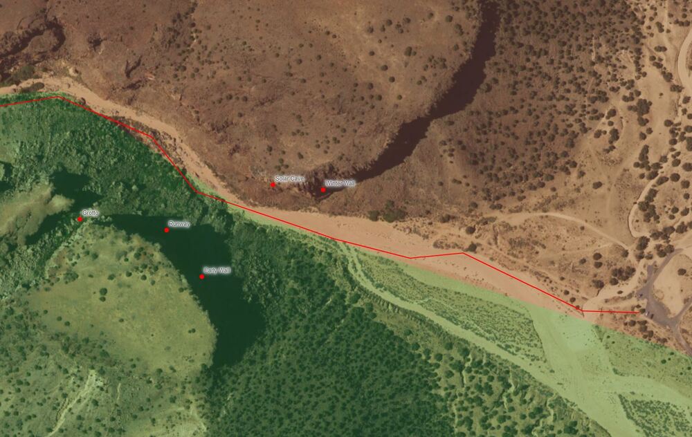 Opinion: These blanket closures are pretty silly and lazy. I understand the intent of the closures but closing off access to the low-laying, low fire risk areas like the Grotto area while access is still kosher on the other side of the arroyo doesn't make sense. |
|
|
I'll confirm Nicole and Jason's posts about Diablo Canyon. You should be able to legally climb Winter Wall - Solar Cave. Sky and I chatted with 2 rangers last Monday (1 Forest Service, 1 BLM) in the parking lot and they said "have fun" when I said we'd be climbing on those cliffs all summer. They said the BLM-SFNF boundary was the fence— which does have tape across its gate to the wash when I went on 5/26. (I didn't argue with them about what the county assessor maps show, or point out that the fence just "ends" below the Winter Wall straight down the talus from Post Moderate, and that it doesn't run continuously through the canyon.) During the last closure (2018), I climbed Solar Cave every week throughout the summer and had no issues, besides heat and rattlesnakes. In 2018, a friend of mine did get fined for going in the Grotto after others had said they had climbed there and not had any trouble. I have been asked about the Eden and Cockscomb areas. For those, although you park on BLM land, those cliffs are on the closed (SFNF) side of the boundary; I have no idea if they flagged off the approach trails. EDIT 6/24: DIABLO FULLY RE-OPENED as Santa Fe National Forest re-opened. ---- UPDATED 5/27: White Rock (most of it- the County-owned portions) has re-opened. cdn5-hosted.civiclive.com/U… Surely in part due to the efforts of various climbers and hikers who wrote and contacted Los Alamos County. ---- Thanks to those of you who've provided feedback, updates, or suggestions (here or off-line). |
|
|
Jason Halladay wrote: I tend to agree, we will prob be entering stage III for many of our forests soon too, and we will be dealing with arbitrary lines that do not make sense as well, which I have just tended to accept as an acceptable means to protect our forests. However, the stage III closures in NM seem a bit knee jerk to me and a little off, even for the poor winter and drought. The current closures seem to be more about the FS over-compensating and trying to make right what will perhaps go down as a couple of the worst blunders in forest management history here in the SW. No matter how you cut it, at the end of the day, the worst forest fire in New Mexico's state history will be one that was started by the FS. Its reassuring that they owned it, however, its extremely disheartening to know that with all of the things threatening our forest here in the SW, now we have the feds starting the fires through negligence and incompetence. They conducted a prescribed burn on a red flag day and failed to put out another one they hard started weeks before. Had someone displayed some competence on either of those two projects, NM would probably be in stage II and the public would not be locked out of their forest. "TAOS, N.M. (Reuters) - Two blazes that grew into New Mexico's largest ever wildfire were both started by the U.S. Forest Service (USFS), the agency said on Friday, 5/27. Forest Service investigators determined the Calf Canyon Fire was caused by a "burn pile" of branches that the agency had ignited and thought was out.... but it reignited on April 19. That blaze on April 22 merged with the Hermits Peak Fire, which the USFS started with a "controlled burn" in windy conditions that went out of control on April 6." |
|
|
Should I reconsider my planned trip to Taos in July? It seems like any summer-friendly climbing (and hiking and biking?) will be off limits? What might be available? Thoughts? Thanks, Matt |
|
|
It's Matt wrote: Until the monsoon arrives in July, it’s hard to know if there’ll be enough moisture for the forests to reopen. I’m not sure if the bike park at Taos is affected by the closures |
|
|
It's Matt wrote: The Taos Gorge basalt areas like Utopian Vistas, Dead Cholla and Vista Verde, for example, are open for climbing. They're not ideal in summer but do get afternoon shade. Hiking and biking will be severely limited. The Angelfire ski area biking trails are open. Typically NM gets monsoon rains starting in early July but that's not guaranteed, of course, and I don't know how quickly the forest service will open lands once the rains start. |
|
|
The Mentmore climbing area is owned by the city of Gallup. This area is restricted to the cliffs on the east side of the train tracks (if you look on Google maps). The west side of the tracks with more cliffs is private land. |
|
|
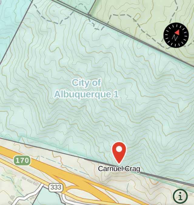
Looking at where Carnuel Crag is relative to the FS boundary, I think it's open, but I'm not 100% confident about that. Does anyone have insight on that? |
|
|
 |
|
|
Thank you Anna! Much appreciated. |
|
|
Santa Fe National Forest partially reopens Friday June 24. https://nmfireinfo.com/2022/06/23/santa-fe-nf-lifts-forest-wide-fire-restrictions-june-24/ --Some areas near the fires remain closed. --Crags reopening: Diablo, Dungeon --crags reopened July 1: Las Conchas, Upper East Fork, Area 37 [7/1 EDIT as new forest order released] --crags reopened Aug 2: Capulin, Cochiti, Ponderosa [8/3 EDIT as closure was updated] --reopened Sept 2: Pecos River Canyon [9/2 EDIT] --reopened again Oct 16 after rockfall closure: Gilman Tunnels [10/17 EDIT] --------------------------------------------- Cibola National Forest also reopens Friday June 24. (All areas listed in original post should be open.) -------------------------------------------- Carson National Forest will mostly reopen Friday June 24. Some areas near the fires remain closed. https://www.fs.usda.gov/detail/carson/news-events/?cid=FSEPRD1037730#:~:text=Carson%20National%20Forest%20managers%20will,with%20each%20unit%20for%20details --Reopening: Questa, Ortegas, Red River areas, Tres Piedras, Little River Wall. --Reopened 8/31: El Rito Sport Area --Reopened 9/14: Comales Canyon --Reopened 10/30- El Rito Trad Cliff [EDITS TO THIS SECTION RE: EL RITO 6/29 and 8/31 and 10/31] [EDITED with updated Camino Real closure 8/26 and 9/14] ---------------------------------------------- Los Alamos National Lab lifted fire restrictions on its open space on 6/23. This fully re-opens the White Rock area. [this was posted on lanl homepage] --------------------------------------------- Lincoln National Forest reopened 6/24 (all areas in original list should be open). fs.usda.gov/detail/lincoln/… |
|
|
Is Apache Canyon open? |
|
|
Apache canyon is SF county open space. |
|
|
Is El Rito opened back up yet? |
|
|
I heard from a Carson NF recreation staff member today that FR44, the road to the El Rito sport and trad areas got flooded out with the recent rains. Major debris flows (large limbs, boulders, mud, etc.) on the road, directly related to the Midnight Fire burn scar, have made the road impassable. Thus, the forest service is closing FR44, all climbing areas, and dispersed camping near the climbing areas along FR 44 through August 31 to coincide with monsoon season ending (an estimate date, of course). It's unclear how long it will take to repair the road after monsoon season. I'll post a link to the closure order once it is online. |
|
|
Santa Fe National Forest has reduced the extent of the Cerro Pelado closure as of Aug 2. https://fs.usda.gov/Internet/FSE_DOCUMENTS/fseprd1046766.pdf This reopens all remaining climbing areas in the Jemez that had been previously closed: Ponderosa, Capulin, Cochiti. (Las Conchas, Upper East Fork and Area 37 were reopened earlier.). [edit: this closure was lifted in its entirety on 9/1] |


