
 Continue with onX Maps
 Sign in with Facebook


Snow Creek Trail, San Jacinto

|
The infamous bushy traverse from Falls Creek saddle to the Side Canyon is a mellow hike at present due to the brush fire from a couple of years ago. The open hillside was taken advantage of and a high traverse that has moderate gain and a decent foot bed is now an option- keep an eye out for Poodle Dog Bush shrubs in the burn areas. General trail and cairn work was done from the saddle above Falls Creek (4,300) to the traverse before the Side Canyon drop-in (4,680). To clarify; the established trail stays low above Snow Creek, then ascends to the Side Canyon portal- The new option is a gradual side hill gain, a few short switchbacks, then a level traverse. The ridge before the drop-in to Snow Creek also had a fair amount of work done and is straight forward. The conditions seemed decent for an ascent as of February 21st- dependent on the snow accumulation from current front passing through. 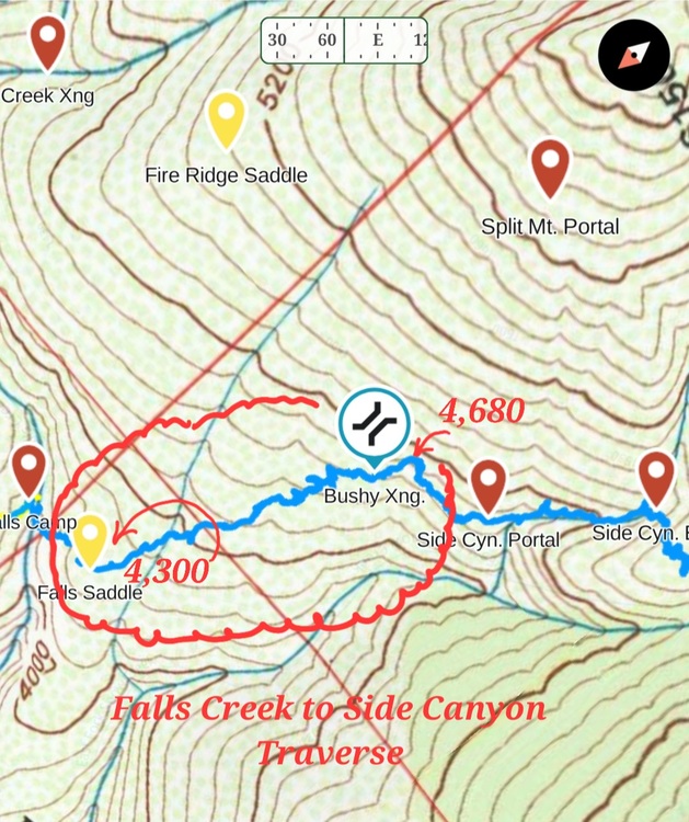 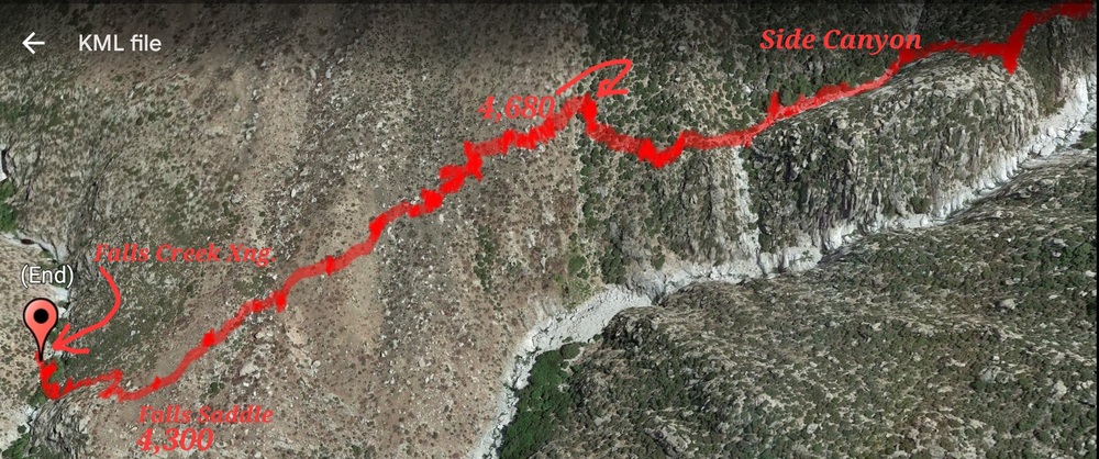 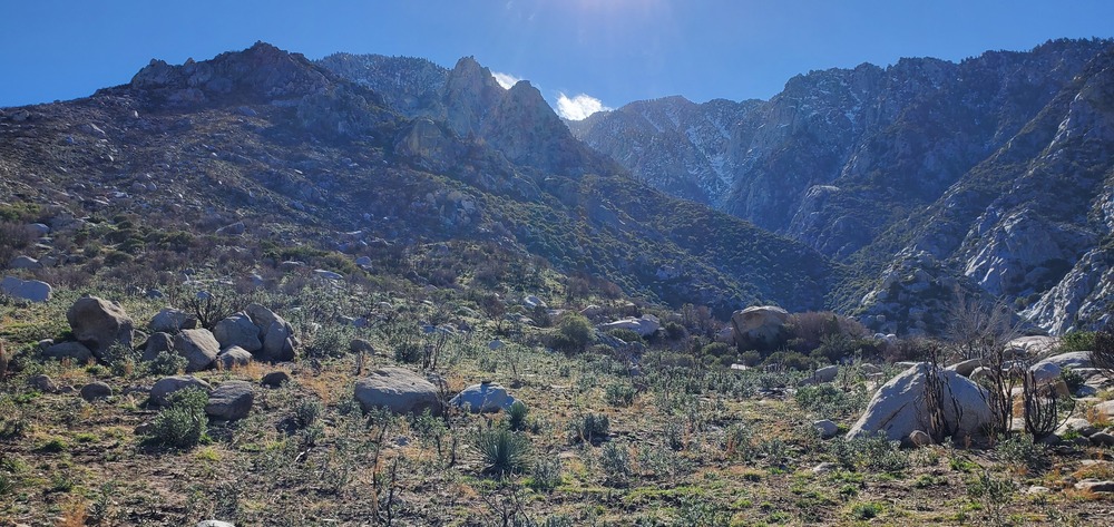 The view from the saddle above Falls Creek |
|
|
Could you post another todo photo a bit more zoomed out? I attempted to go up Snow Creek many years ago, but ended up dropping into the snow creek canyon too early and got cliffed out after a series of waterfalls, and I’d like to see where this path cuts in. Also, does this route avoid the water facility at the base of the mountain? |
|
|
Emilio Sosa wrote: I'll drop a Track and a clearer image of the 4,300 to 4,680 line on this post. It's very repeatable at this point. My trail partners and I have established an all pubic land access route with great parking from a canyon to the East. It's not as efficient as the illegal trail but I can't jeopardize my sentry pass for Mexico surf trips. It's about 7 hours to the Choc Stone. This beta, I would DM you if your serious about giving it a go. We have 3 or 4 trips up there with great camping and trail work done. It's a pretty surreal trek, we dropped down from absolute remoteness, soring landscape and giant mountain lion poops to a tweaker on a mountain bike on the desert floor. |
|
|
I’ve never attempted this route but have always thought about it. Would be great to get more detailed beta if you have it. Especially for the entrance trail that avoids the water district. |

|
I'd love the track too please |
|
|
https://www.gaiagps.com/public/i8e21jCrRnQZ3twkr8xiH0xj https://www.gaiagps.com/public/2vrrudg10qOIAEJoYwUmEBsw The Snow Creek East Trail links up to the other "legal" trail at the top of the big bench near hill 4,340'. Prior to the link up at the big bench, the trail is a connection of an established walking path in Blaisdell Canyon to all, off-trail travel with ridge and slope traverses on game trails- no bushwhacking involved. This is raw territory with hazards. This trail exists only to take advantage of favorable parking and unfettered return trips to the trailhead. There is no claim of easy travel or time savings- use at your own risk. Advice is to start at dawn and recon the trail to Falls Creek and back to the trailhead prior to an ascent of the summit. |
|
|
Summited via Snow Creek, East Trail last week. Final stats: Trial head to Chockstone- 7 hours Chockstone to summit- 8 hours (for out fittest member). Start elevation- 900' Total gain- 9,934' The new trail gives access, in and out, to quite a bit of rock, ice and backcountry camping. I think the opportunity for a harder and more technical version of Lone Pine, NE Ridge exists on the formations above Falls Creek. The recent fire and access options have reduced the effort getting to these lines although it's still quite a push getting back there.  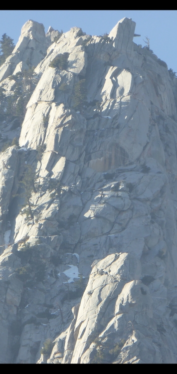    |
|
|
Final Summit track with a few glitches due to satellite reception issues. |
|
|
Anyone wanna hike out here Tuesday or Wednesday ? |
|
|
I'm still revovering from a big run on wednesday, but i should be available for an attempt on Tuesday. I'd have to do C2C since i have an appointment on Wednesday. Cheers Dave 239-two-three-three-2oo2 |
|
|
I partnered with Drew Alldredge on the development of the new approach and was on the game-day ascent team. Here's a video that provides helpful visuals on the trail and video footage from game-day. Watch on the big screen with good sound! https://www.youtube.com/watch?v=3UWZzNC9mHw |
|
|
Adam - yes, we felt the chockstone bypass we took was harder than 3rd class, so we must have missed it. I added a caption to my video making it clear that it was not the 3rd class gully in order to avoid further confusion. Thanks for catching that. In terms of our approach, the difficulty is down low, gaining and then moving up the steep ridge before Blaisdel Saddlle. You can download our KML here ( https://www.gaiagps.com/public/zg7JCiNj2288gw7UIgbK7rHb ) and look at the rates of ascent for precise comparisons to your route. |
|
|
Hi Adam, the approach you used looked good and is even better now, after the fire. We opted for the Blaisdell Canyon start because of the parking which is in a lightly populated neighborhood. Returning to the parking has been casual after several trips, including overnights, which has allowed for time to explore and trail work. Secondly, DIRT. The trail follows established trails on the canyon floor and predominantly ridge lines to 3,000' that are mostly dirt with minimal rock hopping and bush whacking. The push from the canyon floor to the first saddle is steep and pretty brutal but this has always been done in cool, early morning hours and is a really scenic line. |


