
 Continue with onX Maps
 Sign in with Facebook


Mount Washington Dead of Winter Climb via The Lion's Head (January 20th 2022)


|
|
I’ve summited Mt. Washington during winter months three times in the past; the first when I was 15, back in 1991, and twice in 2010 and 2011. I’ve also summited the mountain many times during fairer weather. A week ago, I made the trip up north from Delaware with a small group of friends, and summitted again on January 20th(2022), via The Lion’s Head. It had been 11 years since last I did it, and this time proved to be the most extreme as far as weather was concerned, with some pretty sketchy moments. I spent a lot of time preparing for this trip, especially since it had been a decade since I attempted a hard, winter climb, and I valued the information I found online in numerous forums, including this one. I figured I would share my experiences in kind, and in as much detail as I could, and hope that someone might benefit from, or find some entertainment in story. We left Delaware on 01/19/2022, after a tour of midnight shifts (we’re all police in the same agency). We arrived in Gorham, NH that afternoon, and were welcomed by quite cold temperatures. The five or so days prior, the area had gone through a serious cold snap, and had also gotten its first real snow of the season….more than 15 inches. We planned to climb the next day (the 20th), and it was looking like this might be the only feasible day to try to summit; the preceding three days, aside from significant snowfall, saw very low temps (around 0, with lows down to -19), and significant winds (55-75mph average, with gusts as high as 144mph). Basically, unworkable conditions. Our group had two brand new climbers, a third, experienced climber, and me. We all had quality equipment, and had planned for serious weather extremes appropriately. Ages ranged from 28-46 years of age, and everyone was in well-above average to exceptional shape. Thursday, 01/20’s summit was forecast to be between 5 to -5 degrees F, with average winds of 50-70 mph, and gusts of 85mph; very cold, with very significant wind, but doable, I thought, especially considering that winds were expected to slow to 35-50mph as the day wore on. By the way, we stayed at the Town and Country Inn in Gorham. I really love that town, especially during the winter. 01/20 started with temperatures in the low single digits at the Pinkham Notch AMC facility. We arrived and checked in at about 7:15AM, and were on the trail by 7:30. My plan was to take the Lion’s Head Winter Trail, as it was now open, and was advertised as such at the trail head (the Lion’s Head Winter Trail, for those uninitiated, is an alternate route that is opened up after the first major snowfall, as the normal Lion’s Head trail has a higher danger of avalanche). We also noted that avalanche possibility was listed as significant for the day. There obviously had been plenty of snow on the mountain, but due to heavy use by skis and snowmobiles, the bottom portion of the Tuckerman Ravine Trail was well-packed down. My memory of this route was sketchy, as it had been more than ten years since I had been on it, and 20 years prior to that, so I was relying heavily on the memory of map images in my head, and suggestions/info gleaned from forums etc. Though there was no real felt wind while in the trees in this lower trail portion, the wind was really howling at the treetops. At almost exactly 1.7 miles, as confirmed by two iWatches(performance of these addressed later), we reached the split for the Huntington Ravine Trail, which is clearly marked by a sign. This was the point of an initial SNAFU. As I mentioned, my memory of the trail was lacking, and I was relying heavily on internet narrative from other hikers. In one hiker’s post, it was unequivocally stated that the split for the Huntington Ravine Fire Road, which provides access to the Lion’s Head Winter Trail was at 1.7 miles. I was confused, and was doubting the truth of this, as there was no signage for the Lion’s Head Winter Trail at this split, and because it was obvious that the trail was completely unbroken of a significant amount of snow. We continued on, despite being right at the 1.7-mile mark, which was actually the correct decision, but by just about 2 miles up, and still not seeing the split for the Fire Road, I second-guessed myself, and we turned around. There had only been a couple of people on the trail….mostly in two small groups of skiers, heading into the Tuckerman Ravine. The first group, some ways back, assured me that the Fire Road/Lion’s Head Winter was fully marked, and was up the way a bit more. The second group assured me that I had passed it, and that it was the marked split at the 1.7-mile mark. We began walking back to that split (this ended up being fortuitous, despite being wrong). On the way back down to this split, one of our group decided he did not want to go further. He was in good shape, and had good, correct equipment, but this was his first time ever doing a significant hike/climb, and I think he had gotten into his own head….as did his girlfriend maybe. We were obviously at a point that he could easily make it back to our vehicle on his own, and we bid him adieu, and made a plan for him to pick us up at our final destination. At this point, we were also at the Huntington Ravine Trail split, and I led us onto it. It became pretty obvious, pretty quickly that this was likely a mistake. As I mentioned, the trail was completely unbroken due to heavy, drifted snow (up to our hips in places), and I had absolutely zero recollection of anything here. Also, the interwebs noted that the Lion’s Head Winter trailhead was only a very short distance from the Fire Road split with the Tuckerman Ravine Trail, and we had already gone on longer than I thought it should have been. We turned back, and continued back up the Tuckerman, the way we originally were headed. It turns out that when we turned around the first time, we had only been a couple hundred yards from the split for the Huntington Ravine Fire Road….and it was indeed clearly marked for the Lion’s Head Winter Trail as well. Not very far down this road (a few hundred yards maybe) we came to a tiny AMC emergency hut that contains some emergency equipment. This also marks the Lion’s Head Winter trailhead on the opposite side of the road. We immediately noticed that the Winter route was completely snowed over…completely unbroken. We decided to put on snowshoes here, which proved, ultimately, to be a semi-waste of time. It was also very difficult. The temperature had dropped significantly at this point, and, the wind was starting to be felt a bit, and hands got extremely cold, very quickly trying to put these things on. Mine were store-bought, and ended up working quite well, but my remaining two friends had rented snowshoes from the AMC at Pinkham Notch. They were very hard to put on, and were garbage. In the end, mine were the only ones used to any effect, and I broke trail from the trailhead to the base of the first steep ascent on the trail. The snow was very deep, and it was tiring, however, it would have been a nightmare had I not had mine, or if we all had the rented snowshoes. At the trailhead, we also encountered the only other two hikers that were on this trail that day. An older fella, probably in his 60s, and a younger guy in his 40s crossed our paths at the trailhead, and were perfectly willing to let us break trail for them. The older guy even questioned his younger friend saying, “I though you said no one ever uses snowshoes on Mt. Washington.” Anyway…. This first steep portion of the Lion’s Head Winter Trail is indeed quite steep. In any conditions, it requires real climbing, using hands, feet, knees etc. However, it was a very complicated, strenuous undertaking on this day, as fresh, unbroken snow had piled up along the whole length of it. Where one can normally utilize countless roots, branches and rocks to pretty easily move upward, on this day, almost all of that was buried in snow. Additionally, as mentioned, the small-spiked crampons of my friends were not really up to the task, and that resulted in some real struggling through this stretch, and twice as much time spent. To boot, it made a steep but pretty safe ascent considerably more dangerous. Read on in the next post......
|
|
|
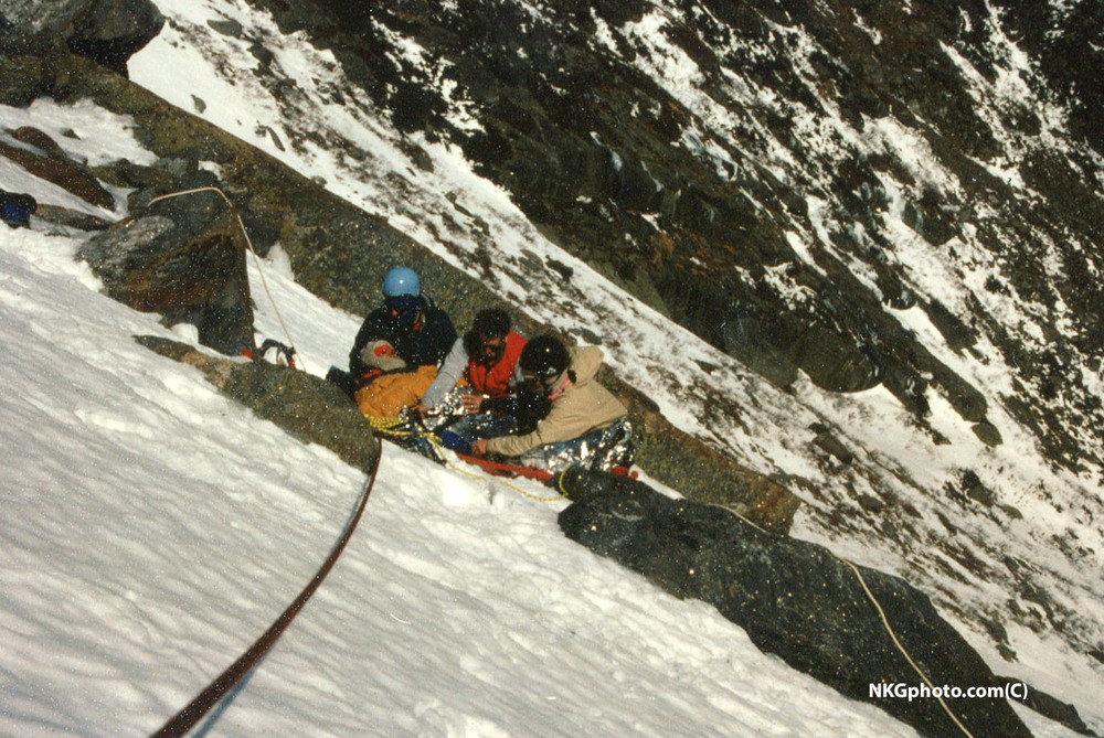
It took a lot longer to reach the Lion’s Head rock out-cropping than I had remembered. Between that first steep ascent and the Lion’s Head, there’s a good, steep stretch as you exit the trees. And there was more hard-going along the way, caused by more fresh snow, which we were constantly breaking through. By the time we reached the Lion’s Head, it was going on noon. Even if you take into account probably 45 minutes spent going almost up to the Fire Road, then doubling back to, and heading a bit into the Huntington Ravine Trail, then heading back up to the Fire Road, you’re still talking about 3.5 hours to get to this point. That’s probably almost 1.5 hours more than this should have taken, caused by having to break trail so much, and struggling up the first steep ascent. We were also now getting some significant WNW wind….I would guess constant 45-50mph. We paused behind the Lion’s head to get out of the wind, and also put on heavy gear. I had already donned my very insulated winter coat, and put my winter hat back on right as we were popping above the tree-line (below this point I had gone down to a moisture-wicking base layer and running fleece, and no hat, and was still sweating due to exertion). I also put on my Gore-Tex parka shell, which was essential protection from the wind at this point. Lastly, I switched from thick polyester gloves to poly liners and good, weather-proof mittens. The gloves I started with were now soaked and starting to freeze, as they had been repeatedly covered with snow due to having to use my hands so much below this point. My friends were in the same boat with gloves….we all changed out. They also put some hand-warmers in their gloves. It was bitterly cold at this point, and doing anything fine-motor skills-wise was extremely hard, with bare hands getting dangerously cold in just a minute or two. Regardless, we effectively switched out some gear, had a small bite to eat, and some water, and were in good spirits about making some good time to the summit, well before the forecasted sunset at 4:45PM. And an extra lift to our spirits was the sky……..it was as clear as crystal, and unbelievably blue. This was turning out to be easily one of the clearest days I have I have seen Mt. Washington. As we started around the Lion’s Head, we noticed that our two new friends who we broke trail for had made it up that first steep ascent, and were still ascending, but were moving slowly, a good distance behind. We continued along the stretch of trail right next to the lip of the Tuckerman Ravine, and it really was beautiful, and the going was actually not too hard….the wind was blowing hard here, and the snow was very much windswept from the trail, with cairns perfectly visible. But the wind was significant, and we were cold. Then we entered the Alpine Garden, and the mountain threw us the most significant curveball yet. Immediately upon entering the evergreen bushes of the Alpine Garden, it was obvious that the untouched trail was literally one huge snow drift. It was not possible, given the cold, to switch back to snowshoes at this point, and the only option was to trudge through. I broke trail the entire way through the garden in snow that was at least up to my knees, and frequently waist high. It was exhausting. I have no memory of how long it took me to move through the Alpine Garden in times past, but it’s not that long a stretch of trail. On this date, it was a real struggle, and I would guess that it took us 45 minutes. And frankly, my trail breaking didn’t make it that much easier for my friends following behind. At times, I was able to move kind of gingerly across some of the drifts, as it was crusty on top here and there. One of my friends is like 260 pounds. I swear he broke through with every step. I know it was awfully tiring for him. The snow drifts in the Alpine Garden were obviously due to the snow being able to pile up easily in the trail, protected from wind on both sides by bushes. And as evidence of this, the soft drifts pretty much disappeared as soon as we exited. But, despite being able to leave behind knee and waist-high snow, we now ran into what would prove to be the most significant problem of the whole climb…..the trail, as marked by the expected rock cairns, was no longer visible. We were not far from the base of the mountain’s cone, and even on this clear day, the rock cairns marking the trail were nowhere to be seen. It was pretty apparent that the snow was still deep enough, along with drifts, that the cairns had been essentially completely covered. Once out of the garden, the snow became extremely crusty, to the point that you could mostly walk across it without sinking in, but that was little consolation for not being able to see the trail. I tried the best I could, from memory, to re-locate the trail as we approached the cone, but I could not, and we were now faced with a very difficult choice: turn back, and immediately have to slog through the snow in the Alpine Garden again, then contend with the steep, windy terrain around the Lion’s Head, and then deal with a very steep descent right after, possibly in fading light, or……start up the frozen cone, and pray we were oriented correctly enough that we ran into Tuckerman Ravine Trail sooner rather than later. I decided to push up the cone. The one ray of hope here was that our current path, as we started ascending the cone, was not directly exposed to the very strong winds. And did I mention the day was absolutely beautiful to look at? It was hard to pause in a way that you could appropriately soak in the beauty of our surroundings, or document in photos and video, but the majesty of our location was undeniable. I figured at the time that breaking a new trail up the cone was going to be difficult and time-consuming, and that it was. It was steep, and it was exhausting, and additionally, there were times when we continued to break through some drifted snow. We had no choice but to identify what looked like logical, safe, less-difficult paths to do repeated switchbacks, as we zigzagged up the cone. I had basically given up on trying to find the Tuckerman at this point, and figured we were going to have to fully make our trail all the way up the cone. By the time we got what was probably three quarters of the way up the cone, which there was no way of knowing at the time, I looked, and saw that it was now approaching 3:00 PM. I actually started to worry at this point. I knew that, at best, we had barely 2 hours of daylight left. Also, our progress was very slow, and it was getting colder. I yelled to my two friends that it was critical that we made a really serious push, and we plodded on. At one point, just after this, one of my friends was ahead of me, and sat on a large, flat rock to take some photos and videos. I passed him, and a moment later he yelled out, repeatedly cursing. I asked what had happened, and he said that he took his mitten off to take the photos, and the wind blew it off the rock. I asked if it was far, and he said yes. It turns out that it initially dropped only about 20 feet away, but wind quickly picked it up, and blew it hundreds of feet down the cone. We weren’t going back for that, and now we were faced with a hand covered with only a thin liner. What a helpless feeling. Spoiler….his hand is still intact, and unfrozen, and he completed the climb with it in his coat pocket. As luck, or divine providence would have it, only about 15 minutes after my friend lost his mitten, I viewed a glorious sight…..the tops of two of the ice-covered towers at the summit of Mt. Washington. This was an indescribable relief. And as an special joke, probably only 10 minutes after that, we finally intersected with the Tuckerman Ravine Trail, and some large, fully-exposed cairns. We summited by 3:30 PM. The entrance area to the summit visitor’s center, which is normally partially-open as a shelter for climbers, was gated and closed. This is the first time I’ve ever seen this. I hope it’s not the norm now…it was incredibly disheartening. We actually also knocked on one of the exterior doors to the silo building of the observatory. My Dad had shown me this secret back in 1991, and at the time, some of the observatory staff happily welcomed us in, offered hot chocolate, let us sit down and warm up and pet their cats, and then be on our way, with well-wishes. On this day, a frightened-looking young man popped out of a door above me, on the roof, and asked what we wanted. It was windy and hard to hear, but I described our trials coming up the Lion’s Head, our pending hike down, the cold, and our desire to briefly get warm and regroup. He repeatedly stated that the visitor’s center was closed, and that staff was not supposed to let anyone in. I’ll let you draw your own conclusions about this interaction….all things considered. We got our must-have, quick summit sign photo, and set about getting off the mountain. Read on in the next post..... |
|
|
It was extremely windy on the summit. We were completely exposed to what I would guess were steady 50+ mph winds, and gusts of maybe 70mph. The air temperature was supposedly -5 to -8 degrees F. This puts the windchill in-between -30 to -40 degrees F. I had already planned to descend via the Mt. Washington Auto Road, as I’ve done numerous times before, for a number of reasons: there is no chance of losing a trail, no matter the time of day, there is nothing technical about it, and the views, especially of the Great Gulf Wilderness are otherworldly. The flipside is that you are above the tree line for a long time, and for the first roughly two miles, you are fully-exposed to any wind that is present. This was significant on this day. It was very difficult for those first two miles. I can’t explain the cold; I can only point to the weather stats I mentioned. It was miserable, and it got to be scary at one point: my glove liners had somehow gotten wet (sweat?), and the fingertips froze. I was unaware of this until I got my phone out to take a photo of all of us, and found I had some completely numb fingers. One of my friends had been using his left hand to shield the side of his head from the wind, and also now found that the joints in his wrist had become so cold that he could not move his hand. Thankfully, we both got to separating from wet gear, getting our problem areas in some dry insulation (mittens and coat pockets), and were able to thaw out while continuing to descend at a good pace. What a scary thing though. It took us just over 2.5 hours to descend via the Auto Road. Remember I mentioned that our friend turning back would prove to be fortuitous. Because he did that, we were able to arrange having him pick us up at the bottom of the Auto Road, as opposed to us having to hike back to the Pinkham Notch AMC parking lot, where we originally left our vehicle. My original plan was to try to take the Old Jackson Road from the Auto Road, back to Pinkham Notch. It’s good that we didn’t need to do this. In the dark, I struggled to find the trailhead for the road, and I can almost guarantee that we would have been in deep, unbroken snow the entire way, had we needed to take it. Alternatively, had we not had our ride, the only other option would have been to hike down Route 16, back to Pinkham Notch AMC. Both scenarios would have been awful, and the Old Jackson Road choice could have proven to be more than an inconvenience. Thanks to my friend who decided to turn back. After a quick visit back at Pinkham Notch to sign out and return the useless snowshoes, we headed back to Gorham and ate a lot of food. We also got really drunk the next night, after a day spent touring around the circumference of the Presidentials. The Town and Country had been invaded by a whole nation of snowmobilers, and the bar and restaurant there was hoppin’. We were semi minor celebrities as some of the folks found out that we summitted Agiochook in brutal weather the day before.
Some things that I consider valuable lessons learned from our climb (not necessarily new info for everybody, but some important things I learned, or was reminded of): -Air temperature, for the most part, is not as significant as people tend to think it is. You can function very effectively in sub-zero temperatures, with the right clothing. Wind is another matter entirely. Go look at a windchill chart. Even moderate wind can turn functional low temps into something very dangerous, or worse. -Sweat prevention is incredibly important. It was cold enough that, had I been any sweatier, I could have had body temperature issues at some point. You have to manage your layers in lower elevations. -You can’t wait to swap out wet equipment. Apparently wet gloves and wet socks can freeze fast. If they do, you’re probably past the point of effectively addressing it before your digits start to freeze. -You’ve got to be prepared to make contingency plans if one or more of your party cannot or will not continue. We got lucky. We weren’t high up. We were below the tree line. The path back for my friend was uncomplicated and direct, and he could safely do it alone. It could have been much different. If we had been above the tree line, we all would have needed to turn around. If we had been anywhere near or on the cone, it would have been a critical situation. Make good plans, and then make some more. -There’s a reason you don’t hike/climb in extreme cold in the dark. With no rays, it gets perceptively, dangerously cold, immediately. -Bring extras of essential things. We did. We could have used more….like at least one more pair of legit insulated gloves/mittens. -When things go wrong…don’t panic. Breathe deeply and slowly, come up with a plan, and execute your plan. Don’t stop and throw your hands up. I think we managed this part well. -Our electronics were not wrecked by the extreme cold. I saw no diminished battery life with my iPhone12, it did not mysteriously shut down at any point, and it continued to function in every way I needed to use it….photos, videos, phone calls, texts etc. My friend took many photos and videos throughout the climb, with no problems. However, both of the iWatches we had stopped tracking our hiking workout in the fitness app….though they continued to function in every other way.
I hope someone finds this helpful and/or entertaining. I’d love to respond if anyone has any questions or comments or suggestions. I’m sure I’ve forgotten something important. |

|
Sounds like a proper Northeast ass whoopin' :-) You should consider putting wrist leashes on all mission critical handwear, even if you have to sew em on. I have them on pretty much everything but fleece liners. And yeah, don't expect any help at the summit. Best to pretend those buildings don't exist in your planning. |
|
|
Great adventure. Summit buildings are off limits. You are choosing to play a silly dangerous game. It comes with silly dangerous rules. Wondering why you descended the auto road instead of back down lions head which gets you into the woods and wind shelter much faster? |
|
|
Nick Goldsmith wrote: It was a great adventure. Certainly a degree of danger involved. Every single climb, especially in the middle of winter comes with a degree of risk. "Silly"........that's certainly a matter of opinion. I don't find anything we did to be silly at all. As far as the buildings at the top go....I'm aware, of course, that the buildings are "closed" during the winter. However, every single time I've ascended in the winter, the "shelter" for climbers has been opened at the top. I don't think its unreasonable or foolish to have expected that it would have been this time. To answer your Auto Road question, as I mentioned, time and conditions were the determining factors. We would have still been breaking through drifted snow in many places all the way back to the Lion's Head. It would have taken a long time, and would have been exhausting. We then would have been descending very tricky, steep areas in the dark. It was definitely the correct decision to avoid that route back down. |

|
A lot of navigational errors can be prevented with basic map skills and taking advantage of the GPS capabilities of phones. Maybe you had one, but if you had a map and referenced it at those junctions, I think you could have stayed on track. Even better, don't completely rely on it, but take advantage of a GPS/mapping app on your phone. I use Gaia, there are others. Download Gaia and signup for the yearly subscription that allows you to download map sections for offline navigation. If used properly, having this tool would have eliminated your navigational errors on the lower trails. You just need to keep your phone powered (options: insulated pouch, heat packs, small battery bank) and always bring a paper map to augment and backup. Additionally, set some turnaround times and stick with them. I'm sure you felt pressure and excitement to summit, but turning around at Lion Head or during/after the Alpine Garden post holing would have been prudent based on the slow progress. |
|
|
Nice trip report. After reading the first post I thought there was 0% chance that your crew would summit. I’ve been in on Washington in similar conditions and almost certainly would have turned around after reaching the garden. Good on ya for pushing through and living to tell the tale. |
|
|
Brian Post wrote: Appreciate the suggestions. |
|
|
Cron wrote: Thanks for the props. Some of us need to step out onto the edge once in awhile. If you climb up there, I bet you know the feeling. Couple that with REALLY not liking to be defeated. Blame my dad….they’re his genes, and it’s how he raised me |
|
|
Andy. All of our climbing games have silly rules. It is what we do. I was always under the impression that there was no shelter on the summit in winter and that they would simply look out the window and watch you die. At least that's the way it is presented in my old Wilcox book. As for my question about the auto road I have never heard of a hiking party descending the auto road in winter? |
|
|
Thanks for the write up, really took me back and I appreciate the detail. I was also on that route in February 2010, zero Fahrenheit and 85 mph winds at the summit. We saw an EMS guide picked up and thrown by a gust of wind above the alpine garden. That day the entranceway to the shelter was open; we ate lunch (leftovers from Flatbreads) and warmed our hands for the descent. I got a terrible hamstring cramp breaking trail just above the outcrop. Big day. Good times :) :) |
|
|
Kalil Oldham wrote: That sounds great. I love that mountain. I wish there were more detailed accounts of winter climbs on it posted on forums. |
|
|
Nick Goldsmith wrote: Apparently these days they might very well look out the window and just watch. I know the Auto Road is a very uncommon path down for hikers, but it comes with its own adventure, and some tremendous views. I first descended it with my dad and one of my friends when I was 15, in 1991. My dad had used it to go both up and down the mountain at times, starting back in the 60s. |
|
|
I've always thought of that door to the observatory as similar to the hatch on that TV show "Lost. You know it's there but forbidden. I'm sure it's a stodgy New England thing and I'm not judging you but I'd rather die than rap on that door. Ha. Have fun. Keep after it. |
|
|
DGoguen wrote: Hahaha. I've got no shame. As I mentioned, we were so welcomed in years past that I thought it would be a cool treat for my friends, and give me a chance to relive a fun memory. Not so with the current crew, I guess. My dad, who's been welcomed in a number of times, and always let's everybody there know he is "a member of the observatory", was pissed. I think he took personal offense at us being snubbed. |
|
|
In the guy in the towers defense, I'd be pouring buckets of hot oil over to drive you away. Ha. Having a few random guys in to warm up isn't cool right now I wouldn't think. They have co workers with multi-day shifts to think about as well. |
|
|
We used to go up no matter what the conditions, even 100+ mph on the summit. We would go as far as we could, then turn back. Made the bad weather in April of 1980 on Denali seem mild by comparison. |
|
|
Andy. that decent of the auto road makes sense now. getting dark so you went the way you were most familiar and comfortable with. I have done the same thing up in smuggs. there is a long easy ish ice climb up there that has 3 finishes the longest finish by 70m being the middle one. I had soloed it and knew the way from there to the tricky to find rappel stations so the one time I guided it I took my poor friend the long way because it was getting late and it was the way i knew. the correct move would have been the much shorter right side finish. anyways it turned into a very long very cold decent in the dark ;) |
|
|
Sounds horrible. Hike or climb. Besides stealing warmth, it is a real challenge to stay upright and move with any efficiency once winds get going. Strongly suggest hand/foot warmers in those environments if you lack proper gear. Even with proper gear, electronic or exothermic body warmers can be a valuable backup aid, and essential in case of an emergency. People lose body parts in less demanding environments and manual dexterity can go out the window. And doing it all after a midnight shift at work? Crazy. |
|
|
the way they went up is a steep hike. there are many technical climbs up there. Its officially nasty weather. rescue I was on in 87
 |


