
 Continue with onX Maps
 Sign in with Facebook


Mt. Tom / Bishop -- North Ridge


|
Hey there: Looking for a partner interested in doing the north ridge route on Mt. Tom soon while it's still in snow. It's the imposing mountain above Bishop (directly above the Buttermilks). It's a walk-up w/crampons and axe for stability and maybe snowshoes if it gets soggy/warm. (Like Avalanche Gulch on Shasta.) 10 miles round trip. If we start just before dawn we can get up and down in one day even if we're slow. Here's a little beta on the route: https://www.summitpost.org/north-ridge/164852 Please be in touch if you're interested. I'm ready to do it in the next couple weeks. Looks way more interesting as a winter/spring climb than a summer hike. Best, Christian Kiefer |
|
|
 Note that I've already climbed like 2000 or 3000 feet. Also, I was just up around Whitney the last two weeks and the snow was very thin. The last storm dropped some more, but from pictures I've seen recently it was nothing epic. To me, if I was going to do it again I would assume two days. Day one, hike up to the ridge and go along it as best you can. Set up camp. Sleep. Day two, leave camp, summit, then head down. But I would reach out to someone in Bishop for more details. |
|
|
INYO COUNTY, CA, MARCH 10, 2021 – On Sunday afternoon, March 7, Inyo County Sheriff’s Dispatch received a SPOT notification from a hiker requesting assistance for her hiking partner who had taken a 40′ tumbling fall on the north ridge of Mt. Tom at approximately 12,000′. The subject was experiencing acute back pain and was […] That took two days of choppers being blown off Tom & a very experienced rescue team being turn around the first day to get to them. |
|
|
attempted a one day acent of the north ridge on sat. Made it about half way and turned around. Yolo is correct about the terrain bushy and rocky not supper easy in winter. recommend snow shoes for the upper ridge, no crampons, no skis, no ice axe. Also I would go back. |
|
|
I can't figure out if these posters are just trying to be helpful or to talk you out of it. Sounds like an adventure, Christian. |
|
|
It’s a 2 day deal in the winter unless you have legs like tree stumps. |
|
|
A little history of the first winter ascent of the north ridge of Mt. Tom: http://sierrapeaks.org/archives/sps00490.htm If you are interested in the summit of Mt. Tom with a bit of the ridge, probably the easiest way to get there in winter is up Elderberry Canyon with skiis or snowshoes. You'll hit the ridge closer to the top and don't have to deal with that super loose sandy shoulder. During the Fall I went partway up the north ridge and it was probably the slowest I've ever made vertical progress outside of aid climbing :P Keep an eye on avalanche risk there though, as people have died skiing Elderberry Canyon. |
|
|
Thanks all. Good to get these perspectives. I'm aware of the wind, avi danger, etc. It didn't look like there was a great amount of snow up there at this point--at least from Bishop--but I expect cornices from wind. Was planning on axe and crampons for any wind-scourced/iced-up sections but sounds more like snowshoes on the upper side. May need to re-visit the plan given this beta. All much appreciated. |
|
|
FrankPS wrote: Hey I'll take both! It's good to know what I'm getting into and the recent problems help a lot with the beta. |
|
|
Ben Horowitz wrote: Looking at the topo: So Elderberry connecting to the North Ridge at something like 12K feet? |
|
|
Christian there isn’t a ton of snow up there, just enough the make travel slow. |
|
|
Having done the N. Ridge in winter, I would recommend the following:
Have fun! |
|
|
Christian Kiefer wrote: Yeah, although from the top of Elderberry Canyon one can also just boot straight up the headwall and be much closer to the summit, but that looks steep and scary to me. Looking at pictures it seems like at a certain point the path of least resistance would be to go climbers right at the top of the canyon, connect with the ridge, and then zag back over the headwall to get to the summit. I think this is the common approach done by people who want to tag the summit when skiing the canyon itself (particularly if you don't want to ski the much higher-consequence headwall section). |
|
|
Slog! Up and down. Looks pretty but just a freaking slog. Edit: find your worst enemy and pay them $200 to do it. |
|
|
Mark Frumkin wrote: hmmmm... yep, the (very experienced) sar turned around that first night - BUT the HUSBANDS made it! |
|
|
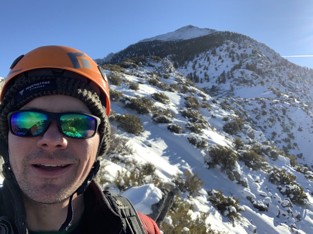
Christian Kiefer wrote: oh boy, that's pretty tempting... 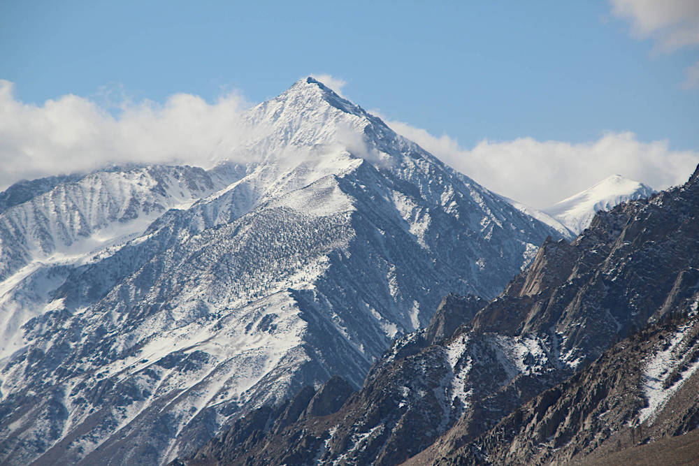 pic from a couple of days ago. i was playing around up there on a photo mission a few years ago, made it to the trees before i turned around. a few random takeaways: - i would rather go now vs. later in the season (which is what i did). hopefully the sand is packed down a bit at the start, it's pretty woeful when it's loose and eats up time and energy. as others have mentioned: it is a SLOG (but the view of pine creek is bar none). - many ways to pick your way up to the ridge at the start. be sure you can find your way back to the car when it's dark. - be fit AND acclimated if you're shooting for IAD. reality is quite different from what stuff looks like on paper. - i would bring a stove and emergency bivy gear and not count on making it up and back in a day, even though i believe i can. with a stove you can go easy on h2o weight at the start, you come out ahead in terms of weight and energy saved (and have more utility). - that ridge is really windblown, which could be bare, thin/hard crust, and deep powder. lee vining canyon (ice) had 6" to more than a foot of fresh powder a couple of days ago - peter and lisa skied, my buddy doug had snowshoes, i postholed most of the end. some light crampons and snowshoes could make the difference between making it and turning around (or getting rescued). - don't go on a windy day - almost at my turnaround point, i heard a noise below me on the ridge. there was an adult bear, running full steam (fortunately down) the ridge. it was amazing to see how fast it made it through the bushes and around the rocks. i felt VERY small. no chance if that thing comes running at you - NONE... good luck ;-) |
|
|
old5ten wrote: That picture you posted reminds me of how big the ridge really is. That false summit in my pic is still really far from the summit. Of course if the conditions open up it would be easier. I still think two days would be appropriate for most folk. I sort of want to go do this myself now.. I am curious how the husbands made it up there... I feel like details are missing from that article. |
|
|
YOLOLZ Bicarbonate wrote: not sure if you're married, but if your other half is out there you're going to get there or die trying. sar is limited by rules (ie not creating more victims, etc.) |
|
|
So I ended up not doing this because so many people told me it was boring/a slog. Tried for Emerson today but alas too much snow to safely do the chimney solo. Will wait and round again in a month or so. |
|
|
Way to get out regardless, Christian! I'd offer, there's nothing wrong with starting up something huge and turning around if it doesn't work out. Dreaming big is fun and failing (SAFELY) ain't so bad. A less committing winter ascent of Mt Tom may be had on the other side. You can hike the mining road up Horton Creek. Even Booter the amazing mountain dog can do it! 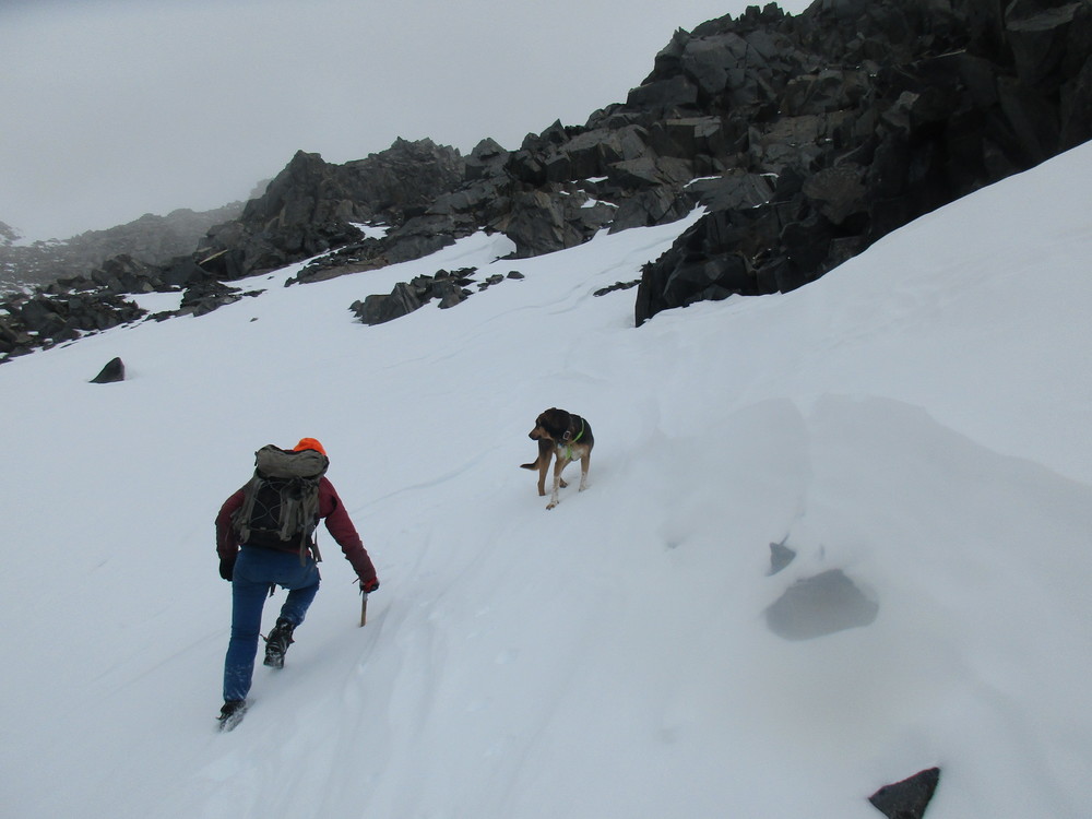 I have mentioned this elsewhere, but my all-time favorite early season climb is the northeast couloir on Mt Langley. Here's to all you sloggers out there, I tip my postholed snowshoes to you.  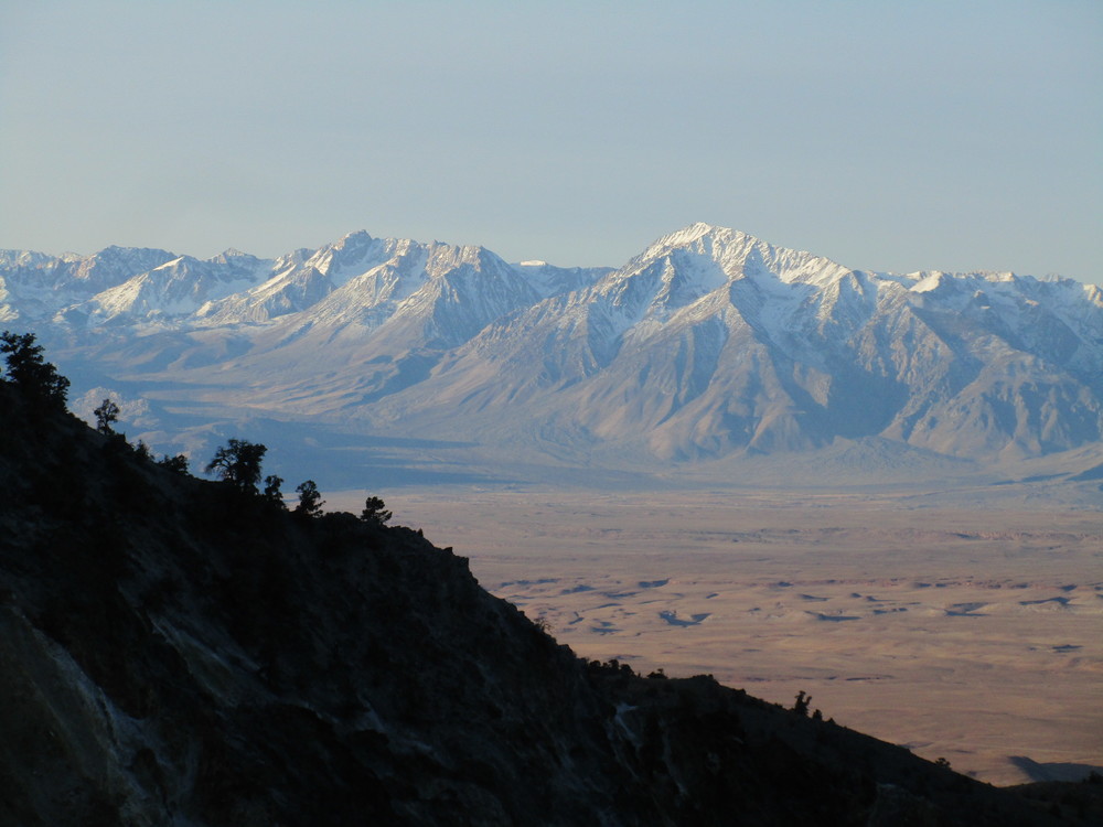 |
|
|
NE couloir of Langley is fun. And you can chill at the ashram on the way up. Picturesque spot to down some edibles if inclined. |


