
 Continue with onX Maps
 Sign in with Facebook


Does Horse Flats “area closed” mean closed to climbing?
|
|
Please pardon my ignorance. The NP website says the Horse Flat “area” is closed, but I wasn’t sure if this meant the campground is closed, or if there is no climbing allowed either. TIA! |
|
|
My understanding is it means the campground is closed. Climbing should be okay. |
|
|
Anyone know how the area fared in the Bobcat Fire? My understanding is that some of the area around Chilao burned. |

|
 |

|
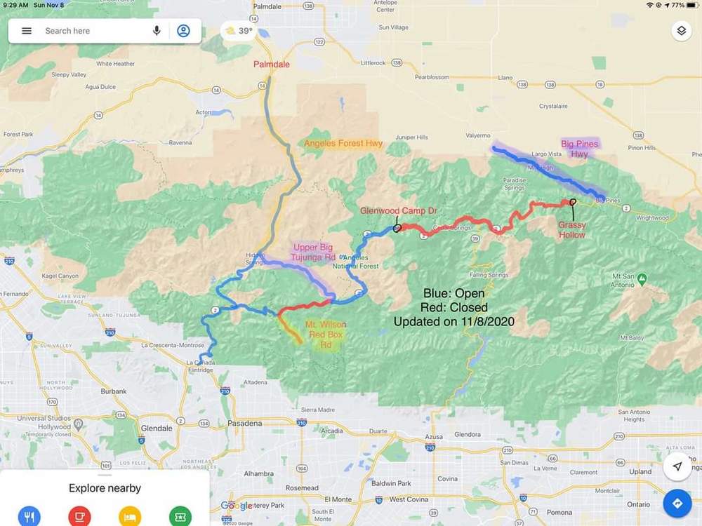
It seems like the wilderness is open where the boulders are in the new closure map, but that the hwy 2 closures occur twice before you get to the horse flats entrance.. maybe there is a paved way around slightly north (seems to work via google maps) or maybe it is dirt / FS roads. I have been wanting to get up as well, but remember one of the original orders closing things until April 2022 !! Horse Flats seems to be right on the edge. Temps are primo but I bet big burn scars are visible from there now. Elliot / Mike maybe a phone call will give more info. interested to hear. |
|
|
 |
|
|
You can get there, pretty sure you have to walk from upper gate though. |
|
|
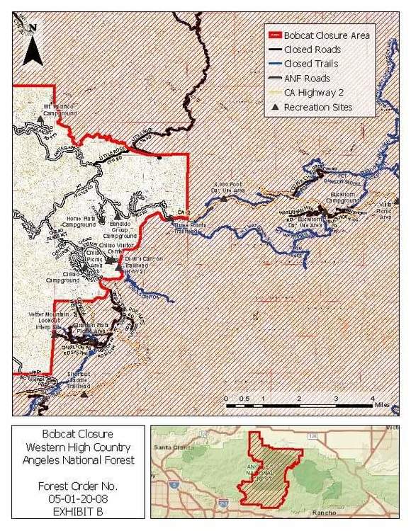
Beautiful, David.. Thanks for the detail map. |
|
|
I pulled this off the HWY 2 Facebook page, whoever runs that and the Angeles National Forest page have almost real time updates on the HWY/forest conditions. |
|
|
Here's what Caltrans reports as of today. I don't know how far Santa Clara Divide Rd. is from Newcomb's Ranch, but it's less than 3.3 miles then you're good. This highway information is the latest reported as of Friday, November 13th, 2020 at 01:22 PM. SR 2 [IN THE SOUTHERN CALIFORNIA AREA] IS CLOSED FROM 3.3 MI EAST OF NEWCOMB'S RANCH TO ISLIP SADDLE (LOS ANGELES CO) 24 HRS A DAY 7 DAYS A WEEK - DUE TO A WILDFIRE CLEANUP - MOTORISTS ARE ADVISED TO USE AN ALTERNATE ROUTE IS CLOSED FROM THE JCT OF SR 39 /AT ISLIP SADDLE/ TO VINCENT GULCH RD /IN VINCENT GAP/ (LOS ANGELES CO) - DUE TO WILDFIRE CLEANUP - MOTORISTS ARE ADVISED TO USE AN ALTERNATE ROUTE IS CLOSED FROM 5 MI WEST OF BIG PINES TO 2.7 MI WEST OF BIG PINE /AT GRASSY HOLLOW CAMPGROUNDS/ (LOS ANGELES CO) - DUE TO ADVERSE WEATHER - MOTORISTS ARE ADVISED TO USE AN ALTERNATE ROUTE CHAINS OR SNOW TIRES ARE REQUIRED FROM 1 MI EAST TO 3 MI EAST OF NEWCOMB'S RANCH (LOS ANGELES CO) PLEASE RESEARCH CHAIN CONTROL LOCATIONS AS CALTRANS IS CURRENTLY WORKING TO UPDATE CHAIN CONTROL DESCRIPTIONS FOR CONSISTENCY WITH INTERNET MAPPING, LIKE GOOGLE MAPS & MAPQUEST. 1-WAY CONTROLLED TRAFFIC AT VARIOUS LOCATIONS FROM 14.6 MI EAST OF LA CANADA-FLINTRIDGE /AT UPPER BIG TUNJUNGA RD/ TO THE JCT OF SR 39 /ISLIP SADDLE/ (LOS ANGELES CO) 24 HRS A DAY - DUE TO WILDFIRE CLEANUP - MOTORISTS ARE ADVISED TO USE AN ALTERNATE ROUTE ALL TRACTOR-SEMI TRAILER COMBINATIONS WITH 3 AXLES OR GREATER ARE PROHIBITED FROM THE JCT OF I 210 /IN LA CANADA-FLINTRIDGE/ TO THE ANGELES FOREST HIGHWAY (LOS ANGELES CO) - ALTERNATE ROUTES ARE AVAILABLE |
|
|
Has anyone been up there recently? |
|
|
Went up last Saturday 6:30 - 9a by myself, was relieved or downright overjoyed? To see that most of the fire damage was not anywhere near the actual Horse Flats area... totally untouched (even though it was within the burn boundaries)
Go get it and enjoy before the upper gate closes for winter ! And then bring your bike : ) |
|
|
Colin Sander wrote: Thanks for the update! |


