
 Continue with onX Maps
 Sign in with Facebook


Deciding whether or not to boulder in smoke
|
|
With the horrific fires on the west coast I'm having a hard time deciding some days whether to climb or not. I'm relatively healthy, 33, and live in Truckee. The maps the last few days have gone between yellow and red (AQI 50-200) and aren't 100% accurate. I'm bouldering so maybe not breathing as hard for as long as someone on long routes, but how do you decide whether to climb or not each day? This morning the maps said about 150 but it looked okay outside my house, then as I drove on the highway it looked pretty bad and I turned around and came home. Would love to hear how others think about this or good research to help guide my decisions. Thanks! Nathan |
|
|
This article gives a few metrics. https://www.climbing.com/news/is-it-safe-to-climb-outside-when-its-smoky/ I judge if I'll climb by how smoky it was last night, if it smells like a campfire in the morning (no go for me) and how much visibility there is. |


|
If there is any doubt, there is no doubt. |
|
|
My wife and I hiked in Colorado in mid-August, often at altitude. We avoided the worst of the smoke, but definitely got whiffs of campfire air on several days. We definitely had a bit of that "hangover effect" talked about in the climbing.com article for a good week after we got back. As much as it sucks, I'd probably try to stay inside if I lived in the area and wasn't trying to make the best of limited vacation. |
|
|
MY AQI has been around 500 recently. I want to go climbing so bad, but I'm holding off. :/ Can't even boulder next to the ocean it's so smokey. |
|
|
Stiles wrote: This is a good way to think of it. Like you, here in CO we were dealing with smoke for the last month. Much of it from local fires, some of it being looped around from California (YOUR smoke!). The consensus out here was that getting smoke particles in your lungs wasn't worth it. The worst ones are the ones that can pass through an N95 mask. Boulder indoors if you can. Here's a good resource. https://hwp-viz.gsd.esrl.noaa.gov/smoke/index.html# It uses satellite data and creates a short-term forecast. Click on "Near Surface Smoke" and you'll get a map like this one from this morning. You'll need to be patient, the site is getting hammered. "Z" means zulu time, subtract 7 hrs for CA. 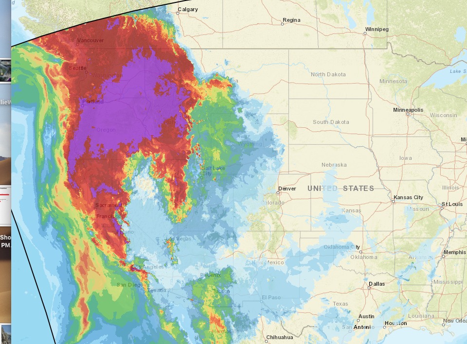 |
|
|
Thanks! Precaution makes sense and the articles and websites are useful. Will hold off. |
|
|
Bust out your finest Chinavirus N95 respirator. |
|
|
I've been using the Mount Tom Index. If I can see mount tom from town relatively clearly, I'll hit up the tablelands after work. If it's a little blurry or completely obscured I'll just take the dog for a walk. It might be a little harder to see mount tom from truckee... |
|
|
Love it ;) great index. |
|
|
fire.airnow.gov has been really helpful for me recently to determine if I want to go out to hike/bike/climb. Many times there is also a brief write up for areas to let you know the daily outlook. |


