
 Continue with onX Maps
 Sign in with Facebook


Draper City closing Upper Corner Canyon Road July 1, 2020

|
Starting at the Orson Smith Trailhead vehicle access will be restricted beginning July 1, 202 per Draper City & Draper City Fire Department. |
|
|
I've been wanting to try the Alpine approach in the summer. |

|
The Alpine approach was the de-facto standard for decades til the road got closed off. Last few times we just parked at the next to last switch back and walked from there. Takes about three hours to get into the Cirque. Some water along the way. I always found it to be a nice walk. If one has to park lower down there is a bee-line trail from the first switch back. The last time we did it as a day trip, did Triple Overhands and Vertical Smile and still had plenty of day light left when we got down. |
|
|
Alpine trail is better IMHO. I took it the last two trips up this season. The only shorty part is when you leave the trail and follow the drainage until you start the traverse west to wrap into the cirque. Other than that, Quite pleasant for a Cirque approach. |
|
|
Anyone done the cherry creek logging trail approach? I was thinking of checking it out anyways this summer. |
|
|
I just threw up in my mouth imagining carrying climbing gear up the Saw Mill Trail.....that’s the last way id get there. |
|
|
Allen Sanderson wrote: The Alpine approach was the de-facto standard for decades til the road got closed off. Last few times we just parked at the next to last switch back and walked from there. Are you starting at the schoolhouse springs trailhead? |
|
|
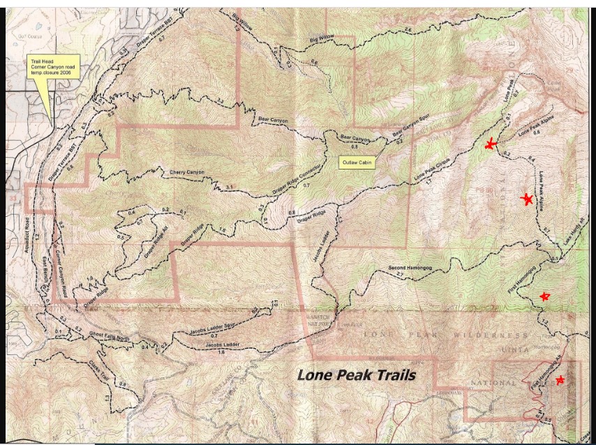
We did Cherry Creek last year. It was fine as far as Outlaw Cabin. We made the mistake of staying on it and wound up way high on rim of Cirque after many hours of threading our way over granite ridges. It was awful and don't recommend unless you can find your way from cabin to Cowboy camp. We just did Jacobs from Canyon Pt. Road. They are building a new trailhead there but as of now you have to park on street, outside of no parking zone. I think it saves a mile off of Ghost Falls. |
|
|
shredward wrote: At this point I would assume yes, as it has been a while since I have been there. If the gate is open then one can drive up the road a ways. In recent times I have heard the gate was closed and locked. |
|
|
Planning on heading up to lone peak but I’ve never taken the alpine approach and can’t find much beta. My preferred method is to start the hike after work and knock out as much as possible, bivy, and hike the rest in the morning. How difficult would route finding be on the alpine side in the dark and how easy is it to find a decent bivy spot? Does anybody have a gps map of the route for reference? |
|
|
From the Alpine side if you head up in the evening it’s pretty easy to follow the old road to the first hamagog then follow the trail heading west-northwest out of the first hamagog to the second hamagog. The second hamagog is a great bivy spot and there is a spring on the north side of the meadow that “normally” has good water. In the morning you head up the steeps and around into the cirque. |
|
|
Thanks for the beta! Might end up doing that, a change of scenery wouldn't hurt. When you make your way up from the second hamagog do you end up having to take the ramp down to the raps or can you wrap all the way around directly in to the meadow? |
|
|
The Alpine approach requires hiking basically straight up to the circ's south side from Hamongog #2 and then trending west ALL THE WAY AROUND to the front (west) side of the circ....and then into the circ. Hope that helps. |
|
|
Driving up to the first hamongog in my friends 4runner was the scariest drive of my life. He was a shit driver and I remember walking down part of the way. Those days were awesome. |
|
|
For day trips it is common to gain the Collins Highway notch, drop your pack and then climb. Not sure why you'd want to curl around the hyperform wall unless you were going to camp in the meadow. |
|
|
 https://cdn2.apstatic.com/photos/climb/106504615_large_1494115138.jpg |
|
|
Grug, correct. |


