
 Continue with onX Maps
 Sign in with Facebook


USGS Topo Map Reading - Public vs. Private Land
|
|
I am new to reading USGS Topo maps and am having a hard time differentiating between land designated as public and private within the boundaries of Wayne National Forest in Southeast Ohio. The park is administered by the US Forestry Service and they offer updated topos of the park every so many years. Wayne has quite a bit of private land within the park's proclamation boundary and I want to ensure I'm not trespassing on private property when I roam the woods. 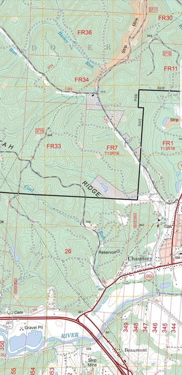 |
|
|
I'm in Montana and deal with a patchwork of public and private land for work, recreation, and hunting and fishing. I use an app, OnX, developed by a company in Missoula, MT, primarily for hunters, but useful for anyone. It is inexpensive, data is available for all other states, and it is useable offline/with no cell service. It even identifies private land owners so that you can contact them to ask for access. |
|
|
Caltopo has a land management overlay, though i've never tested how reliable it is |
|
|
Andrew Rational wrote: I'm in Montana and deal with a patchwork of public and private land for work, recreation, and hunting and fishing. I use an app, OnX, developed by a company in Missoula, MT, primarily for hunters, but useful for anyone. It is inexpensive, data is available for all other states, and it is useable offline/with no cell service. It even identifies private land owners so that you can contact them to ask for access. +1 OnX is amazing. |
|
|
You can also use the USFS's and the state/county's online parcel ownership maps, if they exist. |
|
|
Caltopo is my go to, green overlay is USFS boundaries. 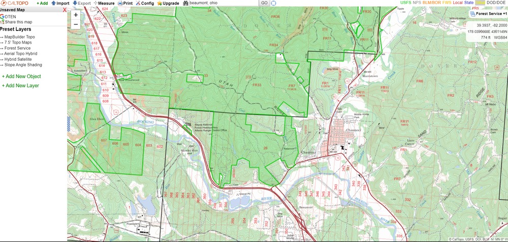 |
|
|
Matt Castelli wrote: You can also use the USFS's and the state/county's online parcel ownership maps, if they exist. I do often use Montana Cadastral, which is free, but only works with a data connection, and doesnt track my location in the field. It is also clunky on mobile devices. I also just thought of something else for OP. A company in Billings, MT, MyTopo, will print custom maps, with custom overlays like topo lines, aerial imagery, and land ownership demarcations. I have a 5' x 8' one for my immediate area, and I consult it frequently at home, but it isnt particularly useful in the field. |
|
|
David Tennant wrote: Caltopo is my go to, green overlay is USFS boundaries. Another resource is https://maps.usgs.gov/padus/ (Protected Areas Database of the United States). Caltopo's support page says that their data comes from the BLM Surface Management Agency dataset, which looks like it's the same underlying data. Caltopo may be more convenient because they now have a mobile app with offline downloads.  |
|
|
Caltopo app? Any tips for finding it - App Store isn’t doing the trick |
|
|
Matt Castelli wrote: Caltopo app? Any tips for finding it - App Store isn’t doing the trick The iOS app is still in beta. You can use the app TestFlight to try the CalTopo beta version out. |


|
Matt Castelli wrote: Caltopo app? Any tips for finding it - App Store isn’t doing the trick GaiaGPS can load Caltopo data. |
|
|
Matt Castelli wrote: Caltopo app? Any tips for finding it - App Store isn’t doing the trick Matt, Caltopo is best use on a desktop computer with a large screen. They do have a mobile app in beta testing, but the browser-based software at Caltopo.com rocks. Use the "Land Management" overlay to show federal and state land ownership in the United States.In the example below for Crater Lake in Oregon, clicking that overlay shows the Forest Service land with a green tint that surrounds the National Park, which can be a good way to find stealth camping spots next to national parks, hint hint. =^) The whole procedure is covered in detail here: https://www.alpinesavvy.com/blog/how-to-find-free-dispersed-camping-on-public-lands 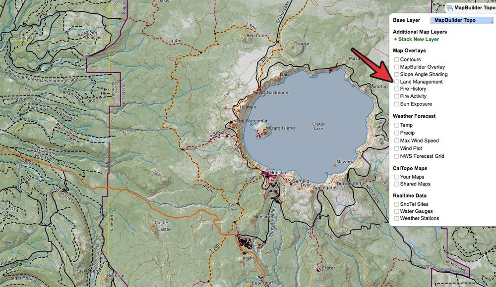 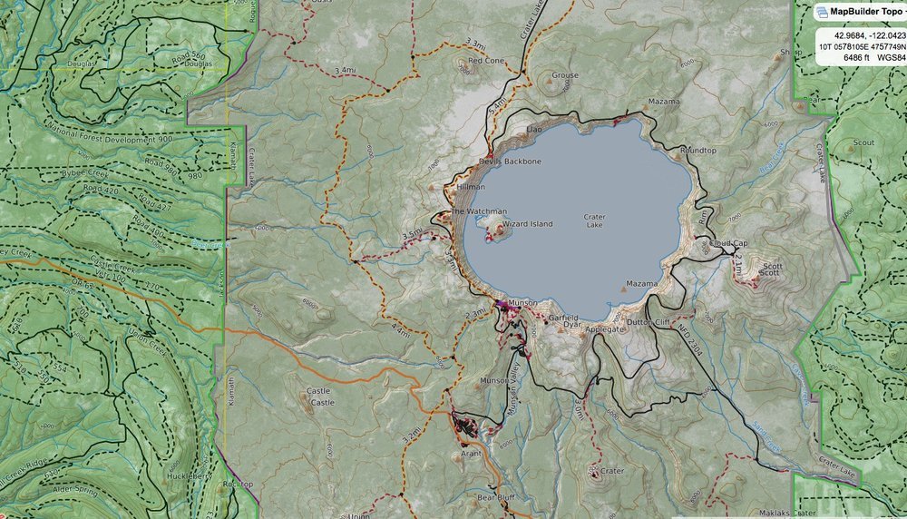 |
|
|
When looking at a USGS map in general inholdings (private lands with the National Forest) will be shaded a different color. In the map shown there are five inholdings. One by the word "Ridge" and two just above in the shape of a bow tie. And two more along the road. |
|
|
And don’t forget if you’re reading a paper map to look for the date on the map. Many of them are marked 1954 or whatever. That’s the last time the map was updated. Hell, Mountain Village, Eagle, Snowmass and Keystone didn’t elevate exist in 1954! |
|
|
John - well aware of the browser version, just looking for phone app tips like Luke and Senor gave. Interested in that camping around Crater Lake tho! |
|
|
Gaiapgs has a nice public land layer that you can set the transparency of. I place the public land layer on top of the map i am interested in and set the transparency to 50%. This makes it easy to see what's what. |
|
|
Look up the recreational use statutes for your state. In many states, recreation is permitted on private land if it is not posted as "no trespassing" according to whatever definition of that is used by your state. You might not need to worry about it at all. |


