
 Continue with onX Maps
 Sign in with Facebook


App to turn smartphone into sat phone


|
On my drive to work this morning I was thinking about getting an inreach for an upcoming trip to Mt Slesse. Not that remote, but some objective hazards and there’s probably no cell service out there. And an inreach is always just nice to have. |

|
I've been missing out... |
|
|
Nick Niebuhr wrote:....But then I thought, my phone connects with satellites for the gov to track where I am at all times, I wonder if it could connect the same way as a sat phone for emergencies??.... a smart phone not connected to a cell network (ie in the backcountry or in airplane mode) doesn't transmit any data about its location. it receives pings from satellites and uses the relative distance to multiple satellite points to triangulate your position. this explains why your phone's power usage is so much more efficient in airplane mode even when you're running a gps app in the background. it isn't transmitting any data (except maybe bluetooth, but that's extremely local). an educational pdf about how gps works courtesy of the govt |
|
|
brian burke wrote: Thanks for the info. Then how does a satellite phone or InReach work? Is it able to send signals to a satellite, like (I'm guessing) a cell phone does with cell towers? If that's the case, then that shoots down my idea pretty quickly. |
|
|
Nick Niebuhr wrote: Yes. Satellite phones and inreach send signals to satellites. |
|
|
how a sat phone works
essentially it is just able to send and receive a signal significantly farther than your phone can (which only typically connects to a tower within 50ish miles). If you are looking into InReach, I would highly recommend. Super nice to be able to receive messages as well as send, makes communication not feel like throwing a message in a bottle. |
|
|
All of the emergency satellite beacon devices connect to one of three satellite constellations: Globalstar, Iridium, or maybe Orbcomm. Connecting to a satellite (>300 miles away) takes a lot more power and a lot better antenna than connecting to a cell tower (<10 miles away usually). So a cell phone doesn't have the necessary hardware to connect to a satellite. |
|
|
The inreach mini is fantastic. I just used it on a 35 day, 8000 mile off-road motorcycle trip cross country. It pinged my position up to the sky-birds and hence to my personal webpage, every 10 minutes allowing anyone who had access to my webpage to follow my movement in almost real time. The satelite text messaging function worked very well. All of my text messages went through although there was some variation in upload speed depending on overhead cover but it never took longer than a few minutes. People who I had given my inreach contact number to could also text me. Those also always came through. Luckily I never had to use the SOS feature but based on the 100% texting success I am fully confident it would have worked if needed. Great device. |
|
|
Yes you can get an app for this. |
|
|
The SpaceX network is being built, some of it will go online in 2020-2021, satellite internet with faster latency than fiber. There will be global coverage soon, and cheap. I can't wait. |
|
|
gtluke wrote: The SpaceX network is being built, some of it will go online in 2020-2021, satellite internet with faster latency than fiber. There will be global coverage soon, and cheap. I can't wait. At last! Elon can finally watch me crush that pink 9 in the corner |
|
|
Cooper - wrote: All of the emergency satellite beacon devices connect to one of three satellite constellations: Globalstar, Iridium, or maybe Orbcomm. Connecting to a satellite (>300 miles away) takes a lot more power and a lot better antenna than connecting to a cell tower (<10 miles away usually). So a cell phone doesn't have the necessary hardware to connect to a satellite. Nice info. Wonder why they haven't made a cell phone with the necessary hardware yet. Some people need it. |
|
|
Jason Smith wrote: People who need one buy or rent a sat phone. And even then they don't work that great. The necessary hardware is expensive and somewhat bulky, which is why it doesn't come as standard issue cell phone equipment. |
|
|
After being unable to work my way through he deep woods to an unclimbed cliff twice, I got the Gaia app. Basically it will pinpoint your location via gps satellites and you can switch from topo to google satellite. It's awesome. I will note that the USGS topos do not show all the cliffs one will encounter out there and I learned that the hard way, so be cautious. I suspect there are other features I don't use, I barely have this figured out. You still can't call anyone out of cell range. |
|
|
Billcoe wrote: GPS also gets pretty squirrelly in proximity to cliffs and canyons because you're getting very restricted satellite connection. Just last week I sat still and watched my location bounce all over a canyon according to my GaiaGPS-running phone. Green line in this photo is me. I wasn't actually running around like that. Just sitting by the creek. 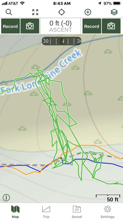 |
|
|
Señor Arroz wrote: That's actually pretty good for GPS in a mountain environment, and plenty accurate if you are trying to tell someone where you are |
|
|
I had a sat phone for years because I needed to be available for work and wanted to still get out on trips. It sucked. It was the Globalstar system which is low-orbit satellites, which means they are travelling across the sky at a relatively fast speed, which means calls are dropped and you need to wait for another satellite to come along. Theoretically they say there is enough satellites that this doesn't happen, but it happened all the time to me. When you are on a conference call and most participants think you are in an office and you disappear for a while - well that just doesn't work. The Iridium network is better because the satellites are geosynchronous, which means they match the rotational speed of the earth, which means relative to us they are stationary. However, this also means they are much further away and there is some latency, or time lag when talking. Sat phones are good for emergency work, but the texting capability of Spot or Inreach work really well for that too. |
|
|
Ney Grant wrote: It was the Globalstar system which is low-orbit satellites, which means they are travelling across the sky at a relatively fast speed, which means calls are dropped and you need to wait for another satellite to come along... The Iridium network is better because the satellites are geosynchronous, which means they match the rotational speed of the earth, which means relative to us they are stationary...You're correct that the Iridium network is generally more reliable than the Globalstar network, but not for the reasons you've stated. With Globalstar, a message can only be transmitted if the portable device (satellite phone or Spot) and a Globalstar ground station are in view of the same satellite. There are 44 active satellites in low-earth orbit (1,400 km above ground) and 24 ground stations. If a satellite doesn't happen to be in the right position relative to both you and a ground station then nothing will be transmitted. That's why Globalstar doesn't work in mid-ocean, for example. Also, Globalstar orbits don't provide polar coverage. Many Denali climbers have learnt this the hard way. Iridium satellites are also in low-earth orbit (700 km), but the big difference is that Iridium satellites can transmit messages between each other. It doesn't matter if the satellite in view of your device isn't also in view of a ground station; your message will be bounced between satellites until it can be transmitted to the ground. There are 66 active Iridium satellites and each satellite can communicate with four others. Iridium orbits provide true global coverage. Neither are geo-synchronous. A geo-synchronous orbit is about 36,000 km. |
|
|
You're correct that the Iridium network is generally more reliable than the Globalstar network, but not for the reasons you've stated.Thanks - I'm not sure where I got that erroneous info but thanks for the correction! |
|
|
Ney Grant wrote: Thanks - I'm not sure where I got that erroneous info but thanks for the correction! Inmarsat is in geosynchronous orbit and has a phone service. |
|
|
So the MountainProject Wunderkind have thoroughly explained how an app alone wouldn't suffice to do what you want to do, but that begs the question: I wonder if it might be possible to create an app + accessory for a smartphone to transmit to a satellite? The power requirements would be much larger, but if you weren't making an extended call, and simply needed to transmit a distress signal and your position, I bet it could be done with the phone's internal battery.. |


