
 Continue with onX Maps
 Sign in with Facebook


GPS Tracks for the Eiger and Mt. Blanc?


|
Hi All, |
|
|
I do not, but Trois Monts is trenched the entire way and easy enough to follow, provided you have the weather to climb. The climb off Maudit is a bit spicy now; some anchors set to rappel. There was also a fixed line on Tacul. |
|
|
Courtesy of Ueli. Good luck, stay safe, and take a moment to enjoy it for him! |
|
|
Tres Monts is might not be advisable now, due to serac fall on the north face of Mont Blanc du Tacul. Search for the "La Chamoniarde" page on Facebook. |
|
|
Peakbagger might be helpful with these |
|
|
From yesterday: Une chute de séracs a aussi balayé la face N et la trace de la voie normale du mont Blanc du Tacul (itinéraire du mont Blanc par les Trois Monts). De visu, la zone semble encore instable. Cela a considérablement compliqué le cheminement dans la face et notamment le franchissement de la rimaye. Translation: A fall of seracs also swept the North face and the normal route of Mont Blanc du Tacul (route of Mont Blanc by the Three Mountains). Visually, the area still seems unstable. This has considerably complicated the path in the face and in particular the crossing of the bergschrund. Link to photo of serac fall on MBdT: https://www.facebook.com/chamoniarde/photos/pcb.2570651309658019/2570632422993241/?type=3&theater |
|
|
Thanks all for the leads, much appreciated. I'll scour PeakBagger and Movescount; thanks for the heads-up on serac fall on Mont Blanc du Tacul, too -- it has been a heck of a hot summer. |
|
|
Gerrit Verbeek wrote: Courtesy of Ueli. Good luck, stay safe, and take a moment to enjoy it for him! It doesn't work on garmin.Gpx files are empty. |
|
|
Bogdan Pop wrote: The GPX files are fine and have data in them but I have a Garmin 64S and I think I know what you're talking about. I'm not 100% sure what the issue is but sometimes Garmin devices seem to not know how to interpret tracks without timestamps (they differentiate between Tracks and Routes, where a Track needs time data). I'll mess around with it in Basecamp in a few hours and re-upload.  Edit: While I'm at it I can check Suunto too for other routes. They appear to have extensive tracks in the Alps (more show up as you zoom) and even have a Mountaineering category.  Edit 2: Trois Monts traverse by Txintxu, "3 MONTS BLANC TACUL GOUTER" http://www.movescount.com/map?route=4771315&lat=45.85336650000002&lon=6.84288250000003&zoom=14&activity=999&style=suunto-offroad Trois Monts out and back by Thibault_BARRON, "3 MONTS" movescount.com/map?route=47…;lat=45.85637362322612&lon=6.877928378457312&zoom=13.99767321989661&activity=999&style=suunto-offroad Neither of those seem to tag the summits of Maudit or Mont Blanc de Tacul, but I don't know the routes at all |
|
|
Final result: Converted track uploaded here https://drive.google.com/file/d/1bhMJ48rnJrGGWDDJJc-sMwSzKq-fbIlp/view?usp=sharing
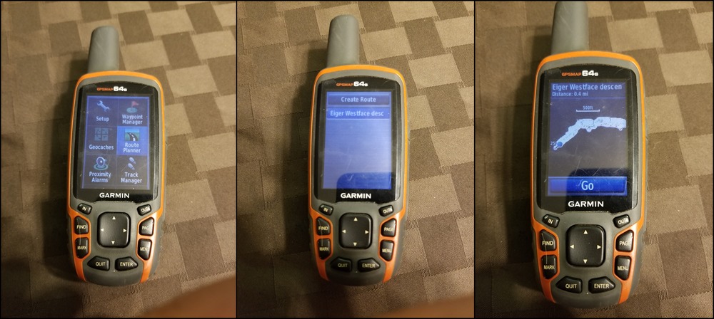
Find and replace: <rte> with <trk> </rte> with </trk> <rtept> with <trkpt> </rtept> with </trkpt> Add: <trkseg> after </name> and </trkseg> before </trk> Hooray, it now shows up in my Tracks as a clean line!  |
|
|
Great work Gerrit Verbeek ! |
|
|
Seems all track links are broken in thus thread including Uli's. |
|
|
On the Eiger, I wouldn't do the West face descent unless there is some good consolidated snow. In these days of global warming the South ridge is the route of choice and a better option. Follow the South ridge around the Monk to the Monk hut. Unless you are coming down at night you don't need a GPS. |


