
 Continue with onX Maps
 Sign in with Facebook


Download all area names & GPS coordinates
|
|
Is it possible to download all area names and GPS coordinates for a particular region as a CSV file? This would allow mass export of a regions wall locations to other GPS devices once the CSV format is converted to GPX (a simple task). 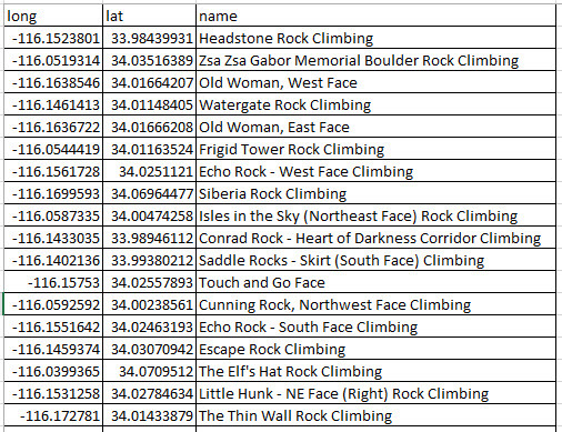 |


|
+1 This would be a cool feature. I use a Garmin handheld, and I also like to make custom printed topo maps using Caltopo. In both cases, I have to copy and paste coordinates for individual areas one at a time. The ability to batch them with GPX would be fanbtastic! |
|
|
Andrew Krajnik wrote: +1 This would be a cool feature. I use a Garmin handheld, and I also like to make custom printed topo maps using Caltopo. In both cases, I have to copy and paste coordinates for individual areas one at a time. The ability to batch them with GPX would be fanbtastic! +2 though I've also noticed depending on the area the GPS might get you to the very general area ( or maybe just a parking lot) and you then default to your own level of land nav skill. |
|
|
Jim Urbec wrote: Yeah, that's a fair point. Not all areas have an exact GPS location in the database. It often defaults to the location of the next-higher area in the hierarchy. |
|
|
Thanks for the comments! |
|
|
Doesn't everyone have a key? When I go to that link, I see my private key listed on the right, along with a warning about how to use it, and what type of activity might result in its deactivation... 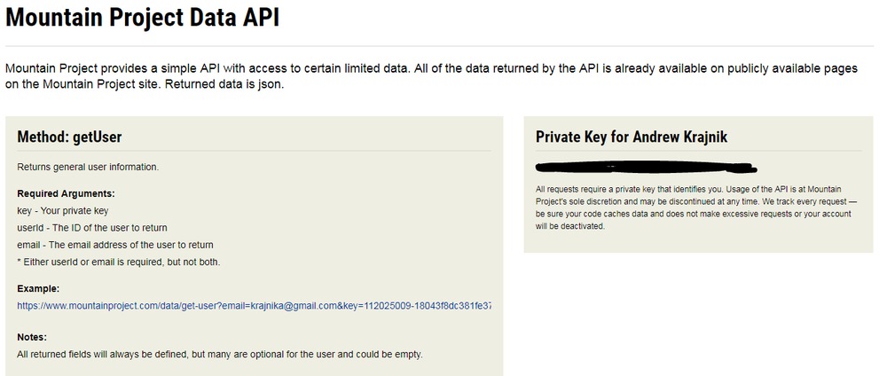 |
|
|
Success! 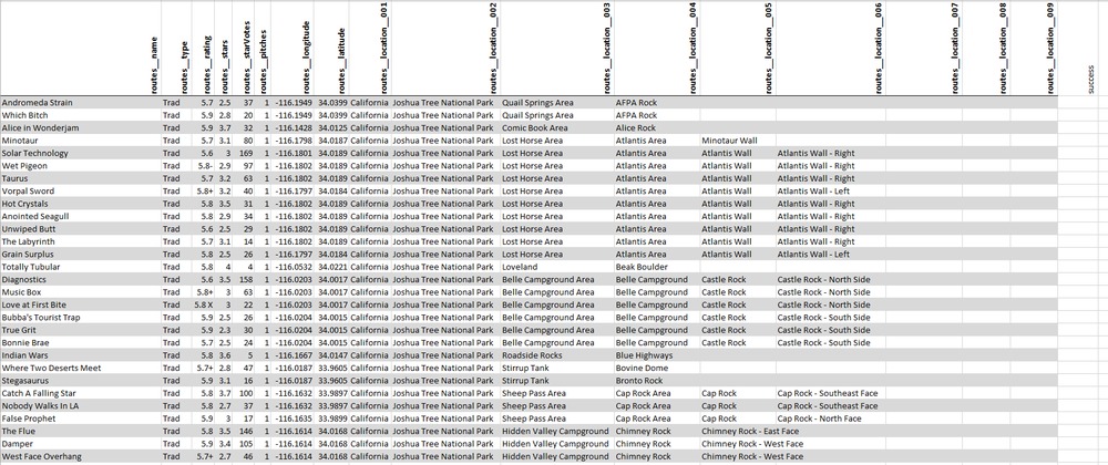 |
|
|
you should redact your key :) |
|
|
khoa wrote: you should redact your key :) woah good call! thanks for that, removed it |
|
|
why do some of those star values seem to be off? |
|
|
tom donnelly wrote: why do some of those star values seem to be off? When translated to numbers in the API, the value of 1 means "Bomb", the value of 2 means "1 star", the value of 3 means "2 stars" etc. A value of 0 means we have no star submissions for that route. |
|
|
I don't know much about coding, but I have a feeling this is similar to what I would like to accomplish. Is there any way to take the CSV file of my to-do list and use that to get a GPX file of the location of all of the climbs within my to-do list? Or at least the wall location? |
|
|
Leo Klotz wrote: I don't know much about coding, but I have a feeling this is similar to what I would like to accomplish. Is there any way to take the CSV file of my to-do list and use that to get a GPX file of the location of all of the climbs within my to-do list? Or at least the wall location? You can export a csv of your to-do list, but it doesn't include the lat/lon coordinates for the climbs in the list. The tick-list csv export does include lat/lon, so I imagine it would be a pretty easy feature to add. |
|
|
How do you find your own private key? |
|
|
Justin Lofthouse wrote: It appears to no longer exist. :( https://www.mountainproject.com/data |
|
|
tom donnelly wrote: why do some of those star values seem to be off? it's actually because it forgot to take into account the equation numstars = FFA stars minus 2. |


