|
|
Jim Bauer
·
Mar 10, 2019
·
Unknown Hometown
· Joined Apr 2014
· Points: 0
Looking for a friend to do the East Ridge of Quandary with this Tuesday 3/12. The snowpack should have settled down a bit by then and the East Ridge is uniformly out of avalanche terrain if you stick to the route anyway.
This will be a long slow distance training segment for me so I'll be going pretty slowly. I'm in Aurora and hope to be at the trailhead around 830 or 9 but I'm flexible timewise. Happy to drive if you're between here and there!
|
|
|
slim
 ·
Mar 11, 2019
·
Unknown Hometown
· Joined Dec 2004
· Points: 1,103
·
Mar 11, 2019
·
Unknown Hometown
· Joined Dec 2004
· Points: 1,103
hmmm, are you sure the route is "uniformly out of avalanche terrain"? i would say low avalanche, but not no avalanche.
|
|
|
Shay Subramanian
·
Mar 11, 2019
·
Denver, CO
· Joined Apr 2017
· Points: 0
There is one avy slope when you break treeline and gain the ridge, if you go by the summer trail. I remember thinking gaining the ridge via the winter route could slide too though, but maybe we went the wrong way.
|
|
|
Long Ranger
·
Mar 11, 2019
·
Boulder, CO
· Joined Jan 2014
· Points: 669
The amount of avalanches in just that range last week was somewhat historical. That would weigh hard on my decision to go.
|
|
|
Jeremy Bauman
·
Mar 11, 2019
·
Lakewood, CO
· Joined Feb 2009
· Points: 1,047
I have a friend who was caught in a slide on the East Face.
|
|
|
Jim Bauer
·
Mar 11, 2019
·
Unknown Hometown
· Joined Apr 2014
· Points: 0
This is what I'm looking at to determine which slopes are > 30 degrees - where am I going wrong?
www.backcountrymap.com/index.html?zoom=14&lat=39.40206700323714&lng=-106.09251026535473&maxSlope=50&minSlope=30&minDir=0&maxDir=180&minAlt=3000&maxAlt=16000&showCliffs=1
|
|
|
Long Ranger
·
Mar 11, 2019
·
Boulder, CO
· Joined Jan 2014
· Points: 669
Here's someone asking about Quandary for Sunday (yesterday)Jim Bauer wrote: This is what I'm looking at to determine which slopes are > 30 degrees - where am I going wrong?
www.backcountrymap.com/index.html?zoom=14&lat=39.40206700323714&lng=-106.09251026535473&maxSlope=50&minSlope=30&minDir=0&maxDir=180&minAlt=3000&maxAlt=16000&showCliffs=1 Really, nothing except the data is not perfect and can also be presented in a different manner depending on the tools. Things can slide at < 30 degrees as well. It's a very auspicious season for avalanches and maybe not the time to go out without being fully prepared. The avy report being at, "Considerable" is still not the greatest. Again, Quandary has a rep. of being easy, but Winter is another game for sure, and this season is been particularly crazy in terms of slides. Inbounds slides are happening (and happening near Quandary on the same aspects as the east ridge), people are getting killed by roof avalanches. They're closing whole highways because of slides, or slide threats. These are big blinking warning signs. Hate for anyone to run into an issue out there, merely for a snowshoe. Lots of good hiking near Boulder! Bring your microspikes!
|
|
|
Rodney P
·
Mar 11, 2019
·
Ouray,CO
· Joined Oct 2011
· Points: 335
Jim Bauer wrote: This is what I'm looking at to determine which slopes are > 30 degrees - where am I going wrong? Jim. this is part of a CAIC report on a fatality from earlier this winter that you may find helpful Assessing and Managing Slope Angle
In discussions after the accident, the group described trying to avoid avalanche terrain. One of the ways they were doing this was by traveling on slopes with an angle less than 30 degrees. Looking at slope steepness was part of their trip planning process and they used common digital tools to look at shaded slope angle layers draped over terrain models or topographic maps. With the help of these tools, they avoided avalanche terrain for most of the day. They also identified the narrow terrain feature where they could keep their slope angle at or below 29 degrees as they worked through much steeper terrain. Their GPS tracks shows that they were either on or very close to their planned route.
We measured slope angles during our visit to the accident site. Measured angles ranged from 32 to 34 degrees on the slope the group was descending when the avalanche released. This is only a few degrees steeper than the shading tools show, but in this case it may have been a very important difference. The group did not attempt to measure the slope angle before their descent. If they had, it is possible that they would have found this discrepancy. On some days and with some avalanche problems, the difference between 29 degrees and 32 degrees might not be significant. However, it can be significant when dealing with a Persistent Slab avalanche problem, especially when a remote trigger is possible.
The difference between a representation of the terrain and the actual terrain is a very important issue for everyone using these tools for route planning. The same issues hold for everything from paper maps to the most sophisticated digital tools. These are very useful tools, but they have limitations and they are most useful when coupled with observations of the physical terrain. In a specific example, the popular mapping software CalTopo derives the slope angle coverage from the USGS National Elevation Dataset (NED). The cells displayed by the software are nominally 10 meters across, though in some locations the underlying source data may be much coarser (Jacobs 2019). The NED could have errors of up to 100 feet in elevation (Scott 2009). Haneberg (2006) found that slope angles for a single cell within a 10 m grid often had a degree or two of error, with typical errors of plus or minus 4 degrees. Most of these tools use the elevation from multiple surrounding grid cells (often 8) to calculate the slope angle (ERSI, retrieved 2019). Thus, elevation errors in one grid cell can affect surrounding cells. With 10 meter cells and a 31-degree slope, a single cell with an elevation 100 feet too high gives a slope angle of 57 degrees, while a single cell 100 feet too low produces a slope angle of 24 degrees. McCollister and Birkeland (2008) examined this issue for avalanche applications and remarked that we are “looking at a depiction of reality. We tend to get excited about the graphics and colors dancing around on the computer screen in front of us and lose track of how that really reflects what is found on the ground.”
|
|
|
aikibujin
·
Mar 11, 2019
·
Castle Rock, CO
· Joined Oct 2014
· Points: 300
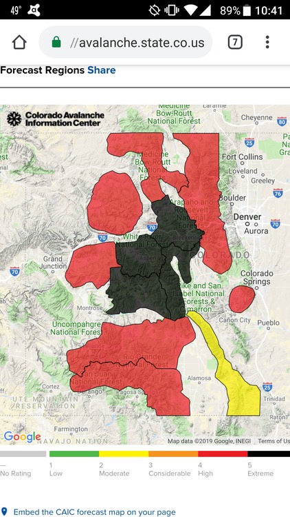
Also worth noting the accident quoted by Rodney happened during an instructor led AIARE level 2 course (for people who already had AIARE level 1 course), on a day where the avalanche danger was rated Moderate (yellow) at all elevations. Even people with experience and education can still make wrong assessment from time to time. Since that accident, the avalanche danger has gone up to unusually high levels just last week, it's only down to Considerable in the last two days. It is in no way settled down by now.
Attached is a screenshot from last Thursday. I have never seen so many red and black zones at the same time in the last few years in CO.
|
|
|
Jim Bauer
·
Mar 11, 2019
·
Unknown Hometown
· Joined Apr 2014
· Points: 0
I really appreciate all the input folks. Putting the climb on hold until things look a bit better.
I did Bear Peak yesterday, I need to put my boots in some real snow though! Planning on a skin up Winter Park tomorrow to get at least a little higher. Hopefully things will improve by the weekend.
|
|
|
slim
·
Mar 11, 2019
·
Unknown Hometown
· Joined Dec 2004
· Points: 1,103
Jim Bauer wrote: This is what I'm looking at to determine which slopes are > 30 degrees - where am I going wrong?
www.backcountrymap.com/index.html?zoom=14&lat=39.40206700323714&lng=-106.09251026535473&maxSlope=50&minSlope=30&minDir=0&maxDir=180&minAlt=3000&maxAlt=16000&showCliffs=1 long ranger already touched on this but 30 degrees isn't a silver bullet number, and you are basing your assessment of the slope angle on a map of sorts, which may or may not be accurate.
|

 Continue with onX Maps
 Sign in with Facebook