
 Continue with onX Maps
 Sign in with Facebook


Does anyone know anything about this cliff band?


|
|
I am curious about this fantastic looking band of rock (edit- it could be a 100 yard cutie and be a choss pile for all I know) on Hwy 77 in between Winkleman and Globe. I am normally cautious about putting off the beaten path rock on the internet but this beautiful piece of geology sits prominently displayed to every motorist that drives by so I don't feel like I am revealing anyone's secret spot. I am interested in the general history and not so much individual route details. And don't worry, I highly doubt I will be putting any routes up out there due to chronic AOASS (All Old And Shit Syndrome). 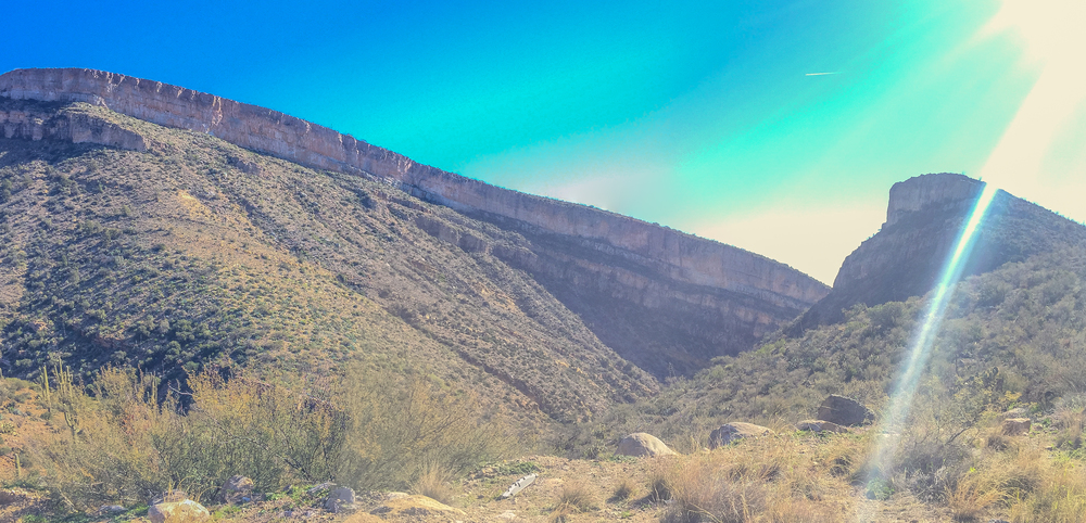 |

|
That's pretty close to the Homestead, I think. There has probably been some exploration around there given the development of the Homestead but I don't know of any actual route development or who owns the land. |
|
|
You are correct sir. I thought I had looked at the MP Google Earth thinger to determine if there were some surrounding crags but I must have missed the Homestead somehow. Looks like a neat place and warrants a future visit. It appears to be some great limestone which would lead me to believe that this wall is solid as well. The approach is steep so I am sure many have stopped like I did and then moved onto easier access. |
|
|
Well I can't tell very well from the photo but to me it looks like choss. Could just be the glare, though. |
|
|
I could most definitely be wrong but 20 years of exploring new rock tells me that it is solid. I am fairly certain it's on public land (99% certain). Its just over the hill from the Homestead. |
|
|
From a distance, it looks a whole lot like a typical limestone area in Spain. Before I returned to the fold and started climbing again, I would ride my bike past such cliff bands here in Catalunya and idly think, “That looks like a big pile of vertical bird shit. I bet no one climbs that.” Only to find out later that one such local area sported nearly a hundred or so nice sport routes (see Vallirana, Turo de Cal Beco and Les Casetes, for example.) You never know until you check it out. Clarifying property lines/owners, land access, etc would be the first step I would think. |
|
|
Kyran Keisling wrote: I could most definitely be wrong but 20 years of exploring new rock tells me that it is solid. I am fairly certain it's on public land (99% certain). Its just over the hill from the Homestead. Well I certainly hope I'm wrong! Around here, the orangeish, pink, or whitish bands of limestone tend to be pretty chossy and also get greasy much faster. The gray and sometimes brownish rock tends to be much better quality and more resistant to the slime factor. |
|
|
eli poss wrote: Got it! Makes sense for sure. Although I am usually pretty accurate from a distance, I have been suckered into the hike of shame many times in my "illustrious" career. |
|
|
Kyran Keisling wrote: It's not the "hike of shame" its a fun adventure ;) Chossaneering can be fun every once in a while |
|
|
It's called ElCap canyon just off the 77 right before the turn to the Stead. It is on private property. The Developers were ask to leave and pointed to the Homestead. |
|
|
Well I'll be a monkey's uncle! I would have bet my left nut that that was public land. Well, that explains it then. Thanks for the nugget David. |
|
|
eli poss wrote: Being from N. AZ and Navajo Sandstone/Kaibab Limestone, having "fun adventures" is the norm and not a once in a while thing. But yeah, I love it in a masochistic kind of way. The best part about it is that it tends to repel yer city gym climber dub step type folk and keep the lines short at the classics. |
|
|
Kyran Keisling wrote: Nice, you are a bolder soul than I. I mean, what I climb on regularly is considered choss by some, but it's where I learned to climb so baseline for me. It is the san juans, after all. But probably about once a year I get the urge to get on something really chossy where I'm snapping like every other hold and have to test holds like 5 times before I can commit to them. Lots of fun when I'm in the mood for it but I value my life too much to do it very often. Good ole type 2 fun. |
|
|
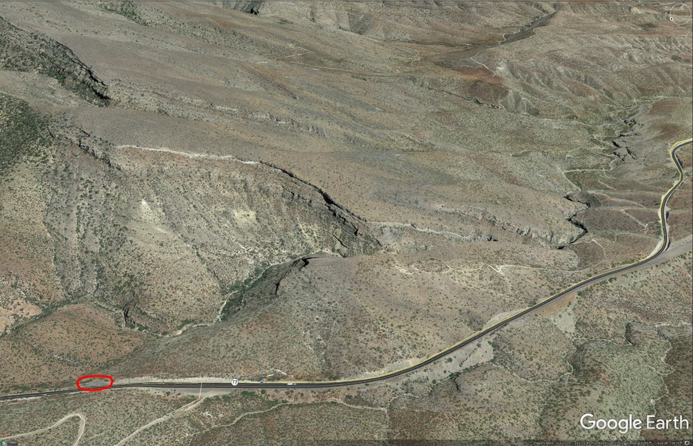
David Stephens wrote: It's called ElCap canyon just off the 77 right before the turn to the Stead. It is on private property. The Developers were ask to leave and pointed to the Homestead. For the most part the "private property" info is correct in that particular area but there is a bit of State Trust and BLM there too. Not bad rock as I recall from my visits :) http://gis.azland.gov/webapps/parcel/?loc=-110.8056,33.1800,15&layers=0,1,0If this link doesn't take you right to the spot then use the Arizona State Land website mapping tools; they are pretty spot on. |
|
|
Really nice Fred! What a great recourse, I appreciate the link. And wow that BLM land goes right through the middle of the cliff band. Whoda thunk? |
|
|
Fred AmRhein wrote: Thanks, Fred Good info.
|
|
|
David Stephens wrote: We should all pitch in and buy it. What a beautiful piece of earth! |

|
As a few have mentioned, this is the el cap canyon, more specifically the north end. The north end is where the private land is and where the easier approach is. The approach from the south is sketchy at best but could probably be made into a usable trail with a lot of work. The more impressive face is the walls on the west side of the canyon (the right feature in the picture). Unfortunately the rock quality seemed to be lacking but might clean up. My biggest concern is the over abundance of bees! It would take A LOT of work to make it a viable crag but definitely doable. |
|
|
David Stephens wrote: One of the best typos recently! |
|
|
Alex "Tojo" Kray wrote: My biggest concern is the over abundance of bees! It would take A LOT of work to make it a viable crag but definitely doable. Duly noted on the bees! I'll make sure to take my EpiPen :-). There will be not A LOT of work coming from this camper. I plan on hiking around there next time I'm in the area and maybe pluck a cherry line if it exists but some other masochist will have to be in charge of the A LOT of work part, I have plenty of that going on up here in the land of sand. |
|
|
 |


