
 Continue with onX Maps
 Sign in with Facebook


Isolation Canyon access heads-up


|
The landowner near the "former" parking for Isolation Canyon has been busy as of late. Friends and I ventured down the usual approach via Bradshaw dr on Sunday to find several Private Property No Trespassing signs along the road. Just beyond where the road forks left is a row of boulders and berms blocking access to the dirt road that leads to the Forest Service land gate.  Also the dirt road just south of the turn-off to Pine Trailhead is blocked with boulders. We parked here and walked around the perimeter of the barbed wire fence to get to the Forest Service gate, which is now locked.   From talking to others that day, easiest new approach is the turn-off ~0.7 miles south of Bradshaw Dr with a short drive to get back north to where the Old County road meets up with the AZ Trail. Easier to depict on a map: 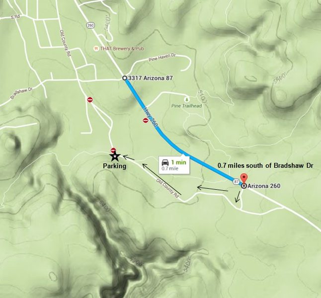 |
|
|
Thanks for the heads up! |
|
|
That sucks. Great info. I'll check into what happened. Taking the road you described is near the original trail into the climbs. We could take a look at that as an alternative. |
|
|
I've contacted Pine Fire Dept. I'm not sure it's a good idea to block access to the gate. |
|
|
Bump |
|
|
Thanks for looking into it, Manny. Not sure how anyone thinks chaining a forest service gate is a good idea |
|
|
Thanks for checking on things, Manny. |
|
|
Skip the FD and ask the USFS what the deal is. |
|
|
Thank you for posting the info Ben. Laurel Arndt said she is pursuing the TNF access question. She also said the property was purchased in 2007 and he could tie up access forever. |
|
|
I was curious, so I pulled up the parcel map for the area via Gila Co's assessors site (all public info, not trying to be a creep)  Based on the 2015 assessor records, there are really four independent land managers in the vicinity of the former access road/trail (parcels 8E, 8F, 8G, and 10A). Searching for "301-34" from Gila Co. Assessor's site yields the owners of the above map. |


