
 Continue with onX Maps
 Sign in with Facebook


Never, ever trust any kind of weather summary/convenient widgit


|
|
Weather summaries - simple, fast, convenient .... and usually dead wrong. Today I came upon a particularly terrible weather error. I googled, “Lake Louise, Canada weather”. Here is what came up: 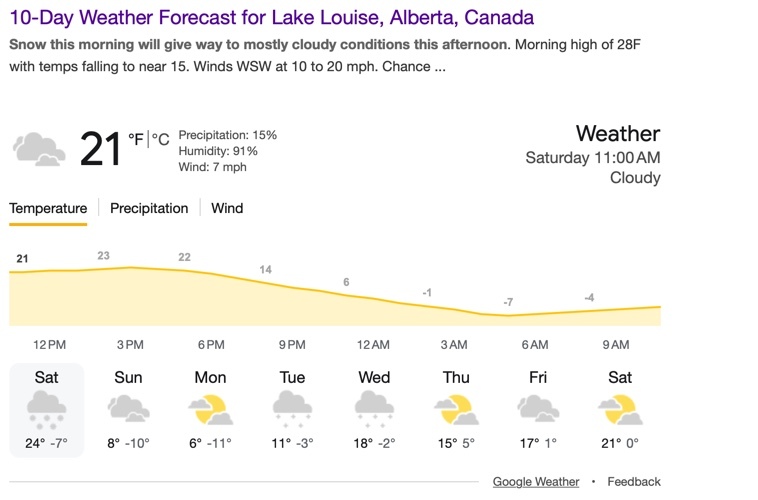 So, coldest temp present was -11. But someone else told me forecast was much colder, -17 and below. Odd. Then I clicked on the very first link to weather channel: 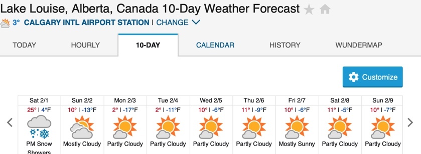
The error (google-weather channel) in the low temp is, starting from Sat: +3, +3, +6, +8, +4, +14, +7, +7 degrees F!!!! ***AN ERROR OF 14 degrees????? Just unbelievable. (every weather service I checked directly on their web pages had almost precisely the same results as weather channel, the only outlier was the google summary.) I don’t know whether google came up with last week's weather, Lake Louise USA weather, or what. But I find that convenient, simple summaries like the default app my phone, or the search summary values, are often terrible. The weather app on my iphone: sa,su,mo, tue, We,Thu,Fri Lows: +4, -8, -13, -17, -16, -10,-9 WCha:+4,-13,-17, -11, -6, -9, -6 Error: 0, +5, +4, -6, -10, -1, -3 degrees F I also note that going to the web page of a weather service is often a tremendously HORRIBLE experience - weather underground had so many ads that it was practically useless. ***However, at least their temps. are correct!*** Generally speaking I find weather.gov to be the most dependable in CA, though of course, sometimes wrong. For outside of the US I haven’t really done comparisons generally. GOOD LUCK. IGNORE nice, convenient weather summaries! -TPC |

|
They probably just used an AI to generate the statistically most likely weather for that time of year. |

|
Anyone who's using Google for consequential weather forecasts deserves frostbite. Also if you use Windy you can compare several models. |
|
|
I am under the impression that only NOAA collects data for the US, so that is the basis of all (?) weather forecasting in the US. Though that claim might be a little imprecise What I would like to know is whether local meteorologists construct their own forecasts using their own tweaked models. I suspect so. I have always used NWS forecast with generally good results. Is there reason to believe a local forecast would be more reliable? |
|
|
Weather forecasts are a lot like climbing grades except that they are more accurate indoors |
|
|
I once drove up to Shasta for an attempt based on a forecast of 5 mph winds. When I got there it was blowing 80 to 100 at the top of red banks. |
|
|
Weather predictions on the widgets or basic weather sites arent ever reliable. When I plan for big outings, I use a number of different sites, radars and models and thats still never 100% but it gets me close enough. And always have a backup plan in the event the weather turns against the predictions. Its always wise to have some small backup plan. Mountain/Valley weather is very volatile and can change very quickly. |
|
|
The NOAA forecasts are "local" to the granularity of forecast office regions. Whether they dial the forecast in better than the TV channel weather person, would be a good project for someone in a statistics class. I'm a big fan of the NOAA area forecast discussion. It tells me what's going on behind the temp & wind speed numbers. It provides an idea of the forecast certainty and how else things might play out. I pay attention to neighboring area forecasts too. In New England, it helps to piece together the Albany, Boston, and Portland discussions. In Tuolumne meadows, the Reno and Bakersfield discussions... In mountains in remote parts of the world, the generic weather summary is just noise. There just isn't enough data to make any kind of pinpoint forecast. Even Environment Canada has only a macro-scale understanding of the weather in the mountains of the Northwest Territories. |
|
|
The WeatherUnderground 10-Day forecast *graphs* are my go-to. (The graphs. Why anybody would choose to look at a 2 number forecast to characterize a day is beyond me) Take a screenshot of the 10-Day prior to the trip. Take another screenshot prior to leaving cell coverage. A ~3.5ºF/1kft lapse rate is usually pretty decent for accounting for temperatures at elevations higher than the forecast location. For places like Mt Washington, the MWOBS Higher Summits Forecast in conjunction with the wunderground lower elevation forecasts for wind timing - this helps to narrow down the timing of weather events. I seem to recall MWOBS giving more detail for the hour of the day for arrival of fronts, but now it seems to be more generic, and not timing down to the hour - but, memory is a funny thing. At any rate MWOBS will put a much sharper point on temperatures than the Std Day lapse rate. I suppose I could pull up my old USAF charts for integrated hot/cold day lapse rates, but -3.5 seems good enough. And if needed, or just curious, I can always just message my uncle. Grad degrees focusing on meteorology, or something like that. |
|
|
Charlie Kissick wrote: Long ago we fortunately camped down low near Horse Camp. When we got to Lake Helen the wierd catabatic wind was blowing about 70mph, and the people in tents there had to stay in their tents to hold them in place. We hung out a while slightly lower behind a bank. Soon the wind let up. I'm not sure if any general forecast can predict such strange localized downslope wind. |
|
|
The NOAA graph is my go to but really only up to about 4-5 days  |
|
|
Like others have said, I like NOAA, but also look at the first couple links from a Google search to compare. The best estimate is always somewhere in between right? The ads on weather sites are pretty junky I can definitely sympathize. |
|
|
If you're not using the windy app(red) at this point you're an idiot, literally your whole day and your safety is hugely influenced by the weather, take this shit seriously. |
|
|
Weather.gov / NOAA gang here.... its is how the NFL forecasts....worked a couple superbowls and weather was directly tied to if we could perform, so got to look behind the curtain with their meteorology team a wee bit. Nothing but NOAA data was used. God knows it could be different year to year, but in my two exposures NOAA was it and I have had great reliability/trust using it in my personal exploits. |
|
|
I like apps like meteoblue that give you a multi model view. This gives you a feeling for how uncertain a forecast is for a given period of time in the future. 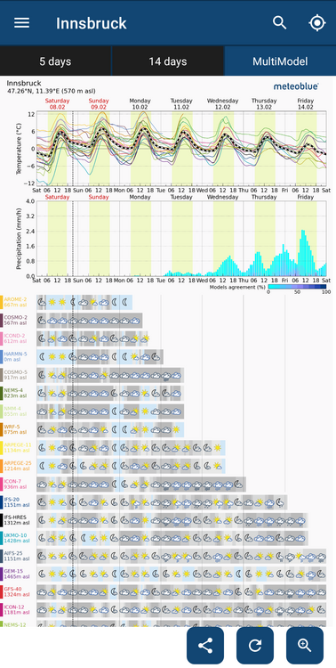 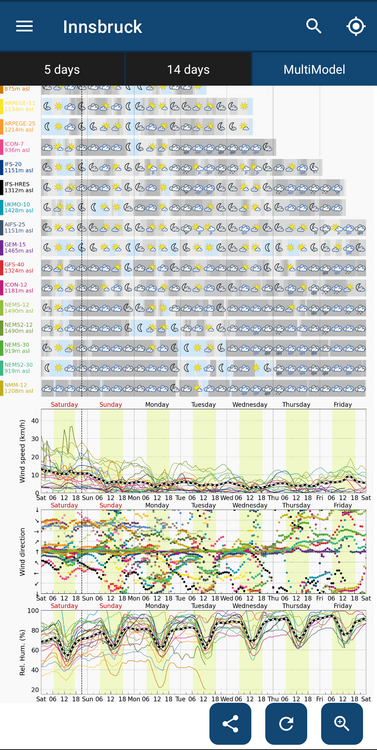 |
|
|
I will never forgive Apple for removing and killing the most accurate, well laid out, free, awesome weather app that was dark sky. |
|
|
Another MeteoBlue fan here. I use NOAA data as well, but Meteo Blue seems to use some additional models and has been really really accurate for me. |
|
|
for the most part our modern weather reports are amazing. folks that like to bitch about them have too much time on their hands and don't remember the days when you got your weather report from a day old newspaper. |
|
|
At risk of getting the thread shut down by introducing politics... I wonder how long NOAA will even remain fully functional. Does anyone have a plan for when NOAA's staff and budget get minced? It's my understanding that the majority of the publicly available models rely nearly exclusively on federally funded data collection. Are there any orgs that are working to stand up comparable data collection? The models are one thing, the data used to run them is another. |
|
|
Since the government controls the weather, why go anywhere else? Weather.gov FTW |
|
|
Andy Shoemaker wrote: My plan- cry big salty tears and inevitably get hit by a lightning storm while retreating from a successful summit. |


