
 Continue with onX Maps
 Sign in with Facebook


The Penokean Wall Rock Climbing
Routes in The Penokean Wall

|
Aerial TR 5.11 6c+ 23 VIII- 23 E4 5c |

|
Can't Trust the Weatherman TR 5.10b/c 6b 20 VII 20 E2 5b |
|
|
Desperation TR 5.11 6c+ 23 VIII- 23 E4 5c |
|
|
G-Spot TR 5.10a 6a 18 VI+ 18 E1 5a |
|
|
Golden Days TR 5.10b 6a+ 19 VII- 19 E2 5b V1+ 5 |
|
|
GRÜV TR 5.9+ 5c 17 VI 17 E1 5a |
|
|
Happiness Lake S,TR 5.8+ 5b 16 VI- 15 HVS 4c |
|
|
Hernia TR 5.9+ 5c 17 VI 17 E1 5a |
|
|
High Life TR 5.11 6c+ 23 VIII- 23 E4 5c V2 5+ |
|
|
Jelly Beans for Power V1-2 5 |
|
|
LEAF!! TR 5.10a 6a 18 VI+ 18 E1 5a |
|
|
Lego Spaceship TR 5.6 4c 14 V 12 S 4b |
|
|
Papa Smurf TR 5.9- 5c 17 VI 16 HVS 4c PG13 |
|
|
Samson the Otter TR 5.10a 6a 18 VI+ 18 E1 5a |
|
|
Whitney V1 5 |
|
|
Writers Block TR 5.9 5c 17 VI 17 HVS 5a |
| Elevation: | 1,597 ft | 487 m |
| GPS: |
45.4744, -91.50176 Google Map · Climbing Area Map |
|
| Page Views: | 10,770 total · 130/month | |
| Shared By: | Michael Klonowski on Mar 15, 2019 · Updates | |
| Admins: | Doug Hemken, James Schroeder, chris tregge, Ben Strobel, Kyle Harding |
Description

A secluded sandstone crag in a small, wooded Northern Wisconsin valley in the area known as the "Blue Hills." The main section of the crag has a length of about 100 feet and an average height of about 25 feet. Up and down the valley where it lies, there are numerous opportunities for bouldering. The Blue Hills are the remains of an ancient mountain range, called the Penokean Mountains that ran from Niagra Falls through Northern Wisconsin. A couple of sections are currently being cleaned. The rock around LEAF!! (5.10a) is generally clean and great for climbing. Golden Days (5.10b), while a shorter route, is an excellent choice to test out your reach on great holds. Bolts were just added to Happiness Lake (5.8+) and hopefully more will be added soon. A perfect spring or fall training ground for those in Northern Wisconsin, as summer climbing here is almost impossible with the amount of mosquitoes. If you plan on climbing here regularly, it may be helpful to familiarize yourself with the locations of the other geological landmarks in the area i.e. the Felsenmeer and Devil's Kettle. It is not uncommon for a group of lost hikers to stumble upon the Penokean.
*Note: route grades may be in need of adjustment
Getting There
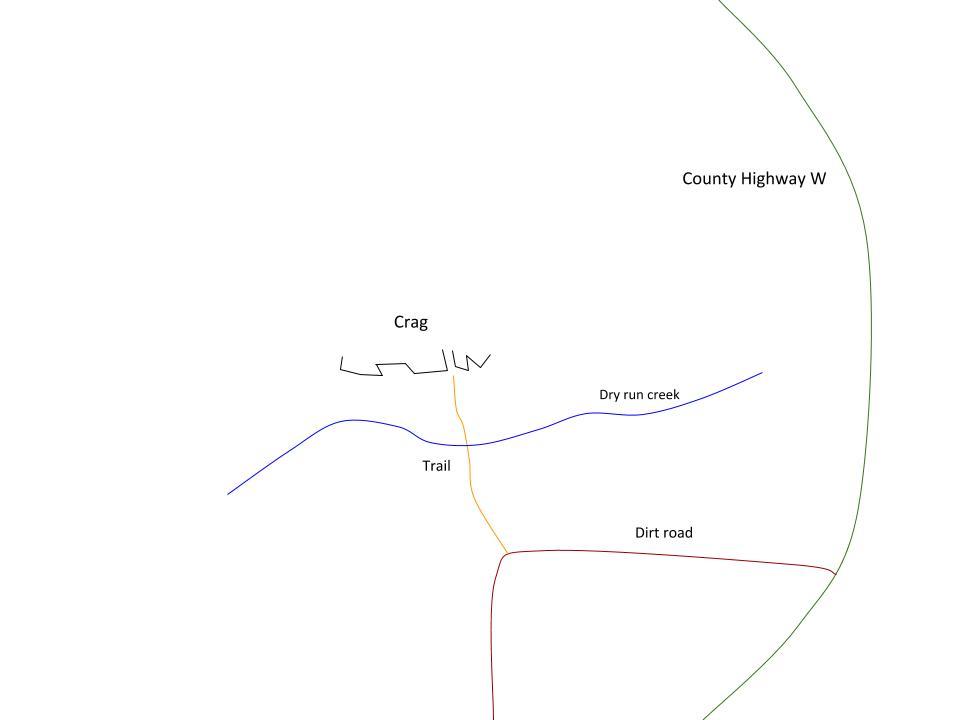
About a 20 minute drive East from Rice Lake in Barron County, the Wall lives in the area known as the "Blue Hills." From Rice Lake, take Highway O East out of town and after about 25 min, turn right onto County Hwy W (this will be right before O meets up with Hwy F). County Hwy W in the Blue Hills curves around these cliffs. Off the south side of the curve on W there is a dirt road. Drive down to the turn in this road and park on the side. On the north side of this dirt road there is an opening to a path through the woods down into a small valley. Once in the valley keep walking to the other side and you will see the cliffs. Depending on how well you navigate the rocky valley floor, the walk should take less than 5 minutes. It is recommended to use the GPS coordinates (45.474117,-91.501050) with Google Maps to help find this location. Reference the topo maps and photos of the trail for easier navigation.The walk out follows a path until you get down into the valley, then it is somewhat scrambley, as there are a lot of sharp boulders and fallen trees obstructing the path, so make sure you have some decent shoes.If you are going in the summer months, be sure to bring a lot of water and bug spray.
Classic Climbing Routes at The Penokean Wall
Sun & Shade
Weather Averages
|
High
|
Low
|
|
Precip
|
Days w Precip
|
| J | F | M | A | M | J | J | A | S | O | N | D |
| J | F | M | A | M | J | J | A | S | O | N | D |
Photos


All Photos Within The Penokean Wall
Most Popular · Newest · RandomMore About The Penokean Wall
Printer-FriendlyWhat's New
Guidebooks (2)


13 Comments