
 Continue with onX Maps
 Sign in with Facebook


The Pearly Gates Rock Climbing
Routes in The Pearly Gates


|
Archangel S 5.11a 6c 22 VII+ 22 E3 5c |
|
|
Good Book, The S 5.10a 6a 18 VI+ 18 E1 5a |
|
|
Pillar of Salt S 5.8 5b 16 VI- 15 HVS 4c |
|
|
Right Hand Of God S 5.11+ 7a 24 VIII 24 E4 6a |
|
|
Saint Peter S 5.11b 6c 23 VIII- 23 E3 5c |
| Elevation: | 7,233 ft | 2,205 m |
| GPS: |
39.74492, -105.40291 Google Map · Climbing Area Map |
|
| Page Views: | 5,965 total · 61/month | |
| Shared By: | Furthermore on Feb 13, 2018 · Updates | |
| Admins: | Leo Paik, John McNamee, Frances Fierst, Monty, Monomaniac, Tyler KC |
 Access Issue: Seasonal Raptor Closures
Details
Access Issue: Seasonal Raptor Closures
Details
Raptor Closures Effective February 1-July 31
Visit: jeffco.us/open-space/news/2…
Tunnel 1 closure
For more details visit: jeffco.us/open-space/alerts…

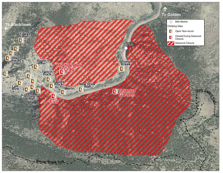
The two areas Jefferson County Open Space intends to close in Clear Creek Canyon, shown on the attached maps, encompass the active eagle nests. If the Clear Creek eagles continue to nest in the active nests, these areas will remain closed from February 1 through July 31. If the eagles choose different nesting sites, the closures will be adjusted accordingly to protect those eagles during their breeding season.
Currently, rock climbing areas that fall inside of the seasonal raptor closures include:
Blonde Formation
Bumbling Stock
Evil Area
Ghost Crag
Highlander
Skinny Legs
Stumbling Block
Tetanus Garden
Fault Caves
Description

Located high on the cliff above the Graveyard and Death Valley, The Pearly Gates currently offers two powerful routes. Due to their overhanging nature, it's recommended to warm up on a few climbs at the Graveyard or Death Valley before making the short hike up the hill to the crag.
The Pearly Gates absorb sunlight longer than the Graveyard or Death Valley as the crag is south-facing and high above the river, making it an ideal option for cold winter days. Despite a little longer approach, this crag offers an uncrowded, quiet and beautiful setting.
L->R:
A. The Good Book, 9+/10-, 1p, 55', bolts
B. Pillar of Salt, 8, 1p, 60', bolts
C. Right Hand Of God, 11+, 1p, 70', bolts.
D. Archangel, 11-, 1p, 65', bolts.
E. Saint Peter, 11, 1p, 65', bolts.
Getting There
From the Catslab parking area, hike east (downriver) on the Peaks to Plains Trail. Follow the bike path/trail for about 0.5 mile as the path makes a large U turn and starts heading back west. Before heading back west on the bike path, locate and follow the trail to the base of Death Valley.
At the base of the cliff for Death Valley, instead of hiking left to the routes at Death Valley, hike right and try to locate an old trail (old approach for Morning Glory?) on the south end of the cliff near some talus. Try to follow this old trail as it contours above Death Valley and back west to the obvious overhung cliff (Pearly Gates) high on the hill.
Classic Climbing Routes at The Pearly Gates
Weather Averages
|
High
|
Low
|
|
Precip
|
Days w Precip
|
| J | F | M | A | M | J | J | A | S | O | N | D |
| J | F | M | A | M | J | J | A | S | O | N | D |


All Photos Within The Pearly Gates
Most Popular · Newest · RandomMore About The Pearly Gates
Printer-FriendlyWhat's New


8 Comments