The Graveyard Rock Climbing
| Elevation: | 7,060 ft | 2,152 m |
| GPS: |
39.74438, -105.40288 Google Map · Climbing Area Map |
|
| Page Views: | 116,317 total · 1,295/month | |
| Shared By: | Furthermore on Jan 15, 2018 · Updates | |
| Admins: | Leo Paik, John McNamee, Frances Fierst, Monty, Monomaniac, Tyler KC |
 Access Issue: Seasonal Raptor Closures
Details
Raptor Closures Effective February 1-July 31
Visit: jeffco.us/open-space/news/2…
Tunnel 1 closure
For more details visit: jeffco.us/open-space/alerts…
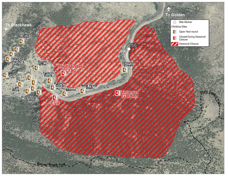
The two areas Jefferson County Open Space intends to close in Clear Creek Canyon, shown on the attached maps, encompass the active eagle nests. If the Clear Creek eagles continue to nest in the active nests, these areas will remain closed from February 1 through July 31. If the eagles choose different nesting sites, the closures will be adjusted accordingly to protect those eagles during their breeding season.
Currently, rock climbing areas that fall inside of the seasonal raptor closures include:
Blonde Formation
Bumbling Stock
Evil Area
Ghost Crag
Highlander
Skinny Legs
Stumbling Block
Tetanus Garden
Fault Caves
Description

L->R:
A. Cruisin' Caskets, 8, 1p, 75', bolts.
B. Six Feet Under, 9+, 1p, 80', bolts.
C. Tomb Raider, 12-, 1p, 50', bolts.
D.The Reaper, 10+, 1p, 75', bolts.
E. Reincarnation, 10, 1p, 75', bolts.
F. Afterlife, 10-, 1p, 75', bolts.
G. Ugoogoly, 10, 1p, 85', bolts.
H. Till Death Do Us Part, 6, 1p, 70', gear.
I1, The Walking Dead, 12, 1p, 40', bolts.
I2. Back From the Dead, 12, 1p, 40', bolts.
J. Low Priest, 9, 1p, 50', bolts.
above J. High Priest, 12, 1p, 75', gear & bolts.
K.City of the Dead, 12-, 1p, 85', bolts.
L. Ernest Stemmingway, 11-, 1p, 80', bolts.
M. Grave Digger, 12, 1p, 65', bolts.
N1. Dia de Los Muertos , 12-, 1p, 60', bolts.
N2. Exhumation, V2+ PG-13, 12'.
N3. Hellbender, 12, 1p, 65', bolts.
O. Spinal Tap, 11+, 1p, 65', bolts.
P. Bone Daddy, 9, 1p, 60', bolts.
Q. The Undertaker, 10-, 2p, 130', bolts.
Getting There

From the Catslab parking area, hike east (downriver) on the Peaks to Plains Trail. Follow the trail for about 0.5 mile as the trail makes a large U turn and starts heading back west. Keep your eyes open for a trail on the right side of the bike path leading up to the base of the crag. Expect a 10-15 minute approach.
New as of 6/25/21: per Daniel Dunn, Stewardship Manager, BCC: in 2021 the BCC, Clear Creek County trail crew, and volunteers built a new approach trail to the cliff. Continue past the old, closed trail for about 30 seconds, and start up where the crag sign is located. This new approach only adds a minute or two to the overall time and is much more sustainable.
Per Zachariah Dzielinski: after the U turn, the original steep trails directly up the side of the mountain have been closed off, take the relatively new and less-steep trail that is further past and on the right side. Potentially marked by a cairn (if it's still up), this trail heads up along the rock face directly to the Dia de los Muertos and Spinal Tap areas.
Classic Climbing Routes at The Graveyard
Sun & Shade

Weather Averages
|
High
|
Low
|
|
Precip
|
Days w Precip
|
| J | F | M | A | M | J | J | A | S | O | N | D |
| J | F | M | A | M | J | J | A | S | O | N | D |
Photos
All Photos Within The Graveyard
Most Popular · Newest · RandomMore About The Graveyard
Printer-FriendlyWhat's New
Guidebooks (16)

 Continue with onX Maps
 Sign in with Facebook


7 Comments