
 Continue with onX Maps
 Sign in with Facebook


Parcher's Bluff Rock Climbing
Routes in Parcher's Bluff

|
Work Avoidance Work T 5.10b 6a+ 19 VII- 19 E2 5b |

|
Kick Aspen S 5.10c 6b 20 VII 20 E2 5b |
|
|
Parcher's Prow T 5.6 4c 14 V 12 S 4b |
|
|
Horatio Hornslinger T 5.10a 6a 18 VI+ 18 E1 5a |
|
|
Boogie with Xeno S 5.11c 6c+ 24 VIII- 24 E4 6a |
|
|
Robert Fonda Memorial Route (RFMR) T 5.10b 6a+ 19 VII- 19 E2 5b |
|
|
Rock On T 5.9 5c 17 VI 17 HVS 5a |
|
|
Little Wiggler TR 5.11a 6c 22 VII+ 22 E3 5c |
|
|
Thirstin' Howl S 5.10c 6b 20 VII 20 E2 5b |
Order Wrong?
Sort Routes
Use onX Backcountry to explore the terrain in 3D, view recent satellite imagery, and more.
Now available in onX Backcountry Mobile apps! For more information see this post.
| Elevation: | 10,264 ft | 3,128 m |
| GPS: |
37.21579, -118.55674 Google Map · Climbing Area Map |
|
| Page Views: | 8,851 total · 88/month | |
| Shared By: | MisterE Wolfe on Feb 6, 2017 | |
| Admins: | Aron Quiter, Euan Cameron, Mike Morley, Adam Stackhouse, Salamanizer Ski, Justin Johnsen, Vicki Schwantes |
Description

Parcher's Bluff is a Southwest facing cliff at 9200'. Nestled among quaking aspen, lupines and wild rose, it is a nice late summer & fall spot - cool in the mornings and often comfortable even in the sun.
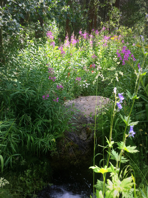
 Flowers along South Fork of Bishop Creek.
The climbing is mixed and sport on granite, sometimes requiring longer slings to "tie-off" xenoliths for protection. The routes are generally shorter - 40-60 feet - but with enjoyable moves on good rock in a verdant setting. The approach is maybe 10 minutes along an old road and established trail, making for a fun, low-commitment outing.
On the mixed routes, the protection may be difficult to see, but wherever there isn't bomber gear, you will find a bolt - and anchors are installed on all routes listed.
There are a few top-rope/lead? old hard-man routes on the left side - sourced here:
http://www.rockclimbing.com/routes/North_America/United_States/California/Bishop_and_Eastern_Sierra/Parcher_s_Topropes/.
Scramble to the top of the formation from the right side and work your way down to set these up. No fixed anchors.
Getting There
From the 395/Line Street junction, continue west on East Line Street, and continue as it turns into Highway 168. From the junction to the South Lake road is 15 miles.
Turn South on South Lake Road, and continue 5.7 miles to Parcher's Resort. Check for traffic and pull a U-turn. Go back downhill about 100 yards to a small gravel turn-out across from the Resort. Park and hike downhill until you see a large fallen log in the creek. Cross the log, and follow the old road North.
Alternately (if you are not comfortable with the log crossing), you can park further up and use the entrance to Parcher's Resort. Follow the road down to an obvious fork. Left will get you to the old road and right will take you to Rainbow Pack Outfitters.
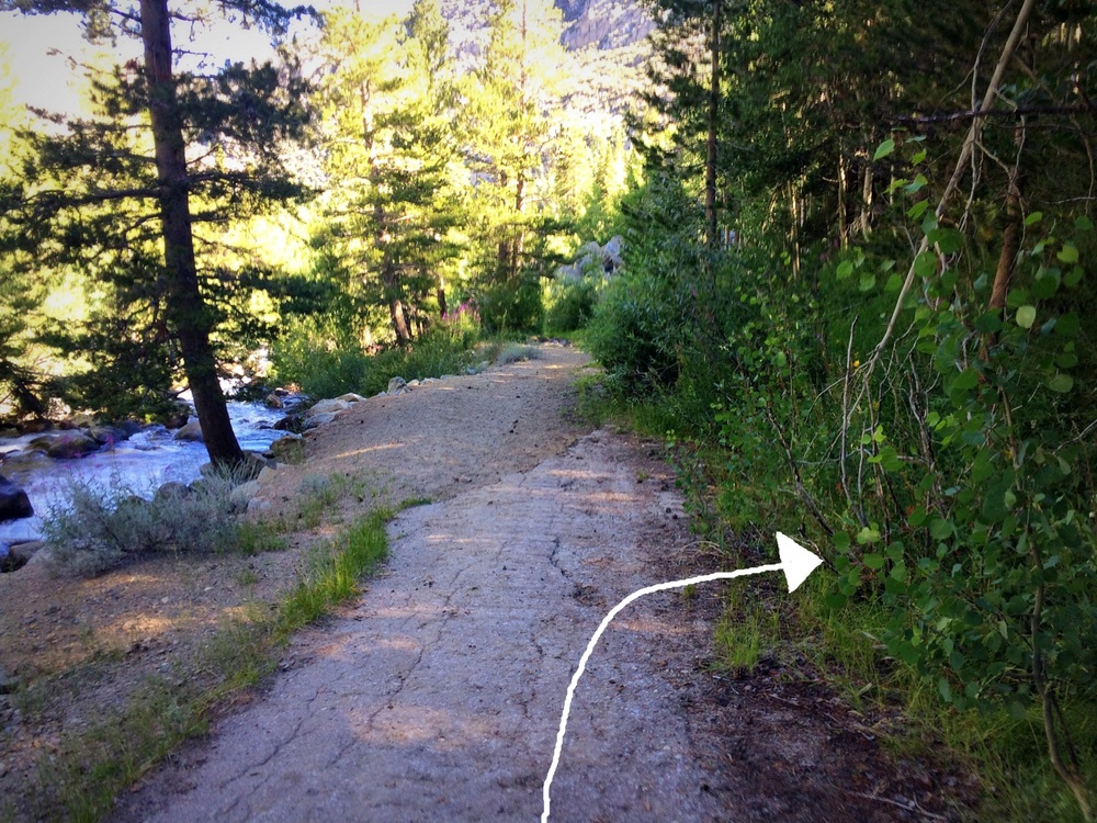
About 400 yards down, just where the pavement ends and turns to dirt, look for a break in the dirt hill-side. Follow a trail up & left to the base of the climbs.
Trail cut-off at the end of the pavement.
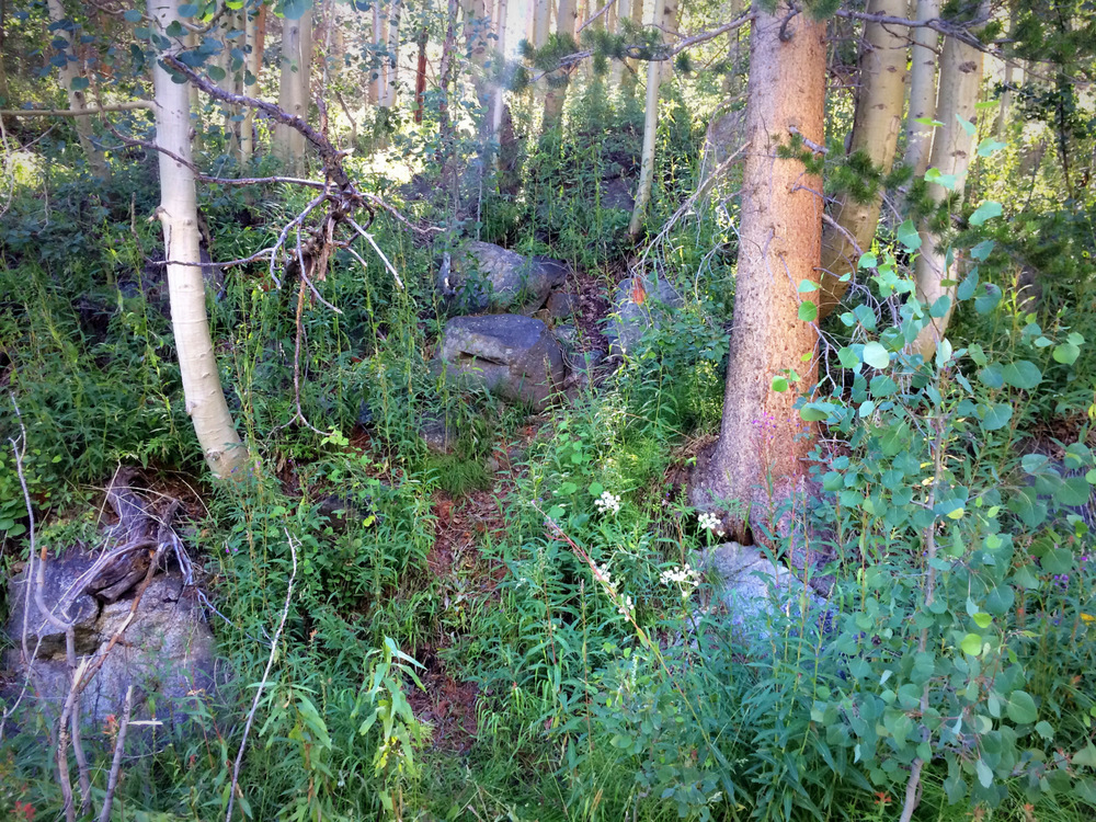
The scramble up to the trail - note stacked boulders.
Turn South on South Lake Road, and continue 5.7 miles to Parcher's Resort. Check for traffic and pull a U-turn. Go back downhill about 100 yards to a small gravel turn-out across from the Resort. Park and hike downhill until you see a large fallen log in the creek. Cross the log, and follow the old road North.
Alternately (if you are not comfortable with the log crossing), you can park further up and use the entrance to Parcher's Resort. Follow the road down to an obvious fork. Left will get you to the old road and right will take you to Rainbow Pack Outfitters.
About 400 yards down, just where the pavement ends and turns to dirt, look for a break in the dirt hill-side. Follow a trail up & left to the base of the climbs.
Classic Climbing Routes at Parcher's Bluff
Mountain Project's determination of the classic, most popular, highest rated climbing routes in this area.
Weather Averages
|
High
|
Low
|
|
Precip
|
Days w Precip
|
Prime Climbing Season
| J | F | M | A | M | J | J | A | S | O | N | D |
| J | F | M | A | M | J | J | A | S | O | N | D |
Photos


All Photos Within Parcher's Bluff
Most Popular · Newest · RandomMore About Parcher's Bluff
Printer-FriendlyWhat's New
Guidebooks (4)


2 Comments