
 Continue with onX Maps
 Sign in with Facebook


Temple Crag Rock Climbing

Use onX Backcountry to explore the terrain in 3D, view recent satellite imagery, and more. Now available in onX Backcountry Mobile apps! For more information see this post.
| Elevation: | 793 ft | 242 m |
| GPS: |
22.23021, 113.9842 Google Map · Climbing Area Map |
|
| Page Views: | 2,236 total · 19/month | |
| Shared By: | Brian Boyd on Jul 28, 2015 | |
| Admins: | Brian Boyd, Nate Ball, Dan Flynn |
Description

Situated on the south side of Lantau Island. Some of the best views in Hong Kong, but with a long approach. The walls mainly face southwest, high above the coastline. Dries quickly after a rainstorm due to its exposure, but blazing hot in the warmer months.
Temple is definitly more of an adventure crag than other areas -- bolts are old (many spinners)and more widely spaced than more recently developed areas. There are routefinding issues getting to the descent, and climbers should be comfortable with a multi-pitch rappel as part of the approach.
While most people rap in and climb out, it is also possible to exit from the base. A very faint trail near Tin Hau leads to a drainage. There are a few fourth class sections with handlines. Turn right at the major trail , which eventually takes you to the park entrance.
Getting There
The first step is to get to Pui O village. You can take the Lantau ferry from Central to Mui Wo, and then either bus to Pui O, or taxi to Chi Ma Wan Road. You can also get to Pui O from a bus at the Tung Chung MTR. Temple Crag is the
large formation in the distance.
If traveling on foot from Pui O, follow the walkway, making sure to stay to the left of the water channel. If arriving by taxi, you want the entrance to the park on Chi Man Road.
Follow the stairs up the path to the summit. The first set of routes top out on a triangular platform, visible directly below the summit.
There was a rap station from the summit to the platform, the station is gone as of 2015. Instead, continue walking downhill to an inobvious path on the right hand side.
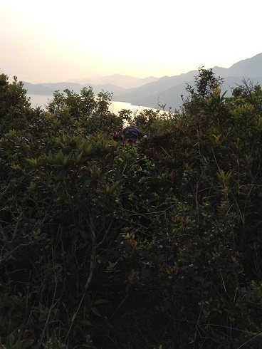
Continue down a bushy gully, in between the climbers in the photo below.
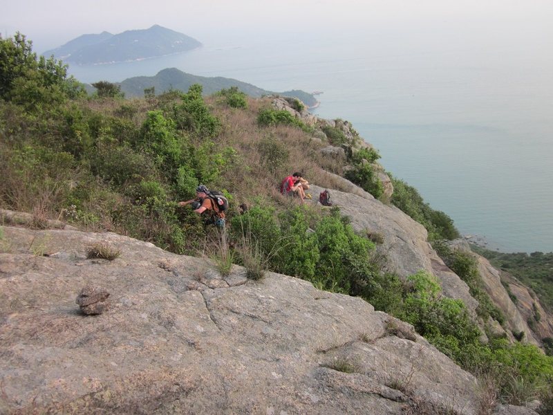
That will take you to another faint path, where an exposed scramble leads out to the triangular platform. This last part of the approach is easy, but loose, and a 200' drop immediately below. There is an extremely worn looking handline leading down to the platform.
There are LOTS of bolts on the platform. The anchors on the right hand side (facing out) will take you to Via Etrusca and Tin Hau.
Total distance from Pui O bus stop to the summit is roughly 5 kilometers, with a 213 meter elevation gain along the way.
large formation in the distance.

If traveling on foot from Pui O, follow the walkway, making sure to stay to the left of the water channel. If arriving by taxi, you want the entrance to the park on Chi Man Road.

Follow the stairs up the path to the summit. The first set of routes top out on a triangular platform, visible directly below the summit.

There was a rap station from the summit to the platform, the station is gone as of 2015. Instead, continue walking downhill to an inobvious path on the right hand side.
Continue down a bushy gully, in between the climbers in the photo below.
That will take you to another faint path, where an exposed scramble leads out to the triangular platform. This last part of the approach is easy, but loose, and a 200' drop immediately below. There is an extremely worn looking handline leading down to the platform.
There are LOTS of bolts on the platform. The anchors on the right hand side (facing out) will take you to Via Etrusca and Tin Hau.


Total distance from Pui O bus stop to the summit is roughly 5 kilometers, with a 213 meter elevation gain along the way.
Weather Averages
|
High
|
Low
|
|
Precip
|
Days w Precip
|
Prime Climbing Season
| J | F | M | A | M | J | J | A | S | O | N | D |
| J | F | M | A | M | J | J | A | S | O | N | D |
Photos


All Photos Within Temple Crag
Most Popular · Newest · RandomMore About Temple Crag
Printer-FriendlyWhat's New


0 Comments