Dave's Wall Rock Climbing
Use onX Backcountry to explore the terrain in 3D, view recent satellite imagery, and more. Now available in onX Backcountry Mobile apps! For more information see this post.
| Elevation: | 552 ft | 168 m |
| GPS: |
41.14497, -74.16583 Google Map · Climbing Area Map |
|
| Page Views: | 12,999 total · 107/month | |
| Shared By: | kenr on May 14, 2015 | |
| Admins: | Morgan Patterson, SMarsh |
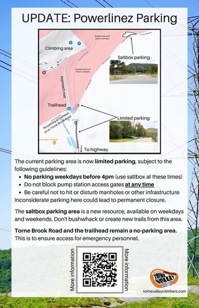
 Access Issue: As of November 2021, there are new parking arrangements. Please follow this guidance.
Details
The current parking area is now limited parking, subject to the following guidelines:
No parking weekdays before 4pm. (Use Saltbox Parking Area at these times).
Do not block pump station access gates at any time.
Be careful not to hit or disturb manholes or other infrastructure.
The Saltbox Parking Area is a new resource, available on weekdays and weekends. Don't bushwhack or create new trails from this area.
Torne Brook Road and the trailhead remain a no-parking area. This is to ensure access for emergency personnel.
Inconsiderate or illegal parking here could lead to permanent closure.
Description

Small section of cliff with interesting overhangs. Just west from Three Bears (which does not have overhangs). Bottom 20-25 feet of the wall is steep, then gentle for another 20 feet or so above.
For setting up Top-Ropes, a long static line is needed, with some skill in dealing with the upper gentle section.
Simplest way to reach top of cliff is to walk west along base past Munsee and Ramapaugh boulders to the junction with the trail up to Good Books wall. Turn Right onto this trail and hike/scramble up steep hill. A little way horizontal on trail, then head off right gentle uphill to reach top of Dave's Wall cliff. The top section is much less than vertical, so requires some careful scrambling down to get the anchor point into a good position for belaying the top-roping from the bottom of the cliff.
Getting There

From the normal Powerlinez parking, walk to the bottom of the Tower Wall , then 50 yards west on a flat (passing under the Three Bears slab) to reach the bottom of Dave's.
(GPS latitude longitude approx N41.1450 W74.1658)
Another way to get there is about 200 meters up the easier normal road/trail toward Basilisk and Good Book (about a 150 meters West after a trail goes off up to Tower Wall), turn Right (N) off the dirt road and scramble up a little directly under the electric power tower (GPS lat long N41.14443 W74.16625), about 40 meters North, then bear Right and go flat on trail about 50 meters ENE, look N and see Dave's Wall.
Classic Climbing Routes at Dave's Wall
Mountain Project's determination of the classic, most popular, highest rated climbing routes in this area.
Weather Averages
|
High
|
Low
|
|
Precip
|
Days w Precip
|
Prime Climbing Season
| J | F | M | A | M | J | J | A | S | O | N | D |
| J | F | M | A | M | J | J | A | S | O | N | D |
Photos
All Photos Within Dave's Wall
Most Popular · Newest · RandomMore About Dave's Wall
Printer-FriendlyWhat's New
Guidebooks (3)

 Continue with onX Maps
 Sign in with Facebook


1 Comment