To save paper & ink, use the [Hide] controls next to photos and comments
so you only print what you need.
Shirley Mountains
Wyoming
Description
The Shirley Mountains are a minor central Wyoming range[tops = 9153] that bounds the southwest side of Shirley Basin. The Shirley Mountains are about 29 miles north west of Medicine Bow, WY. The escarpment/fault faces the Shirley Basin in an "L" shape fashion with the base's east end running west and then turning north. The granite core is the red wall facing east. Among those formations topping the visible granite is a limestone wall above 8000 feet. Along the east west escarpment are some mounds, towers pinnacle and walls with steep faces.
Although only one climb is written up -- posted; there are 18 limestone climbs at the Cliffs Beyond Difficulty along its west facing cliff. The easiest climb 5.6 is on the far right and goes to the big caves. The hardest climb 5.12b is on the left end. The rest of the climbs range from 0ne 5.8 to mostly 10's and 11's . Lengths very from 50' to 75' and are well bolted with ram horn top anchors.
Mt Bikers: There are many 2-tract roads on this flat top that make loops and have cool temps and not to difficult for casual mountain biking. Consult the Google map of this region in high detail to see the many 2-track options.
Cavers: There is also a limestone cave out this way. Consult with Rawlins BLM office for key to access.
Safety: Safety trumps Leaving No Trace in this area. You will find hangers on bolts.
Getting There
See MAP 1: Take WY 487 north of Medicine Bow, WY for 21.5 miles to jct WY 77 [the old paved road] and go west 9.2 miles to jct 102 and go west on a gravel road. Drive 2.3 miles taking a right to stay on Rd 102. After 6.3 miles go straight [west] at jct 103 staying on Rd 102. Drive 1 mile and take a Rd 3115 south passing a campground. After going uphill and continuing on the flat for 3 1/4 mile you may be able to spot point 8172 to your left. Map 2 covers in more detail the region south and east of here. If you are hiking to the Red Granite Blocks that face east start hiking here, otherwise proceed along Rd 3115 to the rocks facing north. Don't miss the pasley painted abandoned hippy school bus further south on Rd 3115[free camping if still here].

[Hide Photo] A saw-whet owl posed for many "no flash" shots of himself in a very dark dense canopied limber pine forest on the slope and rocks of the east facing escarpment. Shutter speed was 2.0 sec and this…
[Hide Photo] A closed look at the north facing escarpment mounds and blocks of steep rock.
[Hide Photo] A pinnacle on the east facing escarpment.
[Hide Photo] Looking at the north facing escarpment while standing on top of the east facing escarpment. It is not as continuous of a rock band but there are some steep mounds.
[Hide Photo] The limestone rim that occurs where the escarpment changes directions from north facing to east facing.
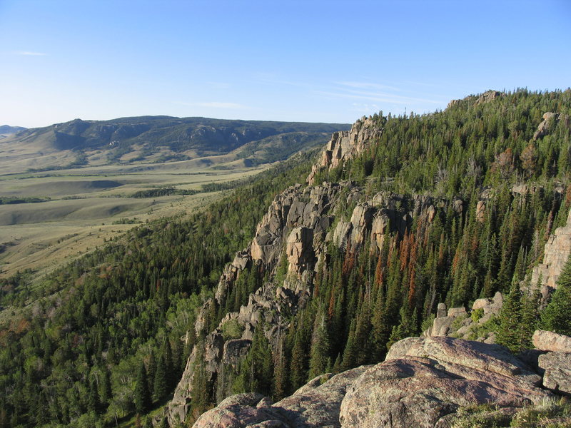
[Hide Photo] The east facing granite escarpment of the Shirley Mountains. The grassy lowland is mostly private.
[Hide Photo] MAP 2: A topo map of the NE facing escarpment of the Shirley Mountains and BLM Rd 3115.
[Hide Photo] MAP 1: Shirley Mountains access from jct 487/77 21.5 miles north of Medicine Bow, WY.


 Continue with onX Maps
 Sign in with Facebook


Spearfish, South Dakota