Mount Yukla
Alaska
> S Central Alaska
> S Central Alaska Ice…
Description
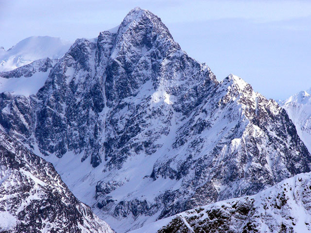
Mount Yukla is one of the gnarliest peaks in the Chugach. From Anchorage, it is one of the best places to climb big, hard lines in a relatively short time without paying for a flight to the Ruth. While its elevation isn't anything to squak about by Alaska standards, Yukla is a beast of mountain. The northern side has well over 4000 feet of elevation gain.
In the past decade, Yukla has become the hot spot for a small group of local alpinists. There are at least ten established routes on Yukla, with only one of them being anything close to a walk up.
John Kelly has been most prominent in the development of routes on the northwest side, out of Icicle Valley.
All technical routes have required at least one bivy or "in a push" climbing of around 24-48 hours or more.
The alpine season for Yukla is typically from late September to early April.
New route information appears in almost every American Alpine Journal from 2006 to 2012, with many informative photos and tales of suffering.
Specific route information will be added in the future.
Getting There
From Anchorage, drive North to Eagle River and then to the Eagle River Nature Center, 12 miles down the road.
Hike 5.5 miles to Icicle Creek and hope to god you locate the proper climber's trail which is sporadically marked with flagging, cairns and cut branches. (1.5-2 hours from trail head)
Do not go straight in to Icicle Creek if possible. While it is possible to get up to the valley from here, it is very cliffy, steep and exposed.
When looking straight at Icicle Creek Drainage from the river, you will see a prominent buttress on your left. Navigate through a grove of cottonwoods to the base of the rampy buttress. Look for a gully (the general path of least resistance), occasionally marked by cairns and cut limbs. This is the best and safest way to access the drainage.
Eventually you will find yourself atop the buttress and over the steep cliffs of the lower drainage. Continue following the faint trail, weaving up and down, through thick alders. If you lose the trail, backtrack and pick it up again or suffer at your own will.
Eventually you will cross three prominent gullies which can be either scree or avalanche debris depending upon the season. Later you will drop down towards the creek, aiming for a large single cottonwood tree towering above the mess of alders. Follow the creek up and around (on the left side) as it begins to open up and become less of an alder bash.
Look for the large, obvious boulder AKA the "Boulder Bivy" on the left at the mouth of the valley. Rocks have been piled up as wind blocks. Ample water can be found in a small creek below the boulder. (5-10 hours from trail head)
Plan on anywhere from 5-12 hours to reach the Boulder Bivy depending on conditions and luck with staying on the faint trail. Note that getting up Icicle Drainage is no easy task, especially if you are not sure where you are going. Many avid Chugach hard men have called this the worst bushwhack they have ever seen. If not on the narrow trail, expect an endless labyrinth of tangled alders, slick scree and devil's club.
Good luck.
Routes from Left to Right
| Route Name |
Location |
Star Rating |
Difficulty |
Date |
|
●
Gank'd and Slayed
|
|
|
WI6 M5 A2 Steep Snow
Aid, Mixed, Ice, Snow, Alpine
|
|
●
West Ridge
|
|
 3
3
|
|
5.8 5b 16 VI- 15 HVS 4c Mod. Snow
Trad, Snow, Alpine
|

[Hide Photo] The incredible 4,500' north face of Yukla
[Hide Photo] Pablo Excalibur and (pre med) Dr. Matts Peters enjoy the boulder bivy with a view-Feb .2018
[Hide Photo] A particularly blustery and stormy day on Yukla
[Hide Photo] The three routes (DJs, History and Gank'd) on the northwest face from the base
[Hide Photo] Aerial view of the north face of Yukla. The Baranow Couloir is clearly visible on the right.
[Hide Photo] The north face of Yukla from the Eagle River overlook. Micah McGuire photo.
[Hide Photo] Close up of northwest face in snowy conditions
[Hide Photo] The northwest face of Yukla. Three lines have been climbed on this face. Most People are DJs (Steep upper ramp) The History of Things to Come(direct) Gank'd and Slayed (right ice line) All…
[Hide Photo] The Positive Side of Negative Thinking. Put up solo by John Kelley in 2006 or so. Wi4+, 400m.


 Continue with onX Maps
 Sign in with Facebook


Palmer, AK