Montana
> Northwest Region
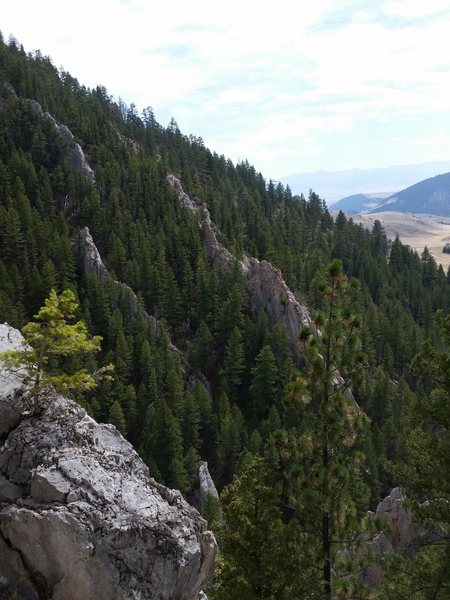
This area consists of large grey and blue Limestone fins. The climbing tends to be vertical or lower angle, with lots of the classic limestone pockets, jugs, and heavy on the crimps. Tends to be a bit steeper than it's neighbor Mulkey Gulch. The rock can be extremely solid or total choss depending on which side of a fin you are on, although there is plenty of great rock and good climbs to choose from. This area is a tight canyon so it can get rather cold in the winter, late fall, or early spring. On the other hand, the middle of summer can be extremely hot, but chasing shade can always find something climable. Probably the best conditions are in late spring through early fall.
Camping can be found at Bearmouth RV Park on the frontage road near Exit 138. This RV Park has RV and tent camping and a camping cabin all on the banks of the Clark Fork River. The bathrooms have hot showers, tent sites have water nearby, RV sites have water & electric hookups, there are picnic tables and fire rings, prices are reasonable. A small store and reopening the motel rooms is planned for 2012. Check out the website for more information
bearmouthrvpark.com.
There is also camping about 18 miles away at Beavertail Hill State Park just off of I-90 at Exit 130. If you want to extend your stay in the area, drive the Pintler Scenic Route beginning in Drummond and check out Philipsburg and Georgetown Lake. Visit Garnet Ghost Town, about 15 miles from the RV Park. Ride your bike on the frontage road from Bearmouth RV Park to Drummond (32 miles round trip) or make it a 100 mile round trip ride up to Helmville and the Nevada Reservoir. There is great fishing on the Clark Fork River. The closest beer, food, and gas can be found to the east in Drummond, MT, but as Drummond is a small ranching community options are limited. Missoula, which lies 45 miles to the west has a much wider variety of options
From Missoula, take I-90 East towards Drummond. After about 35 miles you will come to the Bearmouth exit (#138), take this and go left under the interstate then turn right. Continue down the frontage road on the north side of the river, for about 15-20 miles. You will pass Bear Gulch and Mulkey Gulch before Rattler Gulch. Look out for the signs on the left and right sides of the road. Once you get to Rattler Gulch Rd., take a left and continue on the dirt road for a few miles until you come to the limestone right off the road. The majority of the routes are before the main sign which is before the yellow cattle guard. Look for the pullout on the left side of the road as you approach the area from the south and spot the main, visible buttress (with Orange Peel). This is the closest and nicest area to warm up. Conversely, park up by the area signs where there is a small pullout for the more scattered and obscure climbing if coming from the north.


 Continue with onX Maps
 Sign in with Facebook


Missoula, MT
-Kurt Jul 19, 2017
Missoula, MT
Missoula MT
open.spotify.com/episode/1E… Jul 1, 2020
Your mom
Keep an eye on the ground; you're likely to find some cool stuff! Sep 22, 2020
Las Vegas, NV (2 yrs) and…