
 Continue with onX Maps
 Sign in with Facebook


Greens Cliff Rock Climbing
| Elevation: | 2,675 ft | 815 m |
| GPS: |
44.0358, -71.3996 Google Map · Climbing Area Map |
|
| Page Views: | 142,474 total · 780/month | |
| Shared By: | M Sprague on May 6, 2010 | |
| Admins: | Jay Knower, M Sprague, Jeffrey LeCours, Jonathan S, Robert Hall |
Description


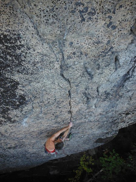
The rock appears to be mostly high quality with sweeping aesthetic features including long cracks, corners, roofs, moderate and fierce slabs, flake systems, steeply overhanging jamb cracks, granite pockets and maybe even potential for a few overhanging sport climbs. Many classic lines await FAs. For those looking to do established lines, there is now a good collection of high quality routes from 5.7 to 5.13.
The Walls
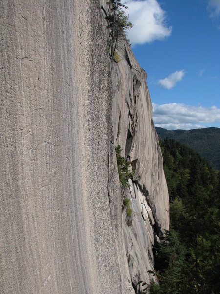
The Main Wall is a sweeping band about 1/3 mile long and up to approximately 250 ft tall, of quality granite. It is similar to the best found in N Conway, but without the slick polished feel. It faces south east, so gets morning sun and has great views of Mt. Tremont and Owl's Cliff mountainproject.com/v/new_h… to the north east and to the south and south east, Mts. Tripyramid and Chocorua.
To the left, past two slabs with no known routes but potential, is the area known as The West Wing, a large, tall shoulder of rock. The Wing's right side is The Alcove, a section of overhanging yellow rock tucked into the steep hillside, surrounded by tall hemlocks. The Alcove is a little raw, with some sections of rotten rock and in need of further cleaning and some anchor upgrades, but it also has some of the steepest lines, including the old aid line jam crack '357', recently freed at the mid 13 grade.
Around to the right of the Main Wall are the Northeastern Crags, a collection of partially developed walls with an especially scenic overlook of the Sawyer Pond basin and the shortest approach. Here you will find high quality, mostly 1-3 pitch cracks, from fingers to offwidth/chimney and the really fun technical 12a/b arete Bigfoot Was Here.
It is a little far to go hauling crashpads, but if you are into backwoods bouldering, there are quality boulders up to 30 ft tall scattered in the forest below the crags, especially below the Main Wall and the West Wing.
Around to the left, more facing south south west is the large, good quality Meadow Brook Slab. It is on the same formation but fairly distant and has a different approach. Chuck Woodman and others have put up routes here up to 3 pitches. (we need more info)
A Little History
There are references in Charles E. Beals' book 'Passaconaway in the White Mountains' to Greens being a popular destination for hunting or picnicking in the late 1800s, but I haven't found any mention of climbing at Greens until the 1928 AMC expedition lead by Lincoln OBrien. They made at least one visit to the cliff, "making it up 100 feet, but were unable to find a route to the top of this magnificent cliff. No other route could be found; the smooth, massive slabs seemed impregnable." Im not sure where they tried, but Justin Preisendorfer found old pins while climbing Fireside Crack. It seems the trail cut in by the Passaconaway Mountain Club that the AMC folks used was not long maintained, which probably put a damper on further attempts.

It wasn't until almost 50 years later that Jimmie Dunn and Michael Macklin most likely made the first full ascent, by way of the classic Stewart's Crack, in 1975. In 1993 John Strand and Gerry Lortie climbed the very difficult slab, Black Flies Consume Jim Dunn as a first pitch to a possible 3 pitch wild looking line, ground up and hand drilling free on the lead. Michael Hartrich and Matt Peer climbed the thin Ginsu Flake, without the bolts and got down by soloing off right to a brushy corner. In 1994 Ward Smith and Paula King explored in from the Sawyer pond. They didn't quite make it in to the Main Cliff, stopping instead after much thrashing about at one of the walls of the Eastern Crags, to put up perhaps the first route at Green's using the top down approach, Premarital Blisters, a great looking 5.11c thin face and crack line.
Later, Steve Dupuis, Aaron Rashaw, Jamal Lee-Elkin, Tim Martel and Justin Preisendorfer and others traveled out, making more regular visits, battled bears and, usually ground up, aided or freed a number of dramatic routes that just beg to be climbed when you see them, like the big second pitch flake system of Green Party and the 200 foot finger and hand crack Greenpeace, and '357'. It then lay mostly quiet for a while.
In early spring 2010, after observing and wondering about Green's for many years while climbing at Owls, I finally skied and snowshoed over to check it out and was hooked by the beauty of the cliff and the new route potential. The year saw a flurry of activity. With the help of Dima Shirokov, Amy Colburn, David Powers, Matt Elliott, Randy Garcia and others, Greenpeace and Green Party both got freed, 8 new pitches were established and a bunch of new projects started.
2013 saw increased visits, with some notable ascents being the freeing of 357 by Conor Cliffe and Tom Draper and the bold ground up onsight first ascent of a line through the dramatic second and third pitch terrain above Black Flies... (still un-named) by Bayard Russell, Ray Rice and Cliffe. Also of note, after years of biking and hiking in the long way (doh), a much shorter hike in from the north was found that avoided any horrible thrash, making Greens now barely an outback area, especially the Northeastern Crags. As a result, climbing at the Northeastern Crags became much more feasible (Greens Light, as John Strand calls it) and seven quality new routes went in over there.
There is now a good collection of established routes available with lots of potential for more. If it was a bit closer to the road this area would likely be one of the main climbing destinations of New Hampshire. Luckily it isn't, so you can get away from the crowds and find top quality new lines to explore. Top that with a great bivy spot on a ledge under a huge protective roof, a very picturesque location , adventurous friends sharing a rope or a bottle of wine around the fire afterwards and you should get the picture of Greens. (We'll forget being eaten alive because you came out in the wrong time of Spring and forgot your bug suit, ha ha)
2017 The hordes arrive.
Getting There
May 2024 update - Sawyer River road is CLOSED for the summer of 2024 due to washed out road from the rains of Dec 2023. WMNF believes the road will remain closed for at least most of the summer.
It used to be that an approach to Greens would require a long slog by bike and hike, but recently a quick and scenic way in on foot has been figured out by coming in from the north via Sawyer River Rd. Approach times run from a little under an hour to the North Eastern Crags, to a bit over an hour to the Main Wall and maybe 1 1/2 hr to the Alcove/West Wing. Meadowbrook Slabs have a different approach: See its page for directions.
Drive south ~ 4 miles on the dirt Sawyer River Rd off of 302 at Hart's Location, all the way to the last gate. Park in the large clearing on the right. Continue on up the road on foot, past the gate a few hundred feet and take a left onto Sawyer Pond Trail, immediately crossing the river via the footbridge. Continue along the trail like you were going to the pond and in about 5 minutes you come to a second, smaller bridge (the boardwalk right after the first doesn't count). Leave the trail just before crossing this second bridge. Treading especially lightly, cut right into the woods, initially staying near the bank of the stream for maybe 50+ ft, then bearing away from it a little (heading directly south) to follow a shallow, somewhat nebulous drainage a couple hundred feet. Move to the left side of the drainage, passing by two huge yellow birches that almost cross each other. It is important to be careful to not beat in a trail here or mark it. Lots of yahoos head into the pond and there is no sense in drawing them up to the crags to leave their poop and beer cans. Tread lightly

Once in a few hundred feet, around N44.05243 W71.39998 A climber's trail has usually coalesced. You are pretty much heading directly south and then bending more SSE, up the shoulder of the wooded ridge and the way should be easy to follow, with occasional cairns. Along the way you will cross two overgrown skidder trails, making very short jogs on them to the left before resuming up the hill. Once up on the ridge you continue along it heading south, with some great views through the trees out over the very scenic Sawyer Pond basin, with cliffs all around. At around N44.04330 W71.39683 you will get to a small boulder with the roots of a large yellow birch tree growing over it, with a cairn on top or in front of it. Here is where you branch left for the Northeastern Crags, or right if you want to save a few minutes and take the most direct path to the Main Wall and Alcove.
For the Northeastern Crags bear left, over a small rise then down a shallow coll and then turn right, now traversing below the gradually growing cliff line that eventually becomes the Bigfoot area. (You would go down the coll and bear left instead to get to the base of The Knoll) You will be traversing the hillside south for about 5 or 10 minutes until you see the obvious sharp arete of Bigfoot in front of you. It is about an hour from the car to Bigfoot, 40 min if you hike fast.
For the Main Wall, If you want to skip the NE crags and get there directly, instead of heading down the coll, you would bear to the right from the boulder cairn and generally continue snaking uphill along the ridge line above the Northeastern Crags. Once the trail tops out and begins to come down a little, you may see a few flags coming up the hill on the left from the Beanstalk Wall decent gully. Ignore them and keep bearing right, around a little plateau, and you will be dropping down along below the right end of the Main Wall, passing through some boulders just before you get there. Figure an hour to hour and a half from the car to the Main Wall. From the NE Crags to get there, go to the left side of the Beanstalk Wall and continue traversing left over to the separate buttress with the route Encour du Bottom feeder. Scramble up the gully just left of that route and continue up the hill a few minutes and you will run into the overland trail. Take a left and in ~ 10 minutes you will be at the Main Wall.
The Alcove/West Wing is a further 15-20 min left(west) from the Main Wall. See directions in the area page.
Most of the way is very clear going, but it is probably not a bad idea until you are familiar with the area to carry a GPS/map and compass in case you get off track. Sawyer Pond Road is seasonally closed for snow, but you can bike or ski the 4 miles if you still really want to get in. When it is open it is usually well graded and fine for most cars
Forest Road &Bear Notch Rd. Status -note, not always immediately updated
Classic Climbing Routes at Greens Cliff


Weather Averages
|
High
|
Low
|
|
Precip
|
Days w Precip
|
| J | F | M | A | M | J | J | A | S | O | N | D |
| J | F | M | A | M | J | J | A | S | O | N | D |
Photos


All Photos Within Greens Cliff
Most Popular · Newest · RandomMore About Greens Cliff
Printer-FriendlyWhat's New
Guidebooks (1)


10 Comments