Jungle, on the Aquarius Plateau
Utah
> S Central Utah
Description
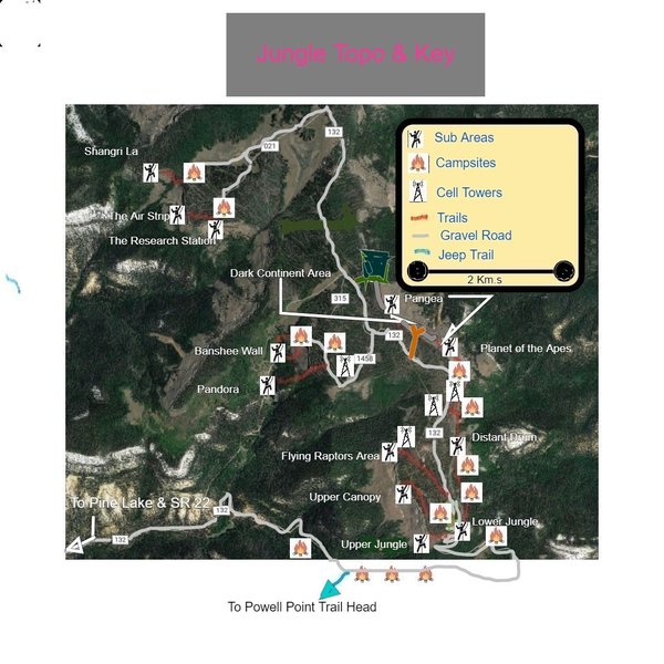
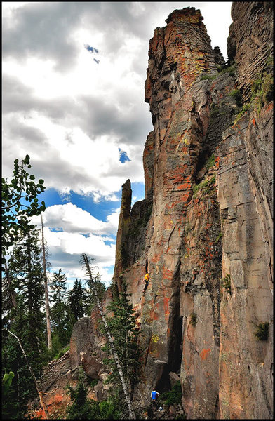
This is sharply-broken volcanic rock from the late Tertiary (an Osiris Tuff) forming two bands of cliffs, the south or left of the road, the Banshee Wall, Pandora, the Flying Raptor's Area, Upper Canopy Area, and the Upper Jungle. North or right of the road areas are the Lower Jungle, Distant Drum, Planet of the Apes, Pangaea, and The Dark Continent Area (not reachable by the trail but by the road above). There are many excellent, long cracks to be developed. There is also a lot potential for bolted sport routes. As of Sep. 2017, there are well over one hundred eighty routes ranging from 6s to 13s with at least one route at every grade in that range and a few multi-pitch routes as well as a few towers (Kong, Authors, Togo with a register, Dinka, and Kestrel). For those of you wishing to boulder, there is a small bouldering area known as the "Jungle Grotto" down near Pine Lake. These boulders are composed of different and softer but doable rock.
This is an alpine setting (10,400 ft.) and one of the highest (drive up to) crags in the country. Thunder storms can come and go quickly especially in late July and August. The north band of cliffs have two towers, Authors and Jared Diamond, that can provide shelter from the storm. Lighting strikes on the upper reaches of the cliffs can bring rocks down. The closest hospital is in Panguitch 50 minutes distant. The Tropic First Responders have been briefed on the area and a 911 call can be made from the parking areas. Give them the area and route you need help on to speed (1.5 hr.s) the stokes stretcher to you.
CAMPING: primitive campground near Pine Lake or many off-road options right near the crag are available (see topo below).
FOOD: Can best be purchased at Ruby's Inn: there's a grocery store, and - BONUS - a full range buffet in the restaurant.
SPIRITS: Are hard to come by in the "Empire of Utah"... There is a full State liquor store in Panguitch (1 hour, 30 minutes), or a limited State liquor store at Ruby's. Beer here is "near beer" so come prepared, stock up before you cross the state line.
BOULDERING: Check out the "Jungle Grotto" but DO NOT MISS the lines under "Jared Diamond Tower" found in the "Distant Drum Area". There are many FAs to be had in both areas!
NOTABLE FLORA AND FAUNA: Subalpine Firs and Bristlecone Pines (a.k.a. Foxtail Pines locally) as well as Black Bears, Mountain Lions, Mule Deer, Elk, Marmots, Pikas, Black Rosy Finches, Magnificent Hummingbirds, Blue (Dusky) Grouse, Swifts, many species of Owls, most of the raptors, including the Bald Eagle, Golden Eagle, California Condor and the Peregrine Falcon to name but a few.
ROCK QUALITY: There are some really great quality rock sections to this crag and some loose parts, as well. Be advised of the possibility of rock fall from high up. Blocks have weathered away from the main material (temperatures can range between 90 degrees F. and -60 degrees F.) and precariously await their transition from potential to kinetic energy.
Interestingly, there was a debate regarding the exact origin of the material we climb. Some believed the crags were formed by volcanic ash dropping out of the sky over a long period of time; a caldera many miles away being the source of the activity. Others suggest the volcanism to be local and that this is a lava flow or perhaps an old plug. Recently Dr. Jessica Ball, a volcanologist has given the definitive answer.
Cutting a cross-section and using a microscope to examine the pattern and composition of crystals has yet to be done. However, Dr. Ball found that the nicely formed hexagonal biotites which are easily seen were the tell. She believes that about 23 million years ago a violent pyroclastic eruption occurred from what is now called Monroe Peak some 50 miles north. This eruption sent "dense flowing ash" across the area in layer after layer. So, this densely-welded ash flow tuff is in fact what we are climbing. Examining the best visual display of geology on site can be done in the Lower Jungle on the north-facing route called "Knuckle Draggers Needed." There's at least 6 to 7 layers exposed and there is a paper, if not a thesis or dissertation here or down in "Pangaea" where a "hackle" has attracted much attention (see photos). A visual/hand lens inspection seems to reveal abundant biotite hexagons, quartz, sanidine, and amphibole. In any event, there is good climbing to be had.
ROUTES: Due to the nature of the rock, bolt placements may not always coincide with your views. Judicious placements have been set, with safety being the primary concern. What may appear to be a perfect, sheer face, may actually bear a hollow, brittle base. Among the many things that are considered while setting, the "hammer-hollow" test has been determined as the most measurable way to rule out poor rock quality. While climbing please understand that routes may not follow a direct path and anchors may be placed prior to the top of a crag, all of which keeps everybody safer. Route setters should use camouflaged hangers, chains or shuts, and 3/8th" X 3" bolts seem to work best though occasionally we use the 3.5" long for the lesser quality rock. EDIT: As you may well be aware, bolts, hangers, and how they are placed are all undergoing a metamorphosis. So stainless and 1/2" may be all you can find these days. In any event, avoid mixing bolt/hanger metals. Three to four inch depth is still plenty for the vast majority of rock here and some really good sections can go shorter.
ETHICS: My once conservative purest standard has softened. The Jungle and my old age have schooled me. There are a few lines here with bolts and cracks side by side. In the beginning we would pick the best clean trad lines. No problems here going ground up. Then we also saw good trad lines that would need cleaning. Sometimes we found that the material in the cracks was endless and deceptively unstable. After scouring out a place for a couple of pieces, we would stand on aid and do more crack cleaning only to have our pro move or fail in the yet to be reached good rock. So then came a bolt to complete the ground up cleaning and hopes that the face to the left or right would work out into a sport alternative. Or, we thought the crack would never clean up and remain unsafe and the face moves were promising and nearby. After a fall with the drill and a small hole in my shoulder I have concluded the following: 1) Due to the extreme weathering that goes on here some routes are best set from the top down. Clean the line, establish the solid stances, mark out the clips remembering those shorter folks, and place bolts based on how good the rock is on this particular line. This also keeps your belayer happy. Many belays are from a narrow trail with few to no options for protection while the leader is cleaning on a ground up campaign. There are some very large blocks that often need removing. This type of top down plotting identifies future weathering issues and establishes a safe and lasting route. 2) If the line is clean and on good rock to begin with, set it from the bottom up using camouflaged hardware. The locals love to site-in the new scope on the bright and shiny hangers. Also, please avoid crowding routes together here. There is so much rock here that one need not look far to find an isolated spot for an awesome new route. So before judging a line with a crack and a bolt, know how much cleaning work sometimes had to go into getting the route climbable. Avoid my mistakes by just doing the work from the top down and create a durable, safe route without bolts and cracks together.
ENVIRONMENTAL CONCERNS: Stay on trail, leave clean campsites with well doused fire pits, crags without any trash or shit, drive only on roads, double tracks, and please do not forge into a new spot in the forest. Continued access depends on you!
WEATHER: Thunderstorms can be a problem but the rock dries out fast... not so much the road. If windy head deep into the "Lower Jungle" or even further into the "Distant Drum Area" and you can climb in calm albeit with the trees screaming above. There is more shade in the morning in the Upper Jungle, Upper Canopy, and Flying Raptor's Areas though by 11:00+ am or so it grows hot... move into the north facing routes in the "Lower Jungle" or "Distant Drum Area" or even further into the "Planet of the Apes or Pangaea Areas" where many fine routes can be found in shade or soon to become shady. These areas are the the most protected from the sun. The fall season may be the most pristine time to climb here and can last late into October and in 2012 we were climbing in early November.
WHAT TO BRING: In terms of gear, a set of small to medium wires, at least a set of double 00 Metolious through BD 5s and perhaps one 6. Also, BD 4s are needed in threes on some of the classics. Bring four shoulder length and two five ft. runners along with a dozen QDs. Always have a light weight rain jacket and perhaps rain pants along. Speaking of clothing, shorts are a mistake! Long pants in any color but black (the flies here LOVE black) with a high top approach boot is recommended. Firewood is not a problem but thunderstorms are, so, bring the rain fly. Water is around in creeks on the drive up or in the Pine Lake Campground. Please bring a shovel to bury your shit! Wear a helmet unless you are really confident and 60 meter ropes (fat ropes are safer due to the sharp edges) will suffice on almost all of the routes. When you get back home please leave comments and ratings on what you did.
ROAD CONDITIONS: On occasions a flash flood will take out the road just above the Pine Lake Campground. There is a back way in. Take the forest service road out of Widtsoe then make a sharp right at the BIG intersection back to the Jungle and "drop in." High clearance!
SHORT CUTS: To more quickly access some of those newer quality routes established far out in the Distant Drum Area or even farther out into the expansive Planet of the Apes Area, and Pangaea Areas, check the beta photos on those area's cover pages. Here you find mentioned a down chute at the interface between two of these remote Areas. Though not dog friendly, it is an easy (5.4) way to reach the trail below where many terrific new lines are within a short walk. The chute should be approached as having the possibility of rockfall. Therefore, use the hardware provided on the walls and avoid the loose floor. Travel down in pairs staying close together making sure nobody else is in the bowling rock-ball funnel. Between the small/old cell tower on the east side of the road and the parking spot for the Dark Continent Area is a wood cairn marking a small double tract that leads east to a campsite and another down. There is a short zip line from a tree to an anchor on the face of an attached tower. Here two 60 meter ropes gets you to the end of Pangaea. You can take your pack down and stash it in the many overhanging dry areas making the exit and next day approach even more enjoyable. Or, if you are worried about food smells attracting vermin and/or bears, hang the pack off any one of the many routes lower bolts. In the frontier between the Lower Jungle and the Distant Drum Area Authors Tower is a great option for saving effort. Boulder up the overhanging crack and place a high piece then lower down. Haul up your packs and tie them off. The Tower keeps the weather off and the roosting owls high up will keep the rodents away. Then further down in the Planet of the Apes there are caves to do the same. In the Pangaea Area a good option is to hang packs behind Dark Tower. People are not expected to be an issue here.
When arriving at a chain anchor, rather than untieing, threading, and retieing simply open the quick link and put your rope through. With as few climbers visiting the Jungle, this will be fine. If you are working your line then use your own gear. Always have a 3/8th quick-link to replace the seldom seen worn hardware.
If you worry about the rain drops falling from the cloud symbols above...well...don't. Set a good tent with a rain fly, stash some near by fire fuel under a tree and leave early in the morning to climb. A shower may show up around noon and most likely be gone by 2:30 pm. Then climb as long as you like. There are seven campsites complete with fire rings, sitting stumps, and tent sites very near the crag for quick weather exits.
Tips, Concerns, and Gifts
There are four new areas that should be described in the opening, however, due to new word count max.s, they will be mentioned here. All in generally the same geographic area and each one facing a different cardinal direction (see approach maps as well as this cover page "Directions" map) these areas add a new dimension to the Jungle. Off of USFS Rd. 021 and only 4 miles north of the Lower Jungle parking area, The Research Station is the most southerly of the three and faces SE. Around the cliffs corner is a long stretch of varied possibilities in the Air Strip. This area faces west. Then the real gem with the best rock in the Jungle is the most northerly of all areas and faces south is called Shangri La. There was a pristine campsite and trail here that has recently been soiled a bit by the addition of cows. Long hard lines exist here. And lastly, a new area to be only mentioned in the upcoming guide book.
More tips: Go slow reaching these new areas in that the rocky road can bruise a tire. Two wheel drives have been here.
Check with USFS for current campfire regulations...do not mention climbing but camping.
Concerns: Fires are scary in these dry conditions! Avoid poorly managed campfires, target shooting, and cigarettes not snuffed.
Gifts: Looking for an old stokes stretcher to stash in the J in case we climbers need to haul our selves out to where first
responders can take over. If anybody has a way to to help here we all would be appreciative. Thanks!
Getting There
If you are coming from the north or east and Goggle Maps or some such BS directs you another way in, like to Widsoe, (this is the emergency exit) then you are making a mistake! Follow the directions below from which ever direction you travel from. You SLC craggers might consider this route down. I think it is the fastest as well as the most scenic. Take 15 south to Scipo. Then 50 to 260 toward Aurora (a speed trap). South of town there is a fork in the road. No matter what the sign says, go right on the unsigned Interchange Rd. that takes you directly to HW70. South here to HW89 and through Panguitch. Otherwise, everyone should take UT Highway 12 toward Bryce Canyon National Park; at BCNP junction, turn northeast onto Highway 22 (toward Antimony and note the unreasonable but enforced speed limit of 40mph); turn southeast onto Forest Service road 132 toward Pine Lake for 5.2 miles; continue past first exit toward Pine Lake and look for a LEFT TURN to Powell Point, (if you go straight you end up in the campground); soon you will see a great deal of white rocks, otherwise known as limestone indicating this alpine setting was once a seabed, continue on this road (132) for 5.9 miles until Powell Point jeep trail on right(143); Go PAST this jeep trail, setting odometer again and travel 1.9 miles, again, passing Powell Point jeep trail and PAST THE UPPER JUNGLE SCREE FIELD (looks like a single-car pullout on a hairpin turn) to the "Lower Jungle" et al. parking areas on right, or around the corner and up the road 100 meters to the "Upper Jungle" and "Upper Canopy" parking area where the approach trail leads DOWN to the climbs base trail (well marked). Just up through the switchbacks are the parking areas for the distant Upper Canopy lines and the Flying Raptors Area. Short approaches can be found at these parking areas to: 1) Lower Jungle, Distant Drum and depending on your athleticism, the Planet of the Apes Area and even farther to Pangaea from the northern/lower parking location and 2) from the southern/upper parking area to the Upper Jungle and some of the Upper Canopy areas. Although the more northerly areas, i.e. the northern part of the Distant Drum Area, the Planet of the Apes Area and to be sure, Pangaea and The Dark Continent Areas have shorter approaches from above on the plateau (see topos and descriptions within each area). The Research Station, The Air Strip, Shangri La, Pandora and The Banshee Wall all require a little longer drive past the Lower Jungle parking area, though shorter drive from the Dark Continent Area parking area. See topos on the areas cover pages. Click Topo key below pic.
Other Things to Do
Just down the road 1.9 miles is a 4 mile jeep trail that finishes as one mile of single track and a non-technical but great views mountain bike ride...about 10 miles in and out. Very nice! Also, father down and behind Pine Lake is the Henderson Canyon ride that will take you to the town of Tropic. About 10 miles of single track to dirt road that lasts for about 5 miles. A super trail in the upper section! This can be shuttled to skip the road. The fishing at Pine Lake is not bad but higher up, above the Jungle, are many small lakes thick with trout (mostly Brook, though a splattering of other species can also be caught). For those of us into fossils, you need not go far! Between the Powell Point Rd. and the small grassy meadow on the south side of the rd. just before you get to the crag you can see washed and smooth cobbles. Walk to the edge (east) and you can find 330 million year old invertebrate fossils such as sponges, bivalves, brachiopods, and corals to name but a few. These washed here interestingly from other cragging areas such as the Virgin River Gorge and Ibex many years earlier when those areas were higher and the Jungle was lower.
![North faces in the Jungle are exceptionally colorful with many species of lichens. This route is in the Lower Jungle and is called Daniel Quinn. <br>
<br>
Boissal Photo.]()
[Hide Photo] North faces in the Jungle are exceptionally colorful with many species of lichens. This route is in the Lower Jungle and is called Daniel Quinn. Boissal Photo.
![Old Man Rosco- Relaxing in the Jungle.]()
[Hide Photo] Old Man Rosco- Relaxing in the Jungle.
![Welcome to the Jungle]()
[Hide Photo] Welcome to the Jungle
![The beautiful Pine Lake on the way to the Jungle (seen on the horizon on the high right).
<br>
By David Crane.]()
[Hide Photo] The beautiful Pine Lake on the way to the Jungle (seen on the horizon on the high right). By David Crane.
![The shadow people LOVED visiting Powell Point on the Aquarius Plateau, after an awesome day of climbing at the Upper, and Lower Jungle. : )]()
[Hide Photo] The shadow people LOVED visiting Powell Point on the Aquarius Plateau, after an awesome day of climbing at the Upper, and Lower Jungle. : )
![The Lower Jungle.]()
[Hide Photo] The Lower Jungle.
![A small portion of the the Upper Jungle]()
[Hide Photo] A small portion of the the Upper Jungle
![After the drought and before the snows, Deadly Amanitas were abundant. Gatherers beware! There is a reason for the name!]()
[Hide Photo] After the drought and before the snows, Deadly Amanitas were abundant. Gatherers beware! There is a reason for the name!


 Continue with onX Maps
 Sign in with Facebook


Your Mom
Small Lake, UT
Sorry to belabor the geology, I wanted to clear up the unconstructive comment from someone who has clearly never been there.
Look, if you don't like the rock quality at the Jungle, you better stick to climbing on plastic. Mar 15, 2012
Your Mom
mountainproject.com/v/king-…
I stand by my statement, I've never spent so many hours cleaning a single route. After 10 hours of hammering I still didn't feel the route was clean. There are some areas of the jungle that have less than stellar rock, but other areas are solid. It's OK, people will still visit this area and enjoy themselves immensely. Mar 17, 2012
SLC, UT
Vegas
Really? regularly -60F? Jun 17, 2013
PS 12/6/13 nearby Panguitch (4400 ft. lower) recorded a -36 F. Jun 19, 2013
I collected a couple of samples and will query my geologist colleagues for confirmation. Jun 28, 2013
n az
Small Lake, UT
The picture of the pillar in Slovakia looks a lot like a mossy Jungle. I'd say your assessment of the rock's nature is spot on. Jun 3, 2014
moab, utah
Wanship, UT
sandy utah
Southern Nevada
(edit 8/16/16) Some ass tore down the exquisite rock work (see comment above) forming a wind break and built in oven/fire place that formed a beautiful arch and was well designed. USFS? Why? Jul 23, 2016
Bellingham, Wa.
La Sal, UT
Arden, NC
Flagstaff AZ
St. George, UT
Southern Nevada
It was a cold bivy but great as always. Its such a special place, thanks for all the new development up there! Oct 13, 2019
Cuneo
Small Lake, UT
Scottsdale, AZ
Red Rock, NV
Some comments: given the density of descriptions for the areas, they can be somewhat confusing. My partner and I found an abundance of left vs right ambiguities and in some cases inversions. Additionally, some hike distances, route lengths, and bolt counts were off. And directing by way of terms like wood piles and man-made clearings adds further ambiguity in an area full of them. This was not too big of deal once learned, but added some extra confusion for a first-timer. Just don't get too bogged down in the overly-thorough descriptions.
Also, it's awesome to have campsites right at the approach trailhead for some crags, but only if you get that site. It's kinda awkward to park at someone else's campsite that barely fits their cars and then walk through their site to the "down-chute" approach. We didn't actually use any of the down-chute/rappel approaches, but largely because we questioned how we would get back out. Maybe we're just obtuse, but while the description was pretty clear how to get down these approaches to the crags, it was not clear how to get back out. Just a first-timers experience, really a great place to visit and climb! Jul 7, 2020
Las Vegas, NV
SLC