Mountain Project Logo
To save paper & ink, use the [Hide] controls next to photos and comments so you only print what you need.

Hoot Bluff

Iowa > Ozark Wildlife… > Sport/Trad

Description

South facing, overhanging limestone. Its a small
number of climbs, but the quality is high. The best place to climb in Iowa in the winter.

Hoot Bluff is in the Ozark Wildlife area.

mycountyparks.com/county/Ja…

Getting There

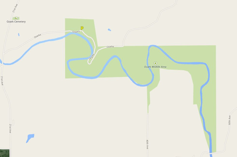
Take 6th Ave north out of Canton, turn right on 166st and then left on 21st Ave. Just after you cross the bridge over the Maquoketa river there is a small road alongside a corn field (Ozarks Rd). At the back side of the cornfield go through the gate. The crag is on the left hand side after the road starts to pull away from the river. Its hard to spot, the climbs are on top of a bluff.

Routes from Left to Right

5.7 5a 15 V+ 13 MVS 4b
 7
To Di For
Sport
5.11b 6c 23 VIII- 23 E3 5c
 3
Turn to Stone
Sport
5.10c 6b 20 VII 20 E2 5b
 7
Blue Skies
Sport
5.10a 6a 18 VI+ 18 E1 5a
 24
Bad to the Bone
Sport
5.11a 6c 22 VII+ 22 E3 5c
 27
Liberal Tendencies
Sport
5.11d 7a 24 VIII 25 E5 6a
 9
Caution When Flashing
Sport
V3 6A
 1
Viciouser
Boulder
5.11b 6c 23 VIII- 23 E3 5c
 16
Deer Crossing
Sport
5.12a 7a+ 25 VIII+ 25 E5 6a
 13
Golden Showers
Sport
5.11d 7a 24 VIII 25 E5 6a
 4
Today
Sport
5.12d 7c 28 IX 28 E6 6b
 10
Back in the Groove
Sport
5.12a 7a+ 25 VIII+ 25 E5 6a
 25
Gravity Amp
Sport
5.11c 6c+ 24 VIII- 24 E4 6a
 14
Happy Hooking
Sport
5.12 7b+ 27 VIII+ 26 E6 6b
 1
Scarlet Tanager
Sport
5.10b 6a+ 19 VII- 19 E2 5b
 13
Power Surge
Sport
5.10a 6a 18 VI+ 18 E1 5a
 4
Happy Toes
Sport
5.10a 6a 18 VI+ 18 E1 5a
 4
Bone Yard
Sport
5.10a 6a 18 VI+ 18 E1 5a
 3
Blastoid
Sport
5.7 5a 15 V+ 13 MVS 4b
 2
Sword in the Stone
Trad
5.10a 6a 18 VI+ 18 E1 5a
 7
Big Muddy
Sport
Route Name Location Star Rating Difficulty Date
To Di For
 7
5.7 5a 15 V+ 13 MVS 4b Sport
Turn to Stone
 3
5.11b 6c 23 VIII- 23 E3 5c Sport
Blue Skies
 7
5.10c 6b 20 VII 20 E2 5b Sport
Bad to the Bone
 24
5.10a 6a 18 VI+ 18 E1 5a Sport
Liberal Tendencies
 27
5.11a 6c 22 VII+ 22 E3 5c Sport
Caution When Flashing
 9
5.11d 7a 24 VIII 25 E5 6a Sport
Viciouser
 1
V3 6A Boulder
Deer Crossing
 16
5.11b 6c 23 VIII- 23 E3 5c Sport
Golden Showers
 13
5.12a 7a+ 25 VIII+ 25 E5 6a Sport
Today
 4
5.11d 7a 24 VIII 25 E5 6a Sport
Back in the Groove
 10
5.12d 7c 28 IX 28 E6 6b Sport
Gravity Amp
 25
5.12a 7a+ 25 VIII+ 25 E5 6a Sport
Happy Hooking
 14
5.11c 6c+ 24 VIII- 24 E4 6a Sport
Scarlet Tanager
 1
5.12 7b+ 27 VIII+ 26 E6 6b Sport
Power Surge
 13
5.10b 6a+ 19 VII- 19 E2 5b Sport
Happy Toes
 4
5.10a 6a 18 VI+ 18 E1 5a Sport
Bone Yard
 4
5.10a 6a 18 VI+ 18 E1 5a Sport
Blastoid
 3
5.10a 6a 18 VI+ 18 E1 5a Sport
Sword in the Stone
 2
5.7 5a 15 V+ 13 MVS 4b Trad
Big Muddy
 7
5.10a 6a 18 VI+ 18 E1 5a Sport

Photos [Hide ALL Photos]

From Left to Right. Yellow - Deer Crossing (5.11b). Green - Golden Showers (5.12a). Red - Today (5.11d). Blue - Back in the Groove (5.12d). Pink - Gravity Amp (5.12a).
[Hide Photo] From Left to Right. Yellow - Deer Crossing (5.11b). Green - Golden Showers (5.12a). Red - Today (5.11d). Blue - Back in the Groove (5.12d). Pink - Gravity Amp (5.12a).
From left to right: Power Surge, Happy Toes (traverse), Boneyard, Blastoid.
[Hide Photo] From left to right: Power Surge, Happy Toes (traverse), Boneyard, Blastoid.
Brand new sign at the base of Hoot Bluff. Behind this is the footpath uphill to the climbs.
[Hide Photo] Brand new sign at the base of Hoot Bluff. Behind this is the footpath uphill to the climbs.
Hoot Bluff screenshot
[Hide Photo] Hoot Bluff screenshot
Ozark Wildlife Area map
[Hide Photo] Ozark Wildlife Area map
Good side view going the other way (from liberal to gravity amp)
[Hide Photo] Good side view going the other way (from liberal to gravity amp)
good side view of hoot. Shows the steapness (this view is from power surge looking down toward deer crossing)
[Hide Photo] good side view of hoot. Shows the steapness (this view is from power surge looking down toward deer crossing)
This is the sign you'll see at the base of the bluff. Just hike up about 50 yards past this sign
[Hide Photo] This is the sign you'll see at the base of the bluff. Just hike up about 50 yards past this sign
The pockets on this rock are too much fun.
[Hide Photo] The pockets on this rock are too much fun.

Comments [Hide ALL Comments]

Michael Bartosek
Los Angeles
[Hide Comment] The road along side the cornfield is 187th street, it is clearly marked and the outcrops are on the left hand side about an 1/8th of a mile after the point where the road and the river come very close together, the road starts to pull away from the river again and you'll see an old sign that looks to be warning of the dangers of climbing and climb at own risk. Sep 6, 2010
Conor Raney
Pinedale, WY
[Hide Comment] Is this near the Canton, Iowa just off the interstate?? I lived in Larchwood/Rock Rapids, Iowa. Is this near there? West Iowa?? Nov 12, 2010
Langlois
NYC
[Hide Comment] No its in eastern Iowa. About 30 mins west of Dubuque Nov 13, 2010
JJ Schlick
Flagstaff, AZ
[Hide Comment] Had some good times at this mini crag back in the day. If only you could get this stone in the 100' range... If you are in this corner of Iowa, this is the place for a decent pump. Mar 7, 2013
Carl Pelletier
Jackson, WY
[Hide Comment] My wife and I stopped in after a recent visit to the Quad Cities. A nice way to break up the drive! We found some fun climbs.

We also found:

TICKS!!! I had three on me that night. Just a heads up. Apr 11, 2013
J Crawford
Lone Tree, CO
[Hide Comment] If coming from 21st, the road is closed and is now a corn field. There is a sign up on 187/ozarks(google maps has this road named Ozarks) that says Level C Maintenance Road, No Trespassing. Park here and walk the left edge of the corn field. Keep walking till you see the broken down gate and the Ozark Wildlife Area sign to the RIGHT(partial overgrown with vegetation), this will be at the end of the corn field. Keep walking(you'll pass a limestone block in the middle of the trail). Keep walking past the culvert(you probably won't see this unless you get off trail). Just keep walking until you see a brand new white metal sign RIGHT BY THE "ROAD" indicating a climbing area. Facing the sign walk to the limestone outcropping behind it and go RIGHT and follow the path of least resistance up to the second tier and the main climbing area will be to the left(almost directly above the sign but on the second tier of the bluff.) Good area but not worth it unless you climb 5.11 and up. Sep 23, 2018
Daniel Madison
Des Moines, IA
[Hide Comment] BRING A STICK CLIP. Some of the climbs have high or sketchy first bolts.

If you are parking right off of 21st, there is a level C maintenance road that has a locked gate. It is about a mile hike to the bluff on a strip of what I believe is public land between private properties. Follow this maintenance road to the climbing spot. The climbing area is very clearly marked with a large white sign. Scramble up to the RIGHT SIDE of the sign to get to the climbing spot. We didn't have any trouble with getting in but are unsure of what is private property and what isn't. If you decide to check this place out please be respectful of the private property so that we can minimize issues with climbing here. All of the routes are short but the climbing is solid. Climbs are only 5.10 and up (except for the 5.7 which I think is sandbagged) so be prepared.The climbing area itself is very nice so let's try to keep it that way. Definitely worth the trip if Pictures Rocks is closed. Apr 19, 2020