To save paper & ink, use the [Hide] controls next to photos and comments
so you only print what you need.
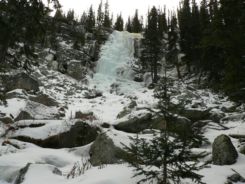
Rio Quemado Falls
New Mexico
> Santa Fe Area
> Truchas Peaks
Description
Often referred to as the best waterfall in New Mexico, the Rio Quemado Falls are a beautiful set of waterfalls high in the Sangre de Cristo mountains of New Mexico. For most of the year they offer a nice distraction to day hikers, backpackers and peak baggers destined for the high summits of the three Truchas Peaks. In winter, these ~60-foot waterfalls offer some enjoyable and very isolated ice climbing routes.
The ice is generally in from mid-December until March I'd guess. The easiest line follows a stair-stepped line up the center of the falls but harder lines with steeper ice seem likely on the left side while mixed options appear possible on the right side.
Getting There
Access to the Rio Quemado Falls is best done from the west via a very confusing maze of dirt roads from the town of Truchas, NM. Even having driven the roads many times, I still have trouble finding the trailhead in winter. It's best to go scope it in summer with a 4WD vehicle as the roads can be very rough. Also, the area here has a bad historical reputation for vehicle vandalism. That said, here's the best I can do: From the town of Truchas, drive east on the dirt road NM 75/NF639 for about 3 miles to where the road forks. Stay right. The general idea from here is to stay in the valley next to the creek but on the creek's north side. Numerous side roads will appear from time to time but stay on what appears to be the most traveled road. Your destination is the trailhead of 35° 59.80'N, 105° 41.43'W. A map might be helpful but probably not due to the crazy number of roads back there.
The trail is listed as Rio Quemado Trail 153. From the trailhead it's about 3 miles up to the falls. Skis with skins are a great idea in all but the leanest of snow conditions.
[Hide Photo] The falls on December 20, 2009. Compare this photo to the taken around the same time in 2005--the left side in 2009 really isn't forming but the right side is very thick. In…
[Hide Photo] The Rio Quemado Falls in December 2005.
[Hide Comment] January 17, 2010. Given the relatively dry past few weeks, we were easily able to drive to the confluence of the Rio de Truchas and the Rio de la Cebolla (about 5 miles up from Truchas), and then made it about another 2/3 mile up the Cebolla in 4wd before the chains became ineffective. A little meadow here provides one of the few turnarounds. From there, skin up ~6.5 miles w/ 2200 feet gain. Now THAT is an approach; uff da.
We met three local blokes coming down the Cebolla on ATVs as we were headed up, but when we got back to my vehicle at the end of the day, everything was OK.
Jan 19, 2010


 Continue with onX Maps
 Sign in with Facebook


![The falls on December 20, 2009. Compare this photo to the [[106096524]] taken around the same time in 2005--the left side in 2009 really isn't forming but the right side is very thick. In 2005, there was very little ice on the right side and the left was very fat.](https://mountainproject.com/assets/photos/climb/106634076_medium_1494127372.jpg?cache=1701316108)
Santa Fe
From there, skin up ~6.5 miles w/ 2200 feet gain. Now THAT is an approach; uff da.
We met three local blokes coming down the Cebolla on ATVs as we were headed up, but when we got back to my vehicle at the end of the day, everything was OK. Jan 19, 2010