Perla's Ridge and Environs Climbing
Use onX Backcountry to explore the terrain in 3D, view recent satellite imagery, and more. Now available in onX Backcountry Mobile apps! For more information see this post.
| GPS: |
40.56816, -111.75494 Google Map · Climbing Area Map |
| Page Views: | 15,497 total · 67/month |
| Shared By: | Colby Wayment on Jun 7, 2006 · Updates |
| Admins: | Perin Blanchard, GRK, David Crane |
 Access Issue: Gate Buttress Area Recreational Lease: Climbs on Church Buttress above vault remain closed
Details
Climbers Partner with LDS Church on Stewardship of Little Cottonwood Canyon Climbing
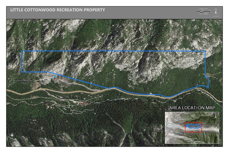
June 1st, 2017:The Salt Lake Climbers Alliance (SLCA), the Church of Jesus Christ of Latter-day Saints (LDS Church), and Access Fund announce the signing of an unprecedented lease for 140 acres in Little Cottonwood Canyon (LCC). The parcel, known as the Gate Buttress, is about one mile up LCC canyon and has been popular with generations of climbers because of its world-class granite.
The agreement secures legitimate access to approximately 588 routes and 138 boulder problems at the Gate Buttress for rock climbers, who will be active stewards of the property. The recreational lease is the result of several years of negotiations between LDS Church leaders and the local climbing community.
Access Note: The climbs on the Church Buttress above the vault as well as the Glen boulders that have been traditionally closed will remain closed.
Please help us steward this area and leave no trace.
Read More:
saltlakeclimbers.org/climbe…
Description

This area is located on the southern side of Little Cottonwood Canyon across from the Gate Buttress. Thus, it stays shaded in the summer. Unfortunately, as of now, there aren't many routes - or at least recorded ones that I know of. The listed routes in Ruckman's guidebook are also distanced from one another. Perhaps there is much potential for new route development - if so, make sure you post new routes here.
The rock type and quality varies, but where I went it was more akin to the Pentapitch area than the rock across the canyon.
The rock type and quality varies, but where I went it was more akin to the Pentapitch area than the rock across the canyon.
Getting There

The hike will be slightly different depending on which climb you go to, but the general approach seems the same. Also, it is fairly long (by LCC standards), but not too arduous.
To start park in the Gate Parking area. Walk roughly 50 yards East of the Gate Parking, cross the road and then cross the river via a large steal pipe supported by cables. Once you reach the dirt road, walk along the road/bike path back west until you reach a wooden bridge. But, instead of crossing the bridge, continue walking on a small foot path until you reach the drainage (talus field). Distance from the bridge to the drainage is roughly 200 yards. Along the foot path there are many boulders - I assume this is a bouldering area. Walk directly up the drainage until you reach the base of the wall. The approach from here will depend on what route you intend to do.
To start park in the Gate Parking area. Walk roughly 50 yards East of the Gate Parking, cross the road and then cross the river via a large steal pipe supported by cables. Once you reach the dirt road, walk along the road/bike path back west until you reach a wooden bridge. But, instead of crossing the bridge, continue walking on a small foot path until you reach the drainage (talus field). Distance from the bridge to the drainage is roughly 200 yards. Along the foot path there are many boulders - I assume this is a bouldering area. Walk directly up the drainage until you reach the base of the wall. The approach from here will depend on what route you intend to do.
Classic Climbing Routes at Perla's Ridge and Environs
Mountain Project's determination of the classic, most popular, highest rated climbing routes in this area.
Weather Averages
|
High
|
Low
|
|
Precip
|
Days w Precip
|
Prime Climbing Season
| J | F | M | A | M | J | J | A | S | O | N | D |
| J | F | M | A | M | J | J | A | S | O | N | D |
Photos
All Photos Within Perla's Ridge and Environs
Most Popular · Newest · RandomMore About Perla's Ridge and Environs
Printer-FriendlyWhat's New
Guidebooks (10)

 Continue with onX Maps
 Sign in with Facebook


0 Comments