Mountain Project Logo
To save paper & ink, use the [Hide] controls next to photos and comments so you only print what you need.

The Maiden

Colorado > Boulder > Flatirons > South
Warning Access Issue: 2024 Crag Closures & Temporary Trail and Raptor Closures DetailsDrop down

Description

The Flatirons present a bewildering maze of rock above and to the south of Boulder. Many famous rocks and routes grace this area. The First and Third Flatirons reign over downtown Boulder. A couple miles to the south, the Slab's squat mass dominates. Just north of Eldorado Canyon, the Devil's Thumb dominates the skyline. However, the true ruler of this area is the Maiden, unique among the Flatirons.

Viewed from the east, this crag is a nearly invisible blade of rock tucked in between other seemingly more substantial flatirons. However, while driving to Eldorado Canyon, the careful eye will discern the true nature of the Maiden. From the south, the Maiden is shaped like a dolphin leaping up the wave of the foothills. Climbers will immediately notice the imposing overhang on its west side as well as the vertical nature of its east ridge. No other summit in the Boulder area appears more improbable.

Up close, the effect is amplified rather than diminished. The east ridge terminates in the trees with a disturbingly narrow girth. The north and south faces are sheer, and the low angle west ridge terminates at a narrow vertical west face that leads to the amazing west overhang and the summit. Like Wyoming's Devil's Tower and Utah's Ancient Art, the Maiden appears to be of other-worldly construction.

One of the highlights of any ascent of the Maiden is actually the descent. The rappel off the summit and over the West overhang is simply unbelievable. After completing this rappel for the first time, I couldn't believe that kind of excitement was both free and legal.

The Maiden sports routes of all levels of difficulty. The easiest route is the convoluted North Face at 5.6. Next up is the South Face at 5.8. The narrow East Ridge is climbed with a couple pitches of 5.10, and the fearsome West Overhang can be breached with a pitch of 5.11. Other routes of note are South Crack (5.11) and Cunning Stunt (5.11-).

Getting There

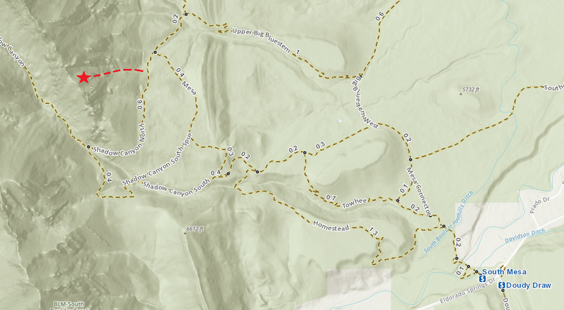
The Maiden is a bit of a hike from the trailhead which tends to keep the crowds to a minimum. Begin at the southern end of the Mesa Trail, and hike until directly below the Maiden, which will be hidden in the trees. When hiking the Mesa Trail, looking for the left turn onto the Shadow Canyon Trail, take the *second* intersection of the Shadow Canyon trail with the Mesa trail, NOT the first. The trail is a loop, and the Maiden is above the section where Shadow Canyon intersects Mesa the second time. Per D Hammond: accessing this from South Mesa Trailhead, this will be the third intersection with Mesa and a Shadow Canyon derivative (the first is with Shadow Canyon South Trail; the second is with Shadow Canyon South Spur; the *third* and the one you want is with Shadow Canyon North Trail. The Maiden is above the section where Shadow Canyon North intersects Mesa. The Maiden is intermittently visible through the trees to the west as one approaches the correct intersection. It is not visible at the first intersection.

The Shadow Canyon trail connects to the Mesa Trail at an old water trough. The water trough is on the east side of the trail at a bend in the trail and is obvious. Turn left on the Shadow Canyon trail and walk up this for a couple minutes (don't go too far). Begin looking to the right through the trees. When hiking up the Shadow Canyon trail briefly, there is a cairn at the point where one should begin thinking about leaving the trail to the right. This cairn will get one to the south face of the Maiden. Interestingly, it won't get one there via the easiest route. A better trail exists just a bit further up Shadow Canyon than the first cairn. When talus is visible, follow a faint path through the woods (watch for poison ivy) to the talus. You should be near an old, shallow quarry pit. A wall will be visible up the unstable talus slope, which marks an old stretch of access road for the quarry. The talus is bordered on the right by a strip of trees. There is a faint path up through the strip of trees - follow that, or scramble directly to the road. The road goes through the strip of trees - at this point head up a path that follows the strip of trees. Eventually, this steep path will deposit you at the base of the East Ridge. Allow a couple hours for the approach and plan on maybe getting lost the first time.

Or per Andy Westmeyer: from South Mesa Trail, follow until you hit the North Shadow Canyon Trail (not the South).  Make a left at the North Shadow Canyon Trail, and an obvious cairn will be on the right as is a climber's trail that you want.  Follow a faint path through the woods (watch for poison ivy) to an old shallow quarry pit. You should be near an old, shallow quarry pit.  There is a faint path up through the strip of trees - follow that, or scramble directly to the road. The road goes through the strip of trees - at this point head up a path that follows the strip of trees. Eventually, this steep path will deposit you at the base of the East Ridge. Allow a couple hours for the approach, and plan on maybe getting lost the first time.

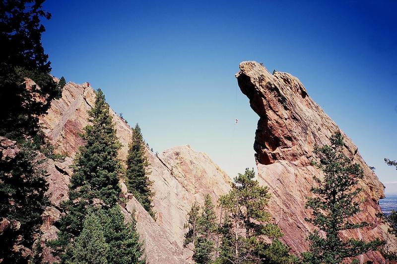
To descend from the summit, make a double rope rappel (or likely a 70m rope) from bolts with chains (previously slings) down over the West Overhang . This will deposit you at the Crow's Nest. From there, either reverse the first half of the North Face route, or do another double rope rappel from the bolt down the south face.

Google satellite  map: https://goo.gl/maps/k2xhVgxGUatL1jBEA.

Map

.

Routes from Left to Right

5.10d 6b+ 21 VII+ 21 E3 5b X
 13
Gates of Galas
Trad, TR
5.11c 6c+ 24 VIII- 24 E4 6a
 50
The Gates of Delirium
Sport
5.13c/d 8b 31 X 31 E8 7a
 3
Queen-line
Trad 3 pitches
5.12a 7a+ 25 VIII+ 25 E5 6a R
 4
Kor-Dalke Route
Trad 5 pitches
5.13b 8a 29 IX+ 30 E7 6c
 42
Hasta La Hueco
Sport 3 pitches
5.8 5b 16 VI- 15 HVS 4c R
 40
South Face
Trad 4 pitches
5.9+ 5c 17 VI 17 E1 5a X
 1
Eye Of the Storm
Trad 2 pitches
5.11b 6c 23 VIII- 23 E3 5c R
 2
Belladonna
Trad
5.11b 6c 23 VIII- 23 E3 5c
 1
The Southern Seas
TR
5.11- 6c 22 VIII- 22 E3 5c
 19
Heart of the Sunrise
Sport 2 pitches
5.11b 6c 23 VIII- 23 E3 5c
 52
South Crack
Trad
5.10c 6b 20 VII 20 E2 5b
 145
East Ridge
Trad 5 pitches
5.11b/c 6c+ 23 VIII- 24 E4 6a
 13
Dream Street Rose
Trad 2 pitches
5.12b 7b 26 VIII+ 26 E5 6b
 22
North Side of the Sky
Sport 2 pitches
5.10d 6b+ 21 VII+ 21 E3 5b R
 10
Cunning Stunt
Trad
5.9 5c 17 VI 17 HVS 5a R
 4
Direct North Face
Trad 2 pitches
5.6 4c 14 V 12 S 4b R
 244
North Face
Trad 5 pitches
5.11b/c 6c+ 23 VIII- 24 E4 6a
 58
West Overhang
Trad 2 pitches
5.12c 7b+ 27 IX- 27 E6 6b
 16
Maiden Voyage
Sport
Route Name Location Star Rating Difficulty Date
Gates of Galas
 13
5.10d 6b+ 21 VII+ 21 E3 5b X Trad, TR
The Gates of Delirium
 50
5.11c 6c+ 24 VIII- 24 E4 6a Sport
Queen-line
 3
5.13c/d 8b 31 X 31 E8 7a Trad 3 pitches
Kor-Dalke Route
 4
5.12a 7a+ 25 VIII+ 25 E5 6a R Trad 5 pitches
Hasta La Hueco
 42
5.13b 8a 29 IX+ 30 E7 6c Sport 3 pitches
South Face
 40
5.8 5b 16 VI- 15 HVS 4c R Trad 4 pitches
Eye Of the Storm
 1
5.9+ 5c 17 VI 17 E1 5a X Trad 2 pitches
Belladonna
 2
5.11b 6c 23 VIII- 23 E3 5c R Trad
The Southern Seas
 1
5.11b 6c 23 VIII- 23 E3 5c TR
Heart of the Sunrise
 19
5.11- 6c 22 VIII- 22 E3 5c Sport 2 pitches
South Crack
 52
5.11b 6c 23 VIII- 23 E3 5c Trad
East Ridge
 145
5.10c 6b 20 VII 20 E2 5b Trad 5 pitches
Dream Street Rose
 13
5.11b/c 6c+ 23 VIII- 24 E4 6a Trad 2 pitches
North Side of the Sky
 22
5.12b 7b 26 VIII+ 26 E5 6b Sport 2 pitches
Cunning Stunt
 10
5.10d 6b+ 21 VII+ 21 E3 5b R Trad
Direct North Face
 4
5.9 5c 17 VI 17 HVS 5a R Trad 2 pitches
North Face
 244
5.6 4c 14 V 12 S 4b R Trad 5 pitches
West Overhang
 58
5.11b/c 6c+ 23 VIII- 24 E4 6a Trad 2 pitches
Maiden Voyage
 16
5.12c 7b+ 27 IX- 27 E6 6b Sport

Photos [Hide ALL Photos]

The Maiden with some morning fog burning off.
[Hide Photo] The Maiden with some morning fog burning off.
The Maiden's West face and free rap as seen from Jamcrack Spire, to the South. Photo by T. Bubb, 09/06.
[Hide Photo] The Maiden's West face and free rap as seen from Jamcrack Spire, to the South. Photo by T. Bubb, 09/06.
Sam Dorsey rapping into the void.
[Hide Photo] Sam Dorsey rapping into the void.
The Maiden.
[Hide Photo] The Maiden.
A photo by Derek Wright of Jake DiSanto rapping off the Maiden after doing the "Walton Traverse".
[Hide Photo] A photo by Derek Wright of Jake DiSanto rapping off the Maiden after doing the "Walton Traverse".
The rap.
[Hide Photo] The rap.
Staring up at the west face.
[Hide Photo] Staring up at the west face.
Looking down the Maiden rap.
[Hide Photo] Looking down the Maiden rap.
Here is all you need to know about the approach. The dotted line starts at about 39.950261, -105.283469 (https://goo.gl/maps/k2xhVgxGUatL1jBEA). Get there, head west, and you'll find the climber's trail.
[Hide Photo] Here is all you need to know about the approach. The dotted line starts at about 39.950261, -105.283469 (https://goo.gl/maps/k2xhVgxGUatL1jBEA). Get there, head west, and you'll find the climber's…
West Face from the top of P1.
[Hide Photo] West Face from the top of P1.
Rapping down after doing The East Ridge.
[Hide Photo] Rapping down after doing The East Ridge.
Approach beta: from the water trough go left on the Shadow Canyon Connector Trail. Walk a little farther than you think. Turn off where the old quarry road practically touches the trail.  Follow the quarry road back north till a cairned trail directly under The Maiden. If you are in poison ivy or loose talus, you went the wrong way....
[Hide Photo] Approach beta: from the water trough go left on the Shadow Canyon Connector Trail. Walk a little farther than you think. Turn off where the old quarry road practically touches the trail. Follow th…

Comments [Hide ALL Comments]

Michael Komarnitsky
Seattle, WA
[Hide Comment] Mike's comment that it is "a bit of a hike" is no understatment. Perhaps since we thought it was just a flatirons jaunt and thus maybe a 30 minute approach.... allow 1 1/2 - 2 hours for the approach, especially the first time - we got lost.

When you get to the talus (30 yards off the trail) - head DUE NORTH - don't get sucked up and into the talus - you'll find the trail which expands to a road, then probably 300 yards along see a faint trail heading straight up. Damn, that was a long hike. Aug 27, 2001
[Hide Comment] As stated by Mike, this is the mother of all rappels.

We were able to do both rappels (independently) with a 60M rope. Grant it, there was not a lot of rope left, but it was comfortable enough. Also, there was no wind the day we did this.

Now, I have heard horror stories of people being swung out by the wind away from the crow's nest and having to time the descent with the variations in the wind... Needless to say this would be even more horrific if all you had left were 10 feet of rope as you swung over 100ft of air...

So, make sure your rope was cut to the appropriate length at the factory and tie them ends. Enjoy the rush... Lot's of nervous giggling usually follows the first rappel... Oct 1, 2001
[Hide Comment] Who needs a GPS when you can do it the old fashioned way? Here is the info you've been waiting for: As described above, the Shadow Canyon Trail intersects the Mesa Trail at an obvious water trough. From the Mesa Trail, take between 192 (for taller folks) and 233 (for shorter folks) steps up the Shadow Canyon Trail. Then, head right through the trees and poison ivy to the quarry. Follow my directions from there.

I didn't time us on the way in, but the hike out took exactly 1 hour (very casual pace) from the bottom of the Maiden to the South Mesa trailhead. Of course, it's mostly all mellow downhill. Oct 22, 2001
[Hide Comment] Myke is actually describing a slightly different approach in his comment. It sounds to me like he is saying to continue further up the Shadow Canyon Trail, then head right and walk directly to the quarry road. This way may indeed be better, but it probably doesn't matter too much. Heck, the first time I tried to get there I ended up thrashing around below the Fatiron, so any way is better than that.

My point is that my step count probably won't match his GPS coordinates. Oct 24, 2001
[Hide Comment] Mike's approach description is very good. It took us 1 hour 5 minutes following his beta, moderate pace, light rack, 2 light ropes. Nov 5, 2001
[Hide Comment] You can do the rappel from the summit to the ground as a single rappel if you have two 60 meter ropes. You end up dropping off the end of your rope about two feet above the ground! Nov 19, 2001
[Hide Comment] Be careful about the weather when you attempt this climb.

The weather was great before the last pitch yesterday on the North Ridge. It got very windy and made the rappeller feel as if being dropped from a helicopter. It was hard to hit the crow's nest and even harder to pull the ropes.

We couldn't pull them and had to rap from the summit to the bottom and get the ropes this morning when the wind died down. Feb 11, 2002
Ivan Rezucha
Fort Collins, CO
[Hide Comment] Another approach (as showed to me by Josh Janes):This is a nice alternative, but may not save any time. Go up this way and down one of the other ways to do a loop.Immediately after starting up the Mesa Trail, turn left on the Towhee Trail. Follow this good trail steadily up until it joins the Shadow Canyon trail (a good dirt road). Turn left on the Shadow Canyon trail, pass below the Matron, and pass some structures, until you are at the mouth of Shadow Canyon (small stream crossing here). Turn right on a small trail (with sign) that connects to the Mesa Trail. This is the same "Shadow Canyon" trail mentioned above. Gently down (not too much elevation loss), until you come to the flat quarry "road" mentioned by Myke above. Aug 6, 2003
Cody Munger
Carson City, NV
[Hide Comment] Make sure you take the third Shadow Canyon turnoff from the Mesa Trail. I got confused because I hit 2 turnoffs to Shadow Canyon before giving up because I thought maybe the water trough was gone (it won't be, quite permanent).

Also, it's in your best interest go up on the south side of the Maiden. The north side is very difficult comparatively. Filled with huge boulders, downed trees, and overgrown with ferns and raspberrys. Oct 31, 2005
[Hide Comment] Just an FYI. I climbed on the Maiden yesterday and was able to do two single rope (60M) raps from the bolts at the notch at the top of crux pitch on the South Face. 1st rap is about 40-50ft with a swing over to the 2 bolt anchor. 2nd rap just gets you to the ground with rope stretch (110 ft.) Nov 7, 2006
Kevin Dahlstrom
Boulder, CO
[Hide Comment] The approach isn't bad and would be considered an easy to moderate approach at other destinations (e.g. Red Rocks). We followed the instructions above and reached the base of the East Ridge in 65 minutes at a brisk walking pace. Just follow the cairns and make sure you locate the faint path through the trees to the right of the talus. Jun 26, 2011
[Hide Comment] Mike Alkaitis and I just backed up the single old CMC eyebolt, at the Crow's Nest rappel, with a new bolt/chain anchor. Now you don't have to worry about the fifty year old ??? eyebolt failing. The face just below this rappel is an excellent top rope and is probably .11+ or .12a - if you avoid escaping left into "Gates of Galas" crack system. Definitely worth checking out. Curiously, there were combat-style boots just sitting neatly at the base of this rappel, with nobody else around. It kind of creeped Mike and I out. Mar 7, 2014
Eric Klammer
Eagle, CO
[Hide Comment] ^^^
Many thanks for the hardware update. Was just up there today and it looks great! Definitely glad not to be rapping off of that single bolt anymore, no matter how large it is....

In regards to the combat boots, they have been up there for a couple of months now. Saw them a while ago and placed them under the large boulder by the rap where you most likely found them. There was a guidebook with the boots as well as a bail anchor made up of brand new gear on the North face. Curious (and kind of creepy) indeed! Apr 5, 2014
Adam Brink
trying to get to Sardinia
[Hide Comment] What are the 2 wild looking sport climbs that break off right from part way up the first pitch of the West Overhang and the top of the first pitch of the West Overhang? Amazing looking lines! Aug 31, 2014
[Hide Comment] Tried to get on this today. The map posted at the first Shadow Canyon traihhead makes it look like The Maiden is now within the raptor closure area (as opposed to the current MP seasonal closure warnings). Unless someone knows for sure that it is outside of the area, I wouldn't get on it until the closures are removed. Apr 12, 2015
Jonathan S
Golden, CO
[Hide Comment] Regarding raptor closures, from here bouldercolorado.gov/osmp/cl…: "Shadow Canyon and the Matron [are closed] (the Maiden will remain open and accessible from the east; Shadow Canyon Trail will remain open)". Looking at the closure map, you have to zoom in, but you can see the boundary skirts the Maiden. Apr 23, 2015
[Hide Comment] There is an application for fixed hardware for a new climb on the south side of the Maiden. The climb is directly below the last rappel of the standard rappel route from the summit. Details can be found at flatironsclimbing.org. The public meeting and vote will be held Thursday February 1 at 6:30 p.m. at The Spot Gym, Boulder, Colorado. Please feel free to post comments on the FCC page, and also come to the public meeting! Dec 31, 2017
Mark Roth
Boulder
[Hide Comment] There is a new route application submitted for the January 2019 cycle of the FCC's Fixed Hardware Review Committee application process. The proposed route is on the South Face to the left of South Crack.

Please visit the FCC site:
flatironsclimbing.org/curre…
to review the application and leave any comments you have. The public vote and meeting is set for 6:30 pm on January 29th at The Spot in Boulder, Colorado. Jan 2, 2019
Matt G
Boulder, CO
[Hide Comment] Would recommend heavily trimming the approach description; a lot of hard-to-follow info made even more confusing by the many similarly-named sections of Mesa and Shadow Canyon trails (and spurs). Just get here and head west, it's that easy: goo.gl/maps/k2xhVgxGUatL1jBEA.

I also added a pic: mountainproject.com/photo/1…- Oct 20, 2019
Mark Roth
Boulder
[Hide Comment] There is a new route application submitted for the August 2021 cycle of the FCC's Fixed Hardware Review Committee application process. The proposed route is a two pitch route on the North Face.

Please visit the FCC website: flatironsclimbing.org/curre…

to review the application and leave any comments and find details about the public meeting. Aug 23, 2021
Mark Roth
Boulder
[Hide Comment] The Flatirons Climbing Council Fixed Hardware Review Committee has received an application for a new bolted route on the South face of The Maiden. Please visit FlatironsClimbing.org to make comments.

The public meeting and vote will be held Wednesday, June 1st, upstairs at the BRC at 6:30. May 4, 2022
Stephen Becker
Boulder, CO
[Hide Comment] Simplified approach directions (perhaps not the very fastest, but good enough): get to the intersection with the Shadow Canyon Trail (we preferred approaching via Shanahan, since it's more shady and has easier parking, though perhaps a little slower). Go up the cutoff trail farther than you think until you hit the old stone road. Take this road North a good ways until you're back in the fall line under the Maiden. In the little shaded ravine, there's a clear climber's trail. Take this. Jul 3, 2023
Mark Roth
Boulder
[Hide Comment] The Flatirons Climbing Council has received an application for a new bolted route on this formation.

Please visit the FCC web site to see, and comment on, this and the other proposals this cycle: flatironsclimbing.org.

The public meeting to vote on these applications will be held at the BRC on June 7th at 6:30 pm. May 20, 2024
[Hide Comment] Climbed Maiden several times in late 1960s. My recollection is that we approached from above (there was a trail or old road near the ridge crest, I think). We came down slabs and low difficulty pitches to the Crow's Nest (we didn't bother roping!). We really only considered that the climb "began" at the Crow's Nest. There were no bolts except for the rappel anchor. No protection for the leader! I was comfortable at 5.3, and North Face was then rated 5.4, which was a real push for me. The traverse across the face was done as a single pitch. The last 20' or so of the traverse up to the belay point where it turns vertical was the crux. Most climbs were under the auspices of the CSU Mountain Club and a were typically 5-8 in group size. Gently twisting on the rappel rope and watching the panorama including NCAR sweep by was a real rush! Mar 21, 2025