Colorado
> Boulder
> Eldorado Mountain
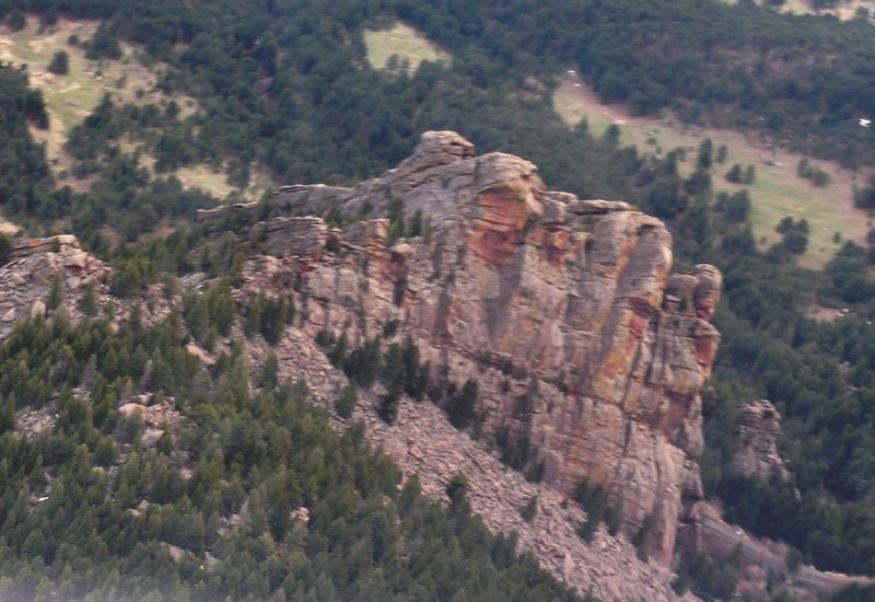
The rock at Mickey is clandestine in a sense. It sees very little traffic since the approach is so long, but the area gives an almost "mystical" aura, to quote my friend Dave Simmons.
There are some great routes here up to 4 pitches long. The greatest majority of the routes are traditionally protected, although the most difficulty are mostly bolt protected. The grading of the routes is starkly grounded. Approaches tend to have poison ivy in way more places than you would like.
The shortened season and the longer approach make the climbing here that much more precious.
There is now legal approaches, thanks to the hard efforts of the climbing community.
Complicated! Print this out!
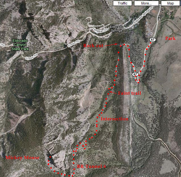
To reach Mickey Mouse Wall, take the road to Eldo and turn left on County Road 67 (paved) right before the town. Go about 300 yards to a locked gate. Park here.
Hike up the same road to the south, then to the north, then back south. At 1/2 mile there is another dirt road to the left. Pass this to the right, turn back to the north and pass through a major rock cut. Here the road turns south; when it turns back north, you will be in a small drainage filled with trees.
Hike up this drainage for ~200 yards up a very indistinct trail. Find an old road and follow it for a few hundred yards until it intersects a larger dirt road. Find a good trail at this intersection and hike up through open forest and a grassy meadow.
Crest a small ridge and you will find a fork. The left goes downhill and to the southeast. Take the right fork uphill to the southwest. Follow this trail to the railroad tracks.
At the tracks, turn left and go AROUND tunnel 6 (there will be a "T6" sign). The old approach had you listen for trains first, be careful, and go fast!
Eds. there is also a trail that goes around Tunnel 6. It gains 150-200 vertical feet, but it is legal.The wall is immediately on the other side of the tunnel. There is a very poor trail right under the wall, and big talus (preferable) a little to the left. Hike up to your route.
Per
Byron Murray:
New hiking trails in the area therefore updating directions:
To reach Mickey Mouse Wall, take the road to Eldo and turn left on County Road 67 (paved) right before the town. Go about 300 yards to a locked gate. Park here.
Hike up the maintained gravel road, avoiding a left after about 0.5 mile, and continue through a rock cut. Continue hiking up the road aka "Fowler Trail" avoiding a few single track trails heading off to the right. Continue hiking up the road avoiding roads that go off to the right up to the Conda Quarry. At an intersection with a road and a gate on the right continue straight onto a double track for about 100 feet and then take a right onto a single track.
Continue on the single track avoiding a left single track aka "Goshawk Ridge Trail" all the way to the train tracks.
At the tracks, many climbers USED to turn left and go through tunnel 6 (there will be a "T6" sign). They USED HAVE TO listen for trains first, be careful, and go fast!
MUCH BETTER NOW, when you arrive at the tracks, turn left and walk along the east side of the tracks towards the tunnel (tunnel 6). About 20 feet before the tunnel, take a faint trail up the dirt berm on the left.
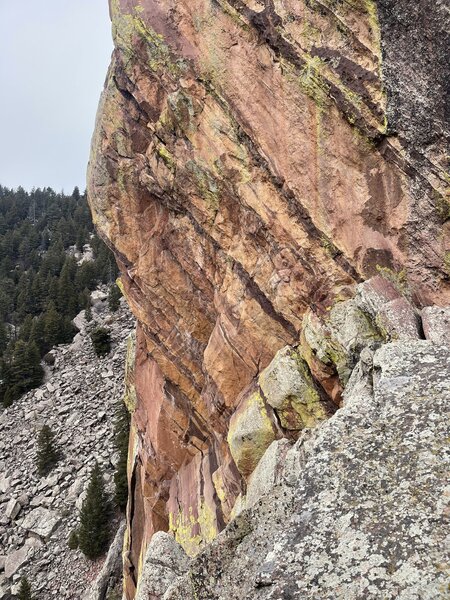
The wall is immediately on the other side of the tunnel.
Please DO NOT go through the tunnel. You will climb approximately 200 feet contouring uphill to skirt around the east side of the tunnel, generally paralleling the direction of the tracks. Eventually you will crest the ridge and start descending, continuing to contour around the ridge until you arrive back at the tracks. Promptly cross the tracks and continue towards the wall on the southwest side of the tracks. There is a very poor trail right under the wall, and big talus (preferable) a little to the left. Hike up to your route.
Per
Tank Evans: there is a well worn trail that bypasses the tunnel 6 that is MUCH preferred than the old approach through the tunnel. The trail over adds maybe 5 minutes to the approach and is the RECOMMENDED APPROACH.

 Access Issue: Private Property issues
Details
 Access Issue: Closed for raptor nesting from February 1 through July 31 - each year
Details


Coal Creek Canyon,Colorado
Wheat Ridge, CO
From the amount of slings, ropes, and shite that we pulled down it is safe to guess that this has not been done for a while. It would make much more sense to put in a couple of rap bolts because they are certainly less noticable and safer than the clump of webbing we replaced. I guess that is the way it has to be since the Flatiron Bolting Ban ... they should change it to create a committee like the rest of Eldo.
casey bernal Jan 8, 2003
Boulder, CO
Golden, CO
Louisville, Co
Oh [yeah], no matter how you go to Mickey [Mouse], you have to get close to the tracks. [Locomotive] Breath is right on the tracks... Nov 18, 2003
Fort Collins, CO
But, that said, how great to climb on such wonderful rock on a sunny Sunday with no crowds! Aug 30, 2004
It is owned by Boulder. Under the proposed new OSMP Visitor Plan, a number of local crags will be shut down forever. Mickey Mouse is the largest. Others include Continental Crag (up above Peanuts), Upper Peanuts Wall, The Sacred Cliffs.
Boulder Open Space and Mountain Parks have presented this proposal to Boulder City Council. Boulder City Council will discuss this on Tuesday 14th December.
Please phone or email the Boulder City Council Members (who love to hear from people about issues like this) that this is unacceptable.
Show up this Tuesday, Dec 14th at 6:00pm at Council Chambers (Broadway and Canyon). Bring a friend, or two, or eight. Let's pack the room.
More details are at:
keep-open-space-open.org/
Details of the folks who will decide on this issue are at:
ci.boulder.co.us/cmo/cityco…
They are:
Robin Bohannan 303-524-9067 11/18/03 11/072814 15th Street; 80304 720-938-5215bohannanr@ci.boulder.co.usbohannan@indra.comThomas Eldridge 303-449-8419 303-443-3336 02/18/97 11/051301 Canyon Blvd. #406; 80302 303-443-3336 (fax)eldridget@ci.boulder.co.usCrystal Gray 303-449-9680 11/18/03 11/071709 Spruce Street; 80302grayc@ci.boulder.co.uscrystal_boulder@hotmail.comShaun McGrath 720-304-2165 11/18/03 11/05225 29th Street; 80305mcgraths@ci.boulder.co.uss.l.mcgrath@att.netGordon Riggle 303-530-7181 11/18/97 11/055225 Pinehurst Dr.; 80301riggleg@ci.boulder.co.usMark Ruzzin 303-417-9798 11/20/01 11/073135 5th St.; 80304ruzzinm@ci.boulder.co.usmruzin@swenergy.orgAndy Schultheiss 303-440-3321 11/18/03 11/053370 25th Street; 80304schultheissa@ci.boulder.co.usJack Stoakes 303-449-3374 303-449-3374 11/18/03 11/072727 Folsom St., #110; 80304stoakesj@ci.boulder.co.usWilliam R. Toor 303-544-0104 11/18/97 11/053032 10th St.; 80304toorw@ci.boulder.co.us Email, phone or write. Do all three. Dec 12, 2004
Boulder
From the book:
"From Hwy 170, turn left at the paved road and continue up to a locked gate. Hike on the road..."
our version, continued:
...then make a bad decision, bearing left on said road instead of right, necessitating a bushwhack (read: "hacking through bushes") up over the ridge. Trend south, slightly descending into the valley, and attempt to take a faint game trail which ends up going through a fence that would take you onto posted private property. Alternatively, continue steep bushwhack up to railroad tracks, negotiating veritable lakes of poison ivy and forests of young willows along the way, finally arriving 75 feet above the train bridge. Descend the 75 feet and cross the tracks. Negotiate more poison ivy and climb the loose talus and boulder field. It is now 10:30 a.m. 'Perversion' is still a ways up. Do not be daunted. It's worth the effort. Should've taken a right at the fork in the road." Aug 18, 2006
Arvada
Longmont, CO
Longmont, CO
Boulder, CO
To reach Mickey Mouse Wall, take the road to Eldo and turn left on County Road 67 (paved) right before the town. Go about 300 yards to a locked gate. Park here.
Hike up the maintained gravel road, avoiding a left after about 0.5 mile, and continue through a rock cut. Continue hiking up the road aka "Fowler Trail" avoiding a few single track trails heading off to the right. Continue hiking up the road avoiding roads that go off to the right up to the Conda Quarry. At an intersection with a road and a gate on the right continue straight onto a double track for about 100 feet and then take a right onto a single track. Continue on the single track avoiding a left single track aka "Goshawk Ridge Trail" all the way to the train tracks.
At the tracks, turn left and go through tunnel 6 (there will be a "T6" sign). Listen for trains first, be careful, and go fast!
The wall is immediately on the other side of the tunnel. There is a very poor trail right under the wall, and big talus (preferable) a little to the left. Hike up to your route. Oct 18, 2008
Boulder, CO
Fort Collins CO
Boulder, CO
According to the description posted on MP:
"At an intersection with a road and a gate on the right continue straight onto a double track for about 100 feet and then take a right onto a single track."
We hiked up that way and at the single track, there is a sign that says "climber access trail only, dead end"
Further up the trail, just before you get to the railroad tracks, there is another large sign saying "Raptor Nesting Closure. Area behind this sign is closed between February 1 and July 31."
We hiked past that and then did not go through the tunnel, but rather used the trail around it, thinking it would be safer. When we got out on the other side of the tunnel, we were about 15 feet from the railroad tracks and there was another raptor closure sign. At this point, a rail road worker saw us and started yelling, being quite rude, and threatening to call the railroad police.
We had not yet stepped on the railroad tracks (there was a train stopped through the tunnel). We had just passed a raptor closure sign, and I'm not sure what laws apply. The sign, by saying the area is closed between Feb-July, implies the area to be open the rest of the year.
So, what is the story? Can the railroad really have you arrested? I can maybe see it is illegal to cross the tracks or run through the tunnel (we went around it), but this rude guy was being a jerk and telling me all the area around was railroad property, including the hillside we just came up which had several Boulder Open Space signs on it, so I think he was just being full of shit and threatening us.... Sep 2, 2010
leeds, ut
Amended instructions:
Get onto Fowler trail^. Take Fowler to the Goshawk Ridge trail intersection. Continue onto Goshawk. Just past where it turns from gravel road to dirt singletrack, go right on the signed climber's trail. Take the trail to the railroad tracks. Select a way to get past the railroad tunnel. After the tunnel, look on the right side of the tracks for a faint trail that dips down briefly then skirts the base of Mickey Mouse Wall.
^ Options to access Fowler: Road 67, one of the Eldo town cut-offs, or from behind the Bastille. The Bastille way is the most straightforward if you're coming from the town of Eldo. Oct 24, 2012
Denver, CO
google.com/maps/d/edit?mid=… Apr 23, 2015
Curry village, Yose
We saw an Amtrak train around 9am. From that time until around 530-6pm, we saw one other train. Sometime between 530-6pm, as we were descending from the crag down to the tracks, a southbound coal train appeared out of tunnel six and cleared the tunnel maybe three minutes before we started walking the tracks, northbound into tunnel six. We figured there would not be another train for the foreseeable future, so we walked the tunnel with less trepidation/urgency than usual. (I've been in one of the other tunnels when a train appeared.) Less than five minutes after we exited the tunnel a southbound Amtrak entered the tunnel, moving fairly quickly and disturbingly quietly. Oct 17, 2017
Going through the tunnel jeopardizes both the life of you and your party as well as continued access to the fantastic climbing that Mickey Mouse and Industrial Wall have to offer. I personally have been caught in the tunnel by the Amtrak years ago and know of countless other parties with the same experience. Listening to the tacks WILL NOT WORK for the Amtrak, Its only a matter of time...
Admins, PLEASE UPDATE THE APPROACH DESCRIPTION! This has not been the recommended approach for at least 5-6 years. Nov 12, 2018
Westminster
Boulder
Denver, CO
Me and my climbing partner despite reading NOT to go through the tunnel, got to the tunnel (first time up to this wall) and decided to quickly jog through (and take the "lazy way") as it was dead silent. Shortly after, on our way up to the base of the wall a railroad truck cruised through (slowly could hear him coming), and at the time, my biggest fear was of a giant fine for being in the tunnel if one of those guys caught you.
Throughout the day a couple other smaller rail vehicles passed, but then we hadn't heard anything for a few hours, it was closer to evening as we walked off. Again, all was quiet, decided to go through the tunnel. After getting through, within 1-2 minutes of getting through, a passenger train (I think this may be the one that goes up to Winter Park) FLEW by, could barely hear it coming, was HAULING ass, and would have 100% SMOKED anyone in the tunnel (also there's no way you would out run it by the time you heard it if you were in the middle of the tunnel). Not to mention there are some spots that are narrower than others in the tunnel, and I doubt there'd be enough room to "get skinny".... Needless to say, will not be going through tunnel again...and for sure would say an extra 5-10mins of hiking after you've slogged that far is worth not getting hit by a train. Aug 27, 2021
Colorado
Boulder, CO
- Green Dihedral was dry.
- Perversion was wet and snowy.
- the approach was snowy and very slippery, microspikes recommended.
- climbing was comfy in the sun (11am-2:30pm only). Jan 23, 2022
From CO Highway 93, turn west onto CO Highway 170 (gas station) heading towards Eldorado Canyon. As you near the canyon proper, but before the town of Eldorado Springs, turn south onto CO Hwy 67 as if going to the Eldorado Mountain yoga ashram. Drive south on CO Hwy 67, and park near the gate that is typically locked. From the locked gate on CO Hwy 67, walk southward on what is now the Fowler Trail, and follow it as it passes through a few switchbacks. After about half a mile, the road forks. Take the right-hand fork (heading generally north). The trail continues to gain elevation and passes through a narrow and distinct rocky roadcut. Continue on as it works through more switchbacks. After roughly 1 mile, you will see the Fowler Trail intersects with the Goshawk Trail. Follow the Goshawk Trail. From the intersection, continue on the Goshawk Trail for approximately 1 more mile. Look for a posted climber access trail on the right. Turn right on the climber access trail (a small footpath, but it is easily identifiable). The trail goats its way up a steep meadows and wooded sections and eventually deposits you onto the railroad tracks after about ½ mile. Feel free to vomit here. Once at the tracks, turn south, passing the tunnel on a legal trail just on the left side of the tunnel. The tunnel avoiding trail follows a short, steep trail that passes over the shoulder immediately on the east side of the tunnel. Once on the south side of the tunnel, cross the tracks, and find an obvious path leading across a short, grassy section to the talusfield that takes you to the base of the wall. Oct 24, 2022
Around Boulder, CO
I have not verified that this is not an error, but it is pretty clear on the map. The Prow and Industrial Wall lie outside the HCA according to the same map. Dec 30, 2022
Boulder
Please leave any comments on our website: Flatironsclimbing.org.
The public meeting to vote on these routes will be held at 6:30pm February 5th at the BRC. Jan 3, 2024
Westminster, Colorado
See: bouldercolorado.gov/service…. Feb 8, 2024
Denver, CO
Denver, CO