Rifle Mountain Park
Colorado
> Rifle
Description
Simply put, Rifle Mountain Park offers the best limestone sport climbing in North America, especially at the 5.12 and up grades. This riparian mountain canyon 200 miles west of Boulder has undergone numerous evolutionary phases over the last decade, yet it still maintains its allure and is fairly crowded on most weekends from May through September.
The climbing at Rifle varies from slightly overhanging to very overhanging, and the routes are generally long, complex endurance-fests on large, flat holds, pockets, crimps and funky pinches. Constant traffic on some of the older routes, especially at the Ruckman Cave and the Wasteland, has turned the footholds black with shoe rubber. Many of the older routes have surely gained a letter grade or two from the grease factor alone.
Rifle hosts one of, if not the largest concentration of 5.13-5.14 sport routes in America, most of them natural, most of them quality. The rock itself, limestone of the Leadville formation, varies both in quality and aspect from wall to wall.
The Wasteland, for example, offers short (50 foot) power routes on pocket and tufa-riddled stone similar to the good stuff in Europe; the towering
Anti-Phil Wall, with its perfect crimpers and smooth pockets reminds one of the Blasphemy Wall at the VRG; and the looming steepness of
The Arsenal offers blocky cave climbing on "pile" rock reminiscent of the good stuff at American Fork. But these are just a few of the walls.
Rifle is somewhat lacking in "moderate" routes, which can be frustrating for novice & mid-level sport climbers. This has more to do with the nature of the rock than the prejudice of route developers. The lower-angled rock tends to be covered in silt, moss, or both. Attempts to clean are somewhat futile as regular rains re-deposit a fresh layer of munge on a near-weekly basis. There are enough high quality 5.11s & below to keep most climbers busy for at least a week.
It's important to remember that access to Rifle Mountain Park has been an issue in the past. The park is owned by the city of Rifle, and locals from town were going up there to camp, barbecue, fish and picnic long before we climbers ever showed up. The Canyon is open to new route development on a permit system only, and any rock owned by fish hatchery at the west end of the Canyon is strictly off-limits.
Pay your $5 entrance fee, don't park where you're not supposed to, and keep a low, friendly profile. You can get season passes, which are a great deal, from the campground host/park ranger or at the City of Rifle Parks Department in town. The climbing here is excellent, and there's more than enough routes to go around.
While Rifle does offer a handful of moderate routes, they're generally quite polished and uninspiring. The steep stone doesn't suffer from constant run-off like the slabbier stuff, hence the "good" climbing seems to start around 11a or so. Currently the hardest route at Rifle is 5.14c.
Ice Climbing
As well as world famous sport climbing, Rifle hosts some fabulous
ice climbing. Ice climbers frequented the area long before it was a twinkle in a sport climber's eye. Several quality climbs form every year, however, due to temperatures and precipitation, conditions can be variable. Some routes do not form consistantly.
Difficulty ranges from WI 3 to WI 5+ depending on conditions. The canyon is a beautiful location and often sees less climbing traffic than other quality ice climbing areas in the state. Overall, when conditions are good,
Rifle offers some of the best naturally forming, easily accessible ice in Colorado.
There is a $5 parking fee in the park. You can get season passes, which are a great deal, from the campground host/park ranger or at the City of Rifle Parks Department in town. The town of Rifle offers some fairly inexpensive accomodations and even a decent restaurant or two.
Getting There
Drive west to Glenwood Springs on I-70. Ten miles further west take the Newcastle exit. Turn right off the freeway and come to a stop sign. Continue straight (north) on a four-lane road that then bends west through Castle Valley, a housing development just outside of town. After a couple of miles this road dead ends at Grass Valley Road.
Follow Grass Valley Road west, passing the turn-offs for East Elk Canyon, Main Elk Canyon (home of the Fortress of Solitude), West Elk Canyon, and Harvey Gap. After about 6-8 miles Grass Valley Road comes to a T-intersection. Turn right and follow this paved road up up up past the fish hatchery, where it turns to dirt. You're now in Rifle Mountain Park.
Additional Resources
Camping
Per
Michael Schneiter: as of 2014, the camping fee has increased to $10/day.
Per
Spencer Weiler: as someone who had never visited Rifle before, I was a bit confused at the camping situation or maybe I'm just an idiot and didn't do my homework. Anyway, for new people, the camping setup is like this:
There is one official "Rifle Falls State Park Campground" that is located a few miles
before you get to the actual Rifle Canyon climbing. The sites are highly competitive to get and require a reservation months in advance. See the link below. Water is located here. I assume this is where most people fill up even if they aren't staying there.
Rifle Falls Camping There is also Rifle Gap State Park, which has 5 campgrounds, which is the reservoir that you pass by on your way to Rifle Falls, 5 or so miles before.
Rifle Gap Assuming you are a dirtbag climber, you will want to find the camping
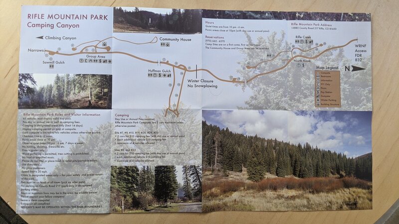
beyond the climbing. This wasn't intuitive to me. Drive through the climbing sector, and almost as soon as you leave the canyon, the first set of sites pop up with a big campground sign next to some buildings. As I understand it, the town of Rifle supports these sites. There are many, many more sites up the road, so if the ones you come to are full, just keep driving. We stayed at site 31, so there are at least that many. It was $12 per night which included your $5 day pass fee to use the park. No purified water exists (go to state park campground), but there are port-o-potties and trash dumpsters.
Per
james climbs:
Free camping at the "meadows" (the guidebook describes this just as well and is probably more accurate with distance but if you don't have it read on).
1. Go past the normal campgrounds for a few minutes (mile or so?) on the dirt road.
2. You'll see a fork in the road and an option to go left. Go left.
3. Put your vehicle into 4WD if possible, but it is not necessary (I've done it in a shitty 2WD Ford Focus). Go up this road.
4. You'll see another fork in the road. Go left.
5. The road gets windy and really bumpy. Persevere for another 3/4 to a mile or so. You'll see some small open space on your left at some point. Don't camp there. Keep going.
6. At some point the road opens up to an enormous clearing in the trees with a very large field on your right. This is the meadows. Camp anywhere here, it's 100% free.
Bats - conservation
See a bat on a route, give a shout. Climbers for Bat Conservation is working with climbers to understand bat ecology and why bats choose certain cracks and flakes. If you see bats, and want to tell them, here is their email (climbersforbats@colostate.edu) and their website ( climbersforbats.colostate.edu/).
Climbers for Bat Conservation is a collaboration between climbers, bat biologists, and land managers to understand where bats roost and where large populations may reside. They are interested in finding bats because a new disease, called white-nose syndrome ( whitenosesyndrome.org/), has killed millions of bats in North America. This collaboration has identified bat roosts throughout the U.S., and as far away as Norway and Bulgaria. CBC was developed by biologists who climb and they are advocates for climbing access and bat conservation. If you see bats while climbing, please let them know by emailing them at climbersforbats@colostate.edu, or visiting their website to learn more ( climbersforbats.colostate.edu/).
Rob Schorr
Zoologist, Colorado Natural Heritage Program ( sites.warnercnr.colostate.e…)
Director, Climbers for Bat Conservation
Robert.schorr@colostate.edu

[Hide Photo] Spring 2009. Photo: Angus Bohanon.

[Hide Photo] Looking for rest day fun? Here's an activity enjoyed by many visiting climbers.

[Hide Photo] Sir Nicholas, Order of the Stick Clip, Guardian of Campsite XVII.

[Hide Photo] Spring 2009. Photo: Angus Bohanon.


This limestone is awesome! This seems like a great place to build a foundation in the 5.12 range. No give aways though. Get ready for consistant climbing from bottom to top.
As for intimidation I found most people friendly. if not there are lots of routes to move on to. Sometimes a friendly hello will bring the same back. Just have fun!!!
Oh, one more thing, take longer rests here you'll need them ( up to 30 minutes or more)
Signed,
training harder to return anonymous coward Mar 9, 2004
This last weekend was only my 5th trip of the summer, but (just like every year) I've noticed that the Project Wall and the Arsenal seem to suffer severely from an infestation of leashless dogs. Dogs running unrestrained, doing there doggy things, all over the road while their masters blithely pose up some route that they have done 5 million times...never thinking that perhaps this is annoying to other climbers who are belaying, climbers who are smart enough to put their dogs on a leash and most importantly to the "local color" (remember they were there first) driving their enormous trucks at break neck speeds through the canyon on Labor Day Weekend.
Before you dismiss me as a dog hater, don't...I like dogs a lot and that is part of the problem for me...and I suspect some other people. I do not want to be subjected to witnessing the terrible scene of somebody's dog being run over right in front of me, and I cringe inwardly every time there is a near miss, which is often.
Unfortunately, it seems (why is this always the case) that it is the true hard core locals (you/we know who you are), the ones who should be the stewards of the area, who are by and large the worst offenders.
You peeps need to get it together, and set a better example to all the visiting fools who show up and think its just a big dog park!
I'll quit spraying now, and let the flaming begin...if anyone actually reads this...but even worse than watching a dog get killed would be to have a wall like the Project Wall get closed.Unlike most of you, I still have some routes to do there...and as we climbers are essentially a selfish and narcissistic lot, that really is the bottom line. I don't want my favorite climbing area closed down.
peace Sep 8, 2004
Now, personally, I've NEVER had any evil contacts with climbers up Rifle Creek (as we locals refer to RMP).
Quite a few of my friends and colleagues climb there regularly, and are nice sorts.
If you're nice, you won't have any problems with the "locals."
If you bring a big-city (L.A., New York) attitude, you'll be dismissed as an a-hole. Just a couple of cents from a local. Apr 13, 2005
Colorado Springs, CO
trying to get to Sardinia
Thank You! Apr 18, 2007
Carbondale, CO
Canine Wall: According to SplitterChoss.com, these were bolted by people from Climbing magazine. There are several climbs at 11a and below. While the sentiment is good, the execution is less so. Not enough cleaning was done, so there is alot of lichen and stuff, but more troubling is that there is a "a lot" of loose rock on these climbs.
For example, on Stem-o-Rama, the bottom two bolts are through a dirty garden-like area, with the only places aggressively cleaned are the bolt locations. In the upper dihedral, the crack and the left side of it are very loose: Several big blocks located directly on-route were pulled off accidentally (by experienced climbers), and several other on-route blocks are scarily loose and hollow.
My concern is that inexperienced climbers (who will be more likely to climb these) will likely pull stuff off onto inexperienced belayers. I can't recommend this area to newer climbers until some serious crowbar/cleaning goes into these routes. Aug 20, 2007
Carbondale, CO
Valid concerns, thanks for the input. Some of the routes at the Canine Wall are pretty damn dirty. I guess that's what you get on a shady, north-facing wall sometimes. Believe it or not, several folks have put a lot of time into cleaning these lines, including at last year's Rifle Cleanup. You wouldn't believe how dirty they were in the beginning.
I don't remember much in the way of loose rock, and can tell you from first hand experience the routes WERE picked over with a pry bar. Maybe some stuff came loose over the winter?
The mag is no longer in Carbondale, and with all the recent turnover there, it'll probably be impossible to get anyone out to finish up, so to speak. Maybe some civic minded folks will take up the task at this year's clean up.
I'll make a note of it in the info on splitter choss, thanks. Sep 17, 2007
Westminster, Colorado
Boulder, CO
Also, the 2008 edition guidebook is out! However, the Demons of Bosch are hard at work, putting up routes at a furious pace. Check out wolverinepublishing.com/rifle_new_routes.html for info on new routes and corrections, since the release of the guide.
I hope to see you all out there!
-aw Jul 1, 2008
Lakewood
The other great thing about Rifle is the people. I love the climbing community but the dedicated climbers at Rifle are top notch. I felt so welcome and everyone was so friendly. Thanks to everyone for making my first (and not my last) Rifle experience awesome. Jul 16, 2008
Ogden, UT
Glenwood Springs, CO
Boulder, CO
Denver, CO
Aurora, CO
Glenwood Springs, CO
Lakewood, CO
Denver, CO
Ogden, UT
Berkeley, CA
Carbondale, CO
Thanks May 16, 2013
Glenwood Springs, CO
Concerning new routes, there has been a lot of new route development since the '08 book, and a new book should be out soon. A lot of the new route stuff is on this site already. May 17, 2013
New Castle, CO
Somebody has cleaned my draws off of Head Full of Lead.
To whom has stolen my draws, they are not yours. They have been donated to the walls of this canyon not your gear closet.
Please return them to Summit Canyon Mountaineering, no questions asked. Jun 8, 2013
Grand Junction
There is one official "Rifle Falls State Park Campground" that is located a few miles before you get to the actual Rifle Canyon climbing. The sites are highly competitive to get and require a reservation months in advance. See the link below. Water is located here. I assume this is where most people fill up even if they aren't staying there.
Rifle Falls Camping parks.state.co.us/Parks/Rif…
There is also Rifle Gap State Park, which has 5 campgrounds, which is the reservoir that you pass by on your way to Rifle Falls, 5 or so miles before.
Rifle Gap parks.state.co.us/Parks/Rif…
Assuming you are a dirtbag climber, you will want to find the camping beyond the climbing. This wasn't intuitive to me. Drive through the climbing sector, and almost as soon as you leave the canyon, the first set of sites pop up with a big campground sign next to some buildings. As I understand it, the town of Rifle supports these sites. There are many, many more sites up the road, so if the ones you come to are full, just keep driving. We stayed at site 31, so there are at least that many. It was $12 per night which included your $5 day pass fee to use the park. No purified water exists (go to state park campground), but there are port-o-potties and trash dumpsters. Jul 28, 2013
Carbondale, CO
Elizabethtown, Pennsylvania
Nederland, CO
Glenwood Springs, CO
The camping fee is increasing to $10 this year. Mar 21, 2014
Breckenridge, CO
Boulder, CO
I visit Rifle these weekends passing recently and make many bold, polished flash. Many holds of glassy texture and jagged, blocky, angular shape and power sidepull, most enjoyable.
I find the climbing most enjoyable and find many flash at the 5.13 level perhaps not so difficult. However, I am slight disturb by the high amounts of polish, it makes me scared for my feet slipping on some most difficult route. Some holds seem more slippery than a weeks-old, slimy fish-head. The route they look to be chalk-caked shoe blackened rivers of snot.
Also, I would be freaked out by everyone doing the wearing of the kneepads and perhaps the copious amounts of righteous bros, who would not acknowledge you as a human being if you cannot do the 5.13 climbing rocks. Is there perhaps a large plumbing project going on I may not know about, requiring the workers wearing kneepads? I have never seen so many plumbers and righteous bros climbing after work. May 7, 2015
Carbondale, CO
Boulder, CO
Climbing friend storm,
I see you attempt to deliver me a vicious wang-slap over the tubes of the internet. I block your wang-slap and say to you this. Are you not respecting my authoritai? Perhaps you become enrage because you feel deep in your heart that you may be a righteous bro with fancy pants, and know that climbing is only a part of going to Rifle and being seen in a scene and proving your worth as a human being by advance gradings of the climbing rocks is much big part for many climbing friend there, yes? myah? I think yes myah.
We will meet at high noon and have a flash-off, and see who make more bold flash! And the winner will achieve glory, never ending adulation, and a lifetime supply of cheesesteaks at the losers expense, myah? Sep 1, 2015
Salt Lake City, UT
Boulder, CO
I demand to know the "conditions," even though I, like everyone not ritard, know that some routes will be wet and some will not.
I need climb proudly flash 5.14 and practice the Rifle no brake hand Grigri technique, inattentive at all times, and with other hand resting on device contrary to manufacturer safety instructions, and unnecessary excessive loop of slack hanging down to knees or lower, so that I may be less attentive and do not have to anticipate my climber movement, as is the rifle way. May 13, 2016
Fayetteville, AR
Btw, last Sunday at Arsenal, I left behind a grey Black Diamond harness, LA Sportiva Solutions, a chalk bag, and a Nalgene. Please contact me at 301-606-2002 if you have any info regarding my lost items. Any help is greatly appreciated! Oct 4, 2016
Denver, CO
Rifle CO
TLDR: Navigate here: 39.749278,-107.701219
1. You'll end up continuing past the campgrounds on the dirt road. Specifically, from the junction with Sawmill Gulch Road (Huffman Gulch, or the main Rifle campground area), continue on the dirt road (road 217 which becomes road 217/832) for 2.0 miles (or 8 minutes) until you reach a fork in the road with an option to go left. See goo.gl/maps/pkZBQjgqtqL2 for the specifics.
2. Go left, which takes you onto Forest 832 Route. Put your vehicle into 4WD if possible, but it is not necessary (I've done it in a shitty 2WD Ford Focus). Stay on this road for 0.6 miles uphill until you reach another fork in the road with an option to go left. goo.gl/maps/MF8jqgu9JYD2
3. Go left again (this is a continuation of Forest 832 Route). The road gets bumpy. Stay on this road for 0.8 miles (still uphill). On the way, you'll see some small open space on your left at some point. Don't camp there. Keep going. At some point the road opens up to an enormous clearing in the trees with a very large field on your right. This is the meadows. Camp anywhere here, it's 100% free. goo.gl/maps/fxViv9Syoz82
The meadows are at 8,000 ft. Bring layers, even in the middle of August. Jul 21, 2017
Glenwood Springs, CO
Logan, UT
Rifle is cool. Jun 20, 2020
Las Vegas, NV
Salt Lake City, UT
Spent most of our first climbing day disputing with the ranger & Lindners. Thankfully the ranger sided with us but still a day wasted unfortunately. Save yourself the trouble, and be meticulous when getting set up. Sep 19, 2022