Upper Wall
California
> Lake Tahoe
> I-80 Corridor
> Bowman/Emeralds
> Emeralds
> Gorge
> Upper Gorge
 Access Issue:
 Flood Danger
Details
WARNING! As the sign posted at the parking lot reminds you, this area is subject to sudden and severe flooding, especially in run off times (spring and winter). Most of the climbing routes in the gorge are in the potential flooding areas, as walls of the gorge sit below several LARGE floodgates from Lake Spaulding. These gates may open at any time, and as the sign in the parking area states, there may or may not be warning. Being in the gorge when the gates open would probably mean death, and being in the other climbing areas will mean that your exit is blocked until flood waters reside. Read all posted signs in the parking area, and also beware that these may not be updated.
Access Issue: No overnight camping on PG&E property
Details
Noticed several tents while walking into the emeralds climbing area this last weekend ( 5/20/17 ). PG&E (Pacific Gas and Electric) has posted several signs at the gate and other areas that state camping is NOT allowed. Please respect this so that access does not become an issue! Thanks in advance,
Colby W.
Description
(UPDATED 4/2013) MUCH OF THE INFORMATION BELOW THIS PARAGRAPH IS NO LONGER ACCURATE AS ADDITIONAL FLOODING HAS CHANGED MUCH OF THE LANDSCAPE. THERE IS NO LONGER A WISHING WELL AND WHERE THE WISHING WELL WAS IS NOW LARGE BOULDERS. THIS ENTIRE AREA IS CURRENTLY UNDER DEVELOPMENT BY MIKE CARVILLE, JOSH HORNIAK AND OTHERS. THERE WILL BE A GUIDE PUBLISHED IN THE NEAR FUTURE WHICH WILL PROVIDE COMPLETE INFORMATION ON THE AREA. THE WARNING AT THE BOTTOM OF THE DESCRIPTION CONTINUES TO BE VALID. HOWEVER, ONCE THE WATER LEVEL IN SPAULDING LAKE IS BELOW THE BOTTOM OF THE OUTLET GATES, THIS WARNING NO LONGER APPLIES.
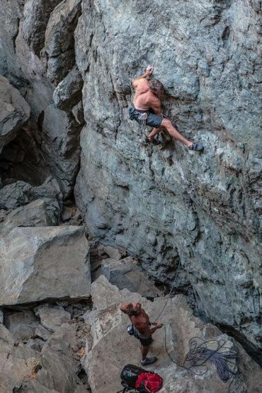
This is located in the highest section of the gorge, and is quite a long and strenuous hike to get into from below. From the base of these routes, you will be about 100 feet below the large floodgates from Spaulding Lake.
One of the few places in the gorge where the routes and bolts seem to have survived the many rushes of water "unscathed". I say this only because I didn't see the rock proir to all the damage that scoured the wishing well routes. Most of the routes are on the south wall of the gorge.
You will find sport routes with bolts of extremely questionable durability here. The holds you will swear came straight out of a gym, and make the climbing quite unlike most ofther outdoor experiences. This section of the gorge is approximately 30 feet high.
WARNING! As the sign posted at the parking lot reminds you, this area is subject to sudden and severe flooding, especially in run off times (late spring and late fall). The walls of the upper wall of the gorge sit below several LARGE floodgates from Spaulding Lake. These gates may open at any time, and as the sign in the parking area states, there may or may not be warning. Being in the gorge when the gates open would probably mean death, if the gates opened while you were in the area of the upper wall and actually in the gorge, you would probably have about 10 seconds of reaction time to move, and there is no really fast exit out of this area, and no higher ground without climbing a route or going up to the floodgates themselves. Read all posted signs in the parking area, and also beware that these may not be updated.
Getting There
The paragraph below is no longer valid (10/14) as a gate has been installed and you can no longer cross the dam.
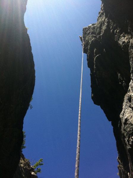
(4/2013) THE ACCESS INFORMATION BELOW THIS PARAGRAPH IS OUTDATED.THE EASIEST WAY TO ACCESS THIS AREA IS TO PARK IN THE SPAULDING LAKE BOAT LAUNCH PARKING AND WALK OVER THE DAM TO THE FIRST SET OF FLOOD GATES (APPROX 1/4 MILE PAST THE DAM). JUST BEFORE THE FLOOD GATES GO TO THE OUTLET SIDE OF THE FLOOD GATES AND CROSS THE DRAINAGE. CONTINUE ON THE RIM OF THE DRAINAGE FOR APPROX 300 FEET UNTIL YOU COME TO SOME METOLIUS RAP ANCHORS LOCATED ABOUT SHOULDER HIGH. (THERE ARE OTHER ANCHORS LOCATED AT YOUR FEET OR OVER THE EDGE BEFORE YOU GET HERE BUT DON'T RAP ON THESE) RAP OFF THESE ANCHORS USING A 70M ROPE AND YOU CAN CLIMB BACK OUT THE SAME WAY YOU RAPPELLED ON A 10C CLIMB.
Added 10/14:
A GOOD WAY TO ACCESS THIS AREA AND TO GET TO THE BOTTOM OF THE GORGE IS TO START WHERE THE BOWMAN LAKE ROAD CROSSES THE YUBA RIVER AND FOLLOW THE INFORMATION PROVIDED IN "PHOTO'S OF THE EMERALDS" (ON THE EMERALDS MAIN PAGE) A 3 PAGE GUIDE TO THE BENCHES AREAS. YOU WILL SEE A NOTE STATING "TRAIL TO GORGE, WISHING WELL ETC" THIS POINT ON THE GUIDE IS JUST PAST KUDOS (100 METERS OR SO) YOU WILL TURN LEFT AT A CAIRN (IF YOU TURN RIGHT HERE YOU WILL GO TO FAST FOOD WALL) FOLLOW THIS TRAIL AND CAIRNS TO A POINT ABOVE THE GORGE WHERE YOU WILL GO DOWN STEEP TALUS TO THE BOTTOM OF THE GORGE CLIMBING.
The following approaches are also possible (Approach #2 I see no reason to go all the way to the flood gates. Just come into the lower gorge as described above).
Approach #1:
Approach time: 35 - 75 minutes.
From the parking lot head accross the bridge and up the gated entry road. Stay on the road for .6 miles until it ends un a gravel / logging area.
From here, stay in the valley and travel up the boulder outwash for quite a while (tough to judge distances due to the nature of the terrain) until you can see the large gorge on the right.
Go up to the mouth of the gorge, and instead of going inside, head up through the trees and rocks to the right following (sometimes!) a narrow deer trail.
This will continue to parallel the gorge, until you get up to the flood gates. The top anchors of the climbs are right on the edge 75 feet from the mouth of the gorge, and you can either rappell in, or continue up to the gates and walk back down to the routes.
Approach #2: Approach time: unknown, though if you've got a boat it will be faster and less strenuous than approach #1.
It also seems possible to approach this and other areas in the gorge from above, by taking a boat off of Spaulding Lake and heading over to the floodgates on the west end of the lake. I personally have not treid this approach, but from what I saw at the floodgate, it certainly seems possible.
To get to the Spaulding lanuch area from I-80, exit on the 20 headed towards Nevada City. About 1/2 a mile later, take a right on Lake Spaulding road towards Camp Spaulding. There is a boat launch 1/4 mile after the Camp.
Take your boat accross the lake to the west end, where you will find the flood gates. Exit your boat on the shore near the floodgate, and find your way to the other side of the gate. The climbing is located 150 feet downhill from the gates in the gorge itself.
Routes from Left to Right
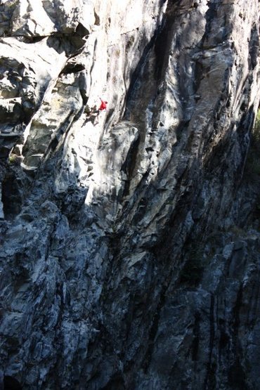
![The mega classic Resurrection .11c. Emeralds Upper Gorge. photo: jim thornburg.]()
[Hide Photo] The mega classic Resurrection .11c. Emeralds Upper Gorge. photo: jim thornburg.
![Ian Texeira looking strong on Macho Man .12d. Emeralds, CA pic: josh horniak]()
[Hide Photo] Ian Texeira looking strong on Macho Man .12d. Emeralds, CA pic: josh horniak
![Hansi Standtheiner - third ascent of Drama Queen .12a. Emeralds Upper Gorge. pic: josh horniak]()
[Hide Photo] Hansi Standtheiner - third ascent of Drama Queen .12a. Emeralds Upper Gorge. pic: josh horniak
![Mike on Super Alpine .11a. Emeralds, Upper Gorge. pic; josh horniak]()
[Hide Photo] Mike on Super Alpine .11a. Emeralds, Upper Gorge. pic; josh horniak
![Hansi Standtheiner on Five Minute Hero .12-, Emeralds Gorge (upper).]()
[Hide Photo] Hansi Standtheiner on Five Minute Hero .12-, Emeralds Gorge (upper).
![Brad Johnson on Sub Zero .11b. Emeralds Upper Gorge.]()
[Hide Photo] Brad Johnson on Sub Zero .11b. Emeralds Upper Gorge.
![Ian Texeira working the mega steep Grail Project .13b. Emeralds, CA. pic: josh horniak]()
[Hide Photo] Ian Texeira working the mega steep Grail Project .13b. Emeralds, CA. pic: josh horniak
![Rapping into the Wishing Well. Upper Gorge, Emeralds.]()
[Hide Photo] Rapping into the Wishing Well. Upper Gorge, Emeralds.
![Mike Carville mid way up on 5 Minute Hero .12- Emeralds, Upper Gorge. photo: jim thornburg.]()
[Hide Photo] Mike Carville mid way up on 5 Minute Hero .12- Emeralds, Upper Gorge. photo: jim thornburg.
![Mike Carville finishing Repo Man .12d. Wishing Well, Emeralds Gorge. pic: josh horniak]()
[Hide Photo] Mike Carville finishing Repo Man .12d. Wishing Well, Emeralds Gorge. pic: josh horniak
![Mike and Josh working Game of Thrones .12c. Emeralds Gorge.]()
[Hide Photo] Mike and Josh working Game of Thrones .12c. Emeralds Gorge.
![Tom Addison on Whirl Pool .12a. Emeralds Upper Gorge]()
[Hide Photo] Tom Addison on Whirl Pool .12a. Emeralds Upper Gorge


 Continue with onX Maps
 Sign in with Facebook


Approach: from above steel monkey traverse right up slab to top. Head (left) east through forest past Kudos/Fast Food Cliff then another 15 minutes along slabs to Gorge - follow trail/karins. Enter Middle Gorge or hike up hill to Spaulding Lake then descend spill way to rap station into Wishing Well/Upper Gorge. About 35 minutes from parking area. Mar 30, 2013
Meadow Vista
Asheville, NC
1. It has become somewhat of a dangerous area because of rock fall (an entire section of the gorge collapsed) and the ever-present flooding risk
2. It is rarely visited now that the dam access is closed, making it the farthest approach of all areas in the emeralds.
I'm hard-pressed to put much energy into the gorge area, but I'm more than happy to watch/approve/validate edits and additions that others, perhaps more stoked on the area, put in. That said, I'll eventually go through what's up here now to make sure it still exists! Jan 18, 2018