
 Continue with onX Maps
 Continue with Facebook


Punani Area/North Canyon Bouldering
Use onX Backcountry to explore the terrain in 3D, view recent satellite imagery, and more. Now available in onX Backcountry Mobile apps! For more information see this post.
| Elevation: | 5,400 ft |
| GPS: |
39.35561, -104.76303 Google Map · Climbing Area Map |
| Page Views: | 28,300 total · 225/month |
| Shared By: | Andy Librande on Dec 17, 2013 |
| Admins: | Leo Paik, John McNamee, Frances Fierst, Monty, Monomaniac, Tyler KC |
 Access Issue: Historical seasonal raptor closures with 2023 updates
Details
Access Issue: Historical seasonal raptor closures with 2023 updates
Details
Per Castlewood Canyon: there is a new closure for nesting raptors this year: Five and Dime will be closed March 1st through July 31st. If you have any questions please feel free to reach out to me, Rachel Chaffee (Park Ranger) at dnr_castlewood.canyon@state.co.us or by phone at 303-688-5242.
Per Garrett Garner-Wells:
the current raptor closures, announced by CPW and reported on Denver7:
The following climbing route closures are currently in place:
- Morning Sun Wall is closed March 1-July 31.
- Porky’s Wall is closed March 1 - July 31.
- Vultures Wall is closed March 1-July 31. (per Rachel, CCSP Ranger, dnr_castlewood.canyon@state.co.use or 303-688-5242)
- Shakespearean Theater is closed March 1-May 31.
- Mind Meld is closed March 1-May 31.
As of 2020:
There is a very new and active nest of owls midway up the cliff at the north end of the Neanderthal Wall between Cro-Mag and Up The Red. There is no active nest around the south end of Neanderthal Wall.
As of June, 2017:
The 3 toprope routes at the far south end of Neanderthal Wall (far north end of Allied Wall) have a nesting pair of Snowy Owls. Please stay off these routes until further notice. The park has been notified and hopefully some signage will be put up. The route Rock Rat is included.
As of March 7, 2012:
Shakespearean Theater - restricted March, April, May.
Mind Meld - restricted March, April, May.
Porky's Wall - restricted March, April, May, June, through July 31.
Vulture Wall - restricted March, April, May.
Morning Sun Wall - restricted March, April, May, June, July.
Description

This cluster of river-polished boulders sits in the valley along the east side of Cherry Creek and is home to the classic problem Punani.
The northern-most developed bouldering area east of the road this area offers a few highly concentrated problems; however, outside of these few problems the area is sparse of established climbs. Apparently the area can be known for its heavy concentration of ticks in spring through summer months.
There may still be potential on many of the boulders that lay on the hillside above this area as well.
Please note that while it appears this area is nearby to the Nine Lives Boulder (which technically is just south along the creek), it is much more spread out then it first appears. You can reach Nine Lives and Central City from here by continuing along the Creek Bottom trail. Bushwhacking on the east side of the river is reserved for those looking for a challenge.
Getting There
Enter through the West Entrance (which is also commonly called the North entrance).
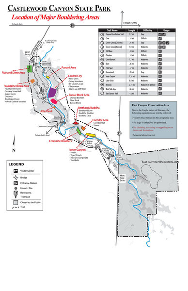
![]() Location of major Bouldering Areas throughout Castlewood Canyon. This covers the major areas that have been developed and documented. Please let me know if anything is incorrect or needs updating. As of July, 2010. .
Location of major Bouldering Areas throughout Castlewood Canyon. This covers the major areas that have been developed and documented. Please let me know if anything is incorrect or needs updating. As of July, 2010. .
Park in the 1st parking lot to your left just after you pass the ranger kiosk, this is called the Lucas Homestead Parking Lot (remnants of an old stone structure prominently stand over the parking lot).
Take the Homestead Trail down towards the creek for ~0.3 miles where you will run into a junction for Rim Rock trail or Creek Bottom trail. At this point, you can take either trail although the Creek Bottom is the easiest/most direct to use.
Creek Bottom: Head south (into the canyon) for another 250 yards or so until right before where the trail enters thick pine forest. Across the river you should be able to spot the clean-looking blocks of Punani (depending on time of year the river may be obscured by foliage along the trail). Cross the river (usually no issue of getting wet). Punani Boulder sits facing the stream in a large cluster of tan-colored boulders.
Rim Rock: Turn on Rim Rock trail and cross the bridge. On the otherside of the bridge, there is a field that you cross and keep an eye open for faint paths. Head towards the riverbanks, and follow that until you run into the cluster of Punani Boulders (there is also an old truck trail too that can be used). This way may not be best if the willows are thick. This way may be best if the river is running high.
Also, note a few other boulders sit in the area and will have specific descriptions on how to get to them.
Classic Climbing Routes at Punani Area/North Canyon
Mountain Project's determination of the classic, most popular, highest rated climbing routes in this area.


Weather Averages
|
High
|
Low
|
|
Precip
|
Days w Precip
|
Prime Climbing Season
| J | F | M | A | M | J | J | A | S | O | N | D |
| J | F | M | A | M | J | J | A | S | O | N | D |


All Photos Within Punani Area/North Canyon
Most Popular · Newest · RandomMore About Punani Area/North Canyon
Printer-FriendlyWhat's New
Guidebooks (11)


1 Comment