|
|
Ben Watson
·
Sep 8, 2015
·
Tempe, AZ
· Joined Feb 2013
· Points: 45
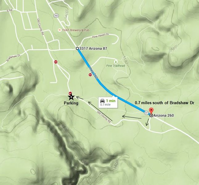
The landowner near the "former" parking for Isolation Canyon has been busy as of late. Friends and I ventured down the usual approach via Bradshaw dr on Sunday to find several Private Property No Trespassing signs along the road. Just beyond where the road forks left is a row of boulders and berms blocking access to the dirt road that leads to the Forest Service land gate.
Also the dirt road just south of the turn-off to Pine Trailhead is blocked with boulders. We parked here and walked around the perimeter of the barbed wire fence to get to the Forest Service gate, which is now locked.
From talking to others that day, easiest new approach is the turn-off ~0.7 miles south of Bradshaw Dr with a short drive to get back north to where the Old County road meets up with the AZ Trail. Easier to depict on a map:
|
|
|
DesertRat
·
Sep 8, 2015
·
Flagstaff, AZ
· Joined Jul 2010
· Points: 196
|
|
|
Manny Rangel
·
Sep 9, 2015
·
PAYSON
· Joined Jan 2006
· Points: 4,789
That sucks. Great info. I'll check into what happened. Taking the road you described is near the original trail into the climbs. We could take a look at that as an alternative.
I thought the area blocked off was public. My big surprise here.
|
|
|
Manny Rangel
·
Sep 13, 2015
·
PAYSON
· Joined Jan 2006
· Points: 4,789
I've contacted Pine Fire Dept. I'm not sure it's a good idea to block access to the gate.
|
|
|
Manny Rangel
·
Sep 17, 2015
·
PAYSON
· Joined Jan 2006
· Points: 4,789
Bump
If you go up this weekend be sure to let us know if anything has changed.
This is marked as National Forest on the map. I'm not sure what is going on. I haven't received a response from their FD.
|
|
|
K-Tanz
·
Sep 17, 2015
·
Phoenix, AZ
· Joined Sep 2010
· Points: 226
Thanks for looking into it, Manny. Not sure how anyone thinks chaining a forest service gate is a good idea
|
|
|
Ben Watson
·
Sep 17, 2015
·
Tempe, AZ
· Joined Feb 2013
· Points: 45
Thanks for checking on things, Manny.
I'm still uncertain on why the owner(s) would block the road, but it does appear that the parcel(s) north of the forest boundary fence line, all the way to the highway fall under private ownership.
http://gis.azland.gov/webapps/parcel/?loc=-111.4452,34.3720,16&layers=3,1,0
Like you said, at least the canyon and the approach trail are located on National Forest land. Also, I don't foresee anything happening to the "AZ Trail" in its vicinity, so that should continue to directly benefit access to the canyon.
|
|
|
Greg Opland
 ·
Sep 17, 2015
·
Unknown Hometown
· Joined Nov 2001
· Points: 181
·
Sep 17, 2015
·
Unknown Hometown
· Joined Nov 2001
· Points: 181
Skip the FD and ask the USFS what the deal is.
In this age of "better to ask forgiveness than permission", someone blocking a road or chaining a gate (especially in a backwoods spot like this) doesn't necessarily indicate they have ownership of the area in question.
|
|
|
Manny Rangel
·
Sep 17, 2015
·
PAYSON
· Joined Jan 2006
· Points: 4,789
Thank you for posting the info Ben. Laurel Arndt said she is pursuing the TNF access question. She also said the property was purchased in 2007 and he could tie up access forever.
|
|
|
Ben Watson
·
Sep 17, 2015
·
Tempe, AZ
· Joined Feb 2013
· Points: 45
I was curious, so I pulled up the parcel map for the area via Gila Co's assessors site (all public info, not trying to be a creep)
ftp://ftp.gilacountyaz.gov/Public/Assessor/Parcel/301
In particular, we're looking for the following area:
301-34 Map
Based on the 2015 assessor records, there are really four independent land managers in the vicinity of the former access road/trail (parcels 8E, 8F, 8G, and 10A). Searching for "301-34" from Gila Co. Assessor's site yields the owners of the above map.
The land owner for the area in question, parcel 8E, also owns parcel 7F, further down Bradshaw road. Both large parcels of land are currently listed as vacant. From my visits to the area, I can attest that there are no structures on either plot (can verify via google maps too). Also interesting to note is that the old County road that used to provide climber access isn't listed on the assessor's map once it turns SW at the eastern corner of 8F. We used to park just beyond this point and walk the rest of the way to the forest gate. For that matter, there are a number of worn roads throughout this 29 acre parcel, including one back out to the highway, now all blocked from entry.
Who knows what they intend to do with their land -- that's their business. But I agree with the notion that access via the old means will be tied up for the foreseeable future. Seems like ensuring access with Tonto NF is the best scenario going forward -- Thanks Laurel & Manny for looking into that.
|

 Continue with onX Maps
 Continue with Facebook