
 Continue with onX Maps
 Continue with Facebook


Heaven's Gate Rock Climbing
Use onX Backcountry to explore the terrain in 3D, view recent satellite imagery, and more. Now available in onX Backcountry Mobile apps! For more information see this post.
| Elevation: | 8,865 ft |
| GPS: |
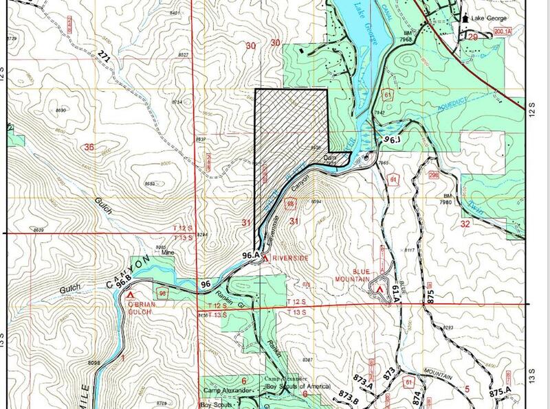
38.9329, -105.3688 Google Map · Climbing Area Map |
| Page Views: | 83,091 total · 530/month |
| Shared By: | Hans Hoffman on Jun 11, 2011 · Updates |
| Admins: | Leo Paik, John McNamee, Frances Fierst, Monty, Monomaniac, Tyler KC |
 Access Issue: Seasonal Raptor Closures January 1- July 31st, 2016-2021
Details
Access Issue: Seasonal Raptor Closures January 1- July 31st, 2016-2021
Details
For 2022: per Daniel Bryant: they did extend the order, but what I found was that the closed area does not encompass any of the common climbing areas within Elevenmile Canyon.
Seasonal Closures in effect January 1-July 31st, 2016-2021.
For details visit:
fs.usda.gov/Internet/FSE_DO…
Maps:
fs.usda.gov/Internet/FSE_DO…
fs.usda.gov/Internet/FSE_DO…
Contact phone number: (719) 553-1400.
Seasonal Closures in effect January 1-July 31st, 2016-2021.
For details visit:
fs.usda.gov/Internet/FSE_DO…
Maps:
fs.usda.gov/Internet/FSE_DO…
fs.usda.gov/Internet/FSE_DO…
Contact phone number: (719) 553-1400.
Description

Tucked away south of Elevenmile Canyon proper, Heaven's Gate will make a sport climber's dreams come true. This secluded and uncrowded area is all sport climbing on solid, overhanging granite, with awesome patinas, slopers, and beautiful crimps. Plus, the approaches are no longer than 10 minutes. Heaven's Gate became a reality after Nathan and Lauren Hollingsworth discovered it with Ben Schmitt, Brian Rhodes, Scott Hahn, Perri Rothweiler, and Logan Davis developing this crag heavily over the summer of 2010.
You will find no trouble camping here with no fees or access issues. Most routes have chain anchors with fairly optimal belaying. Classic routes are Intercontinental, Shotgun Pinata, and Fight or Flight to name a few. For the ambitious type, there are plenty of sweet open projects and bouldering here to be sent so get on it quick!!
And on your way out don't forget to grab a Flow-storm or a Mountain Burger at the small gas station (the one with the "Beer Store" sign). Finally, with Ben's permission, I provide this data, so ALL credit goes to him and the folks aforementioned and his new book -- Eleven Miles to Freedom: The Rock Climber's Guide to Elevenmile Canyon.
Getting There
The following is verbatim from Ben's book: Take Co Rd 96 out of Lake George (which turns into FS 244 past the fork which leads to entrance of the main canyon), all the way around Blue Mountain where it rejoins Co Rd 98 at a large fork. Continue up the small hill, and turn right at the white sign labeled "Circle C Ranch", and take the right fork onto FS 244 (the left fork leads to the Circle C Ranch). Follow this for 0.4 miles, cross a seasonal puddle, and turn left immediately after that onto FS 244A for 0.2 miles, through a meadow where the road splits for 40 feet then rejoins, and turn left on FS 244B. Continue up the fill for 0.5 miles to where the road dead ends at a cul-de-sac and the parking for the crags.
Per Rich F.: from Colorado Springs from US Hwy 24, take a left at the small red "Saddle Up Realty" building in Florissant on Teller County Road 46, and drive 2.4 miles to where the road forks. Take the right fork, which is CO-98 and drive 1.8 miles until it merges with Blue Mountain Road. Drive another 0.9 miles and you will be at the right turn for the Circle C ranch and FS-244. Continue with the description up top. This short cut on good roads cuts the corner off from Florissant to Lake George, saving about 5 miles of driving. Once on FS-244, a high clearance vehicle is recommended for the remainder of the drive.
- Note: you will want to take a vehicle with high clearance.
Per Rich F.: from Colorado Springs from US Hwy 24, take a left at the small red "Saddle Up Realty" building in Florissant on Teller County Road 46, and drive 2.4 miles to where the road forks. Take the right fork, which is CO-98 and drive 1.8 miles until it merges with Blue Mountain Road. Drive another 0.9 miles and you will be at the right turn for the Circle C ranch and FS-244. Continue with the description up top. This short cut on good roads cuts the corner off from Florissant to Lake George, saving about 5 miles of driving. Once on FS-244, a high clearance vehicle is recommended for the remainder of the drive.
Classic Climbing Routes at Heaven's Gate
Mountain Project's determination of the classic, most popular, highest rated climbing routes in this area.


Weather Averages
|
High
|
Low
|
|
Precip
|
Days w Precip
|
Prime Climbing Season
| J | F | M | A | M | J | J | A | S | O | N | D |
| J | F | M | A | M | J | J | A | S | O | N | D |


All Photos Within Heaven's Gate
Most Popular · Newest · RandomMore About Heaven's Gate
Printer-FriendlyWhat's New
Guidebooks (13)


11 Comments