
 Continue with onX Maps
 Continue with Facebook


Gear Review - "Red River Gorge Rock Climbs" for the iPhone
|
|
Red River Gorge Rock Climbs (iPhone app)by Ray EllingtonIt may or may not be “the future of guidebooks” as some would have it, but the much-anticipated new edition of Ray Ellington’s guide to climbing in the Red River Gorge is a significant achievement: the first complete guidebook issued as an app for the iPhone. And if you’re an iPhone owner who spends any time climbing at the Red, this app is a must-have.Red River Gorge Rock Climbs for the iPhone was released by Wolverine Publishing last week. It incorporates the updates that will be included in the “paper” version of the third edition of Ellington’s popular RRG guide. That hard copy version is due out in June. News has been circulating for months on climbing websites that the revised edition of the guide would be published as both a conventional book and as an iPhone app. Ellington’s second edition guide has set a high standard for climbing guides since it was published three years ago, so as an iPhone user, I was immediately intrigued. Within 24 hours of its release, I eagerly downloaded the app to my iPhone, and I’m happy to report that the app version of the guide maintains the high quality and content of the print version of the guide while providing some useful additional capabilities. One important detail to get out of the way up front: the RRG iPhone guide is not dependent on cell phone coverage. This has been a matter of some confusion on climbing message boards. As an app, all guide content is self-contained, so with the exception of its interactive maps, it’s fully functional even in areas where there is no cell phone/data coverage at all. This is contrast to web-based applications (such as the iPhone version of the Mountain Project website), which must be connected to the internet to function. Content-wise, there’s not a lot of difference between the paper guide and the iPhone version. There are almost 1,800 routes included in the new edition, about 200 more than in the second edition, but most of the route descriptions remain the same as in the older guide. The familiar inside-the-cover map and maps for the various regions are also maintained. What’s new and improved in the iPhone guide is presentation and navigation. There are a number of ways to get where you want to go in the app, and these are often much more convenient than what’s possible with the paper guide. First piece of good news: it’s easy! The iPhone guide interface will be familiar to anyone who’s used other such apps. Everything is very intuitive, so there’s no real learning curve in using the guide. The splash screen (featuring Chris Sharma cruising a casual 5.14c) is followed by the main “Explore” screen that lists the various regions in the Red. A ribbon of links at the top of the screen will take you to pages on history of the Red, trip beta, access issues and other information. Along the bottom of the screen are the available nodes that can be used to find what you’re looking for: Explore (default); Search; TickList; Log; and Navigate. 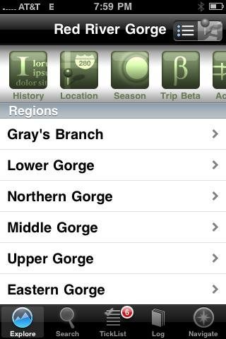 The Explore node is analogous to the table of contents of the paper guide. From here, you can drill down by region, then crag, then list of routes. If you already know what region your destination is in, this is probably the quickest way to find your route. Once you’ve navigated to the crag you’re looking for, there’s a ribbon of links at the top of the screen for viewing a description of the crag; the approach; weather conditions; and any access notes. If there’s a cliffline topo associated with the crag (not all walls have these), you’ll find a pushpin icon at the top right to bring up the topo. Scroll through the list to find your route, then tap it to bring up a route description. From the route description page, you can scroll through the rest of the routes at that crag by sliding the screen left or right, as you would with photos. Here’s a place where you might notice a departure from the guidebook: the routes are not necessarily in the same order. Roadside Crag is a good example: in the print guide, Roadside Attraction is the first route listed because it’s the first line you come to when you reach the end of the approach trail. In the iPhone guide, the routes are listed in order from the left end of the wall to the right end; Roadside attraction is in the middle, so it’s route #14, not route #1. I consider this a much more sensible approach. It’s not consistent, however; as in the book, the iPhone app numbers routes at Torrent Falls from the middle, not from the left end. If I had to single out one feature of the app as the most outstanding and useful, it would probably be the Search node. By comparison with thumbing through the paper book’s index or table of contents, this is fantastically easy and customizable. You can search for routes by almost any criteria you can think of: by name; by grade; by region; by style (sport or trad). Here’s a screenshot of a search for all trad climbs between 5.7 and 5.10 that are located in the Natural Bridge region with at least a two-star rating:  Once you have your search results on screen, scroll down the list to find a particular route, then touch the route to view its description. From there, you can scroll to the next or previous route in the results by sliding left or right. Another cool aspect of the search feature is that your search criteria are preserved as long as you’re in the Search node. Viewing a route description doesn’t clean the slate; you just return to the results screen. The search criteria are reset, however, if you navigate from a route description to its home area by touching the Explore icon at the top right of the screen. One unfortunate gap in the Search facility is the ability to search for crags by name. If you don’t know which region Pebble Beach is in, or the name of a route there, you’re going to have to do some exploring. The Navigate node is another great feature in terms of finding your way to the crag. Touching the Navigate icon brings up a Google Earth-style map of the Red River Gorge region, with pushpins for the various climbing regions (e.g., Muir Valley). By tapping the configuration button at the top right corner of the screen, you can change the view to show pushpins for regions, walls or “info” (local amenities), or any combination of the three. Minor annoyance: this configuration isn’t saved but resets to the default view (regions only) every time you leave the Navigation node.  Double-tapping the screen will zoom you in on the map so you can see exactly where you’re going. And if you tap an individual pushpin, this brings up a link that will take you to the particular region or crag represented by the pushpin. As noted earlier, the maps in Navigation are dependent on either GPS or cell phone coverage. GPS coverage tends to be more reliable than cell coverage in the Red, but there will be some locations like deep valleys where you won’t get either one. Two other cool and handy features are the TickList and Log nodes. As you’d probably guess, you can add routes that you want to climb to the ticklist, and you can track routes you’ve already climbed in the log. Any route that’s been added to the ticklist or log will show up with a check mark beside it – green if you’ve climbed it, clear if you’re planning to do so. There’s even a link to email your ticklist or climbing log to yourself or someone else for posterity. Another fun little Easter egg is navigating to a route from the cliffline topo. When you touch a route number in topo view, it brings up a link that will take you to the corresponding route description. In addition to the cliffline diagrams, the iPhone guide includes numerous photos showing the route lines, much the same as in the paper guide. There are also lots of climbing photos; Ellington has encouraged climbers to submit their action photos for inclusion in the app, as it doesn’t have the same constraints on number of photos as the paper guide. Any of these can be viewed in full-page mode by tapping the photo. One thing the iPhone guide gives you that a print guidebook can’t is periodic updates. Errors in a print guidebook are there forever. You may find some of the usual glitches in the iPhone app (typos, a route out of order, etc.), but these can be fixed via updates from the iTunes store. The publisher is promising free updates to the RRG app for the next two years. If you’re used to spending four or five bucks for a game or other app for your iPhone, the $29.99 price tag for the RRG guide may seem stiff. But bear in mind that this is not just a typical app, but a full blown guidebook, so the price is in line with what you’d pay for a paper guide. It’s also worth noting that the price for many guidebooks is subsidized by advertising; the iPhone app has no ads. Additionally, Wolverine is offering the new print version of the RRG guide for $19.95 (discounted from $36) to purchasers of the iPhone app. Summary Is the iPhone guide perfect? Will it replace the print guide? My answer to both questions is no. For something to pore over with your climbing partner while sitting around the campfire, the print version would still be my choice. And as noted earlier, there’s a couple of minor things I’d change in the app, especially the ability to search for crags by name. But having the guidebook with you at the crag on your iPhone instead of a bulky and heavy print version is a real plus. And the nifty search feature alone is worth the price of admission. Overall, the iPhone guide is a killer app, and I highly recommend it. NOTE: I plan to put the iPhone guide through its paces on my next trip to the Red in a couple of weeks; I’ll update this review with my at-the-crag experiences when I get back. youtube.com/watch?v=iQH3ZnM… Red River Gorge Rock Climbs (iPhone app), by Ray Ellington, $29.99, published by Wolverine Publishing. Available only online through the Apple iTunes store. Full disclosure: a copy of Red River Gorge Rock Climbs (iPhone app) was provided to Mountain Project at no charge by the publishers. |

|
Great review. As a creator of this site, I'm jealous of the app! |
|
|
Just wanted to let everyone know v1.10 is released with some major updates to the app including being able to search for wall names. |
|
|
Corsan wrote:Just wanted to let everyone know v1.10 is released with some major updates to the app including being able to search for wall names. The app will also persist your map options, as well as returning to where you left off. Many of the new features are based on the great feedback from our users. Thanks for your comments.Can you clarify something, Corsan? This updated version appears to be available only as a new purchase, not an upgrade to the existing iPhone app we already have. Is that correct? JL |
|
|
JL, |
|
|
Corsan wrote:If you check for updates via iTunes on your computer, it should appear as an 'update' regardless. C.O.Cool, got it. Thanks a lot! EDIT: Looks like the new version isn't compatible with my old iPhone, so I'm out of luck till I get a new iPhone. Oh well, the old version is still good. I see that I still need to update my review since using the app at the crag on my last trip. I'll do that soon. JL |
|
|
Now that is cute. And when you get to that page full of dots, which I figure is representing moves, points, or cruxes, what then? Is there beta attached to each dot? If so, what does it say? |


