|
|
Thomas G.
·
Oct 9, 2011
·
SLC, UT
· Joined Feb 2010
· Points: 195
It's probably a little early to start this thread, but since Colorado has its own, we better get on it. Drove past the dirtcicle last night, and there was the slightest hint of icicles hanging on. It should be long now.
Does anyone know if ice has started to form up near Emerald Lake on the backside of Timp? Let's hope the cold lasts for a bit here.
|
|
|
Christian "crisco" Burrell
·
Oct 10, 2011
·
PG, Utah
· Joined May 2007
· Points: 1,815
Wow Thomas...you are eager!
|
|
|
sevrdhed
·
Oct 11, 2011
·
Unknown Hometown
· Joined Oct 2006
· Points: 155
There's icicle lights on my house....
|
|
|
Alec L
·
Oct 31, 2011
·
Unknown Hometown
· Joined Sep 2007
· Points: 632
Right around this time of year I do an exploratory jaunt up into Alpine Grove for some ice spotting. Wouldn't mind doing it with ice gear and a partner this year to make the most out of anything we might find.
|
|
|
Michael Davidson
·
Oct 31, 2011
·
North Bend, WA
· Joined Apr 2010
· Points: 141
Saw the small pockets of ice on the apron yesterday from the highway. Some of the route's further (and higher) up the canyon looked like they were just starting to form too.
This weekend should help, looks like we'll get some precipitation.
|
|
|
akafaultline
·
Nov 2, 2011
·
Unknown Hometown
· Joined Nov 2007
· Points: 225
Hiked up to emerald lake today on Timpanogos. Virtually no ice is forming in aspen grove area except down low at the first waterfall. Stairway to heaven is still forming as well as millers thriller etc.
|
|
|
atrau
·
Nov 4, 2011
·
Unknown Hometown
· Joined Jun 2007
· Points: 0
could someone post some pics of provo canyon and any other areas.
Rob
|
|
|
Nathaniel Holt
·
Nov 5, 2011
·
Salt Lake City, Utah
· Joined Jul 2011
· Points: 130
I will let you all know after the weekend. Im going to go scout out ice and really hope to find some. So by the end of the weekend Ill be able to tell you what the ice conditions are
|
|
|
Nathaniel Holt
·
Nov 5, 2011
·
Salt Lake City, Utah
· Joined Jul 2011
· Points: 130
Hiked up back side of Timp today in hopes of some decent alpine routes with some accumulation of ice. Sad to report that there wasnt too much going on yet, but I have a feeling that later this week that may change, if the new snow goes through a nice melt-freeze cycle.
There was some ice on the falls lower down on the trail... My tool stuck into it pretty well. I didnt climb it tho b/c we wanted to find a good long route to do, and even high up there really wasnt much.
Did anybody else go out today and have any luck in finding good ice?
|
|
|
Michael Davidson
·
Nov 6, 2011
·
North Bend, WA
· Joined Apr 2010
· Points: 141
Per Rob's request:
You might get a little wet, but without scrambling to the base, I think you could climb some thin stuff on the Apron right now. . . next two days for snow & cold temps should help fill things out.
|
|
|
atrau
·
Nov 7, 2011
·
Unknown Hometown
· Joined Jun 2007
· Points: 0
Micheal,
Thanks!!!!
this looks great for this early in the season, most likely will fall at some point from now until colder regular temps. I am going to head up there in the next few weeks, and my hope is things are solid by then.
Its awesome Micheal putting in this big effort to get info out there to the world. When I am in town I would love to do some belaying for you, if you have a project in mind.
Rob
|
|
|
Michael Davidson
·
Nov 7, 2011
·
North Bend, WA
· Joined Apr 2010
· Points: 141
atrau wrote:Micheal, Thanks!!!! No problem. Since Nathaniel and I live about 10 minutes from the canyon, its not at all an imposition for us to snap some shots.
|
|
|
Thomas G.
·
Nov 7, 2011
·
SLC, UT
· Joined Feb 2010
· Points: 195
Drove up the canyon at around 5 last night, and there seemed to be considerably more ice than in Michael's picture. It seems to be forming well--I'll head up in a day or two and snap some shots when the light is better.
|
|
|
Matt Jesperson
·
Nov 7, 2011
·
Unknown Hometown
· Joined Nov 2007
· Points: 140
I could do some recon in the Primrose Cirque on Thursday. Looks like some good, cold nights leading up to Thursday. Maybe we'll find a treasure...
|
|
|
jackson marvell
·
Nov 7, 2011
·
lindon utah
· Joined Aug 2011
· Points: 10
Theres some ice forming up battle creek canyon.
|
|
|
Michael Davidson
·
Nov 9, 2011
·
North Bend, WA
· Joined Apr 2010
· Points: 141
|
|
|
Kyle Gochenour
·
Nov 9, 2011
·
Unknown Hometown
· Joined Nov 2011
· Points: 0
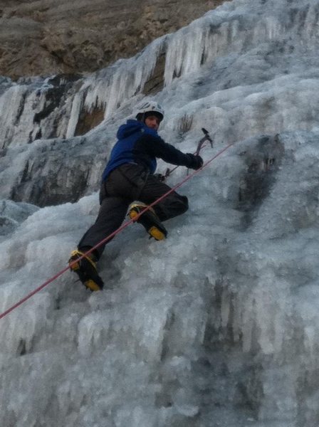
Great picture Michael.
First winter in Utah, cant wait for the ice.
Heading to Stairway to Heaven on Friday, good to see its climbable.
Also, I only have one season of ice climbing under my belt from Georgia (dont laugh), how much of Stairway to Heaven is top rope-able and are there anchors? Or do you need to lead it, build an anchor then start top roping?
|
|
|
Michael Davidson
·
Nov 9, 2011
·
North Bend, WA
· Joined Apr 2010
· Points: 141
Kyle Gochenour wrote:Great picture Michael. First winter in Utah, cant wait for the ice. Heading to Stairway to Heaven on Friday, good to see its climbable. Also, I only have one season of ice climbing under my belt from Georgia (dont laugh), how much of Stairway to Heaven is top rope-able and are there anchors? Or do you need to lead it, build an anchor then start top roping? The Apron, a wide fan of ice which forms at the bottom is easily top-roped by walking across a relatively wide shelf (~7 feet) to chain anchors (held away from the wall which gets covered in ice by piping) or screws you place in the plentiful ice. Be careful traversing to the anchors, though as its easy to see how someone might be lured into taking it too easily. We're gonna be up there again tomorrow (Thursday morning) around 8, for anyone who wants to join in on the top roping fun. I suspect most folks have work or class, though.
|
|
|
Michael Davidson
·
Nov 10, 2011
·
North Bend, WA
· Joined Apr 2010
· Points: 141
Scratch that. Not going up tomorrow AM.
|
|
|
Matt Jesperson
·
Nov 11, 2011
·
Unknown Hometown
· Joined Nov 2007
· Points: 140
Robert's Horn ice, 11/10/11. Still thin for our taste, but getting there. Climbed around on the large moat.
|
|
|
Kyle Gochenour
·
Nov 11, 2011
·
Unknown Hometown
· Joined Nov 2011
· Points: 0
Thanks everyone for all the Stairway to Heaven beta. It was a great climb today on the Apron. Ice was in a little more than Michaels pictures from earlier this week.
There was another group up there too, not sure if they were anyone here, but they mentioned Mountain Project.
I was really impressed with the climb, the ice was nice and sticky and you didnt get too wet. But it was really flowing in spots. There was a lot more rockfall than I would have liked but I guess that comes with the territory. Its going to be a great winter for sure!
|

 Continue with onX Maps
 Continue with Facebook