
 Continue with onX Maps


All Locations >
California
> Yosemite NP
> Tuolumne Meadows
> Cathedral Range
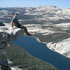
> Tenaya Peak
> Northwest Buttress (5.5 4b 13 IV+ 11 MS 4a)


ID 110950625 ·
·
Copyright Violation?


Rate Photo

 4.0
from
3 votes
4.0
from
3 votes
Sean
Aug 28, 2015
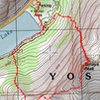
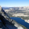
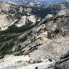
“The "open bouldery area" referenced in Supertopo, marked by a big cairn, to drop down and out onto the frontside talus slope facing the lake, to connect to the frontside ledge traverse descent option. This spot is about 20-30 mins below the true summit, after passing the second and bigger rock formation along the way down the ridgeline. Aug 2015.”


1 Comment