
 Continue with onX Maps
 Continue with Facebook


The Icebox Rock Climbing
Routes in The Icebox

|
A Hard Rain's Gonna Fall S 5.10d 6b+ 21 VII+ 21 E3 5b |

|
Bob, The Roofer T 5.11d 7a 24 VIII 25 E5 6a |
|
|
Brain Freeze S 5.10d 6b+ 21 VII+ 21 E3 5b |
|
|
Corneal Abrasion S 5.6 4c 14 V 12 S 4b |
|
|
Disney on Ice S 5.11b 6c 23 VIII- 23 E3 5c |
|
|
Friction Fix T,S 5.11b/c 6c+ 23 VIII- 24 E4 6a |
|
|
Frozen in Time S 5.12a 7a+ 25 VIII+ 25 E5 6a |
|
|
Hemisphere S 5.9+ 5c 17 VI 17 E1 5a |

|
Ice Age S 5.11b 6c 23 VIII- 23 E3 5c |
|
|
Ice, Ice, Baby S 5.12b 7b 26 VIII+ 26 E5 6b |
|
|
Iceboxer, The S 5.13 8a 29 X- 30 E7 6c |
|
|
Microfridge, The S 5.12b 7b 26 VIII+ 26 E5 6b |
|
|
Queen Byron S 5.11c 6c+ 24 VIII- 24 E4 6a |
|
|
Sub-Zero T 5.13- 7c+ 29 IX+ 29 E7 6c |
|
|
Tenth Avenue Freeze-Out S 5.11c 6c+ 24 VIII- 24 E4 6a |
|
|
Trads Are People, Too! T 5.9 5c 17 VI 17 HVS 5a |
|
|
Unknown Crack S 5.10c 6b 20 VII 20 E2 5b |
| Unsorted Routes: | |
Order Wrong?
Sort Routes
Use onX Backcountry to explore the terrain in 3D, view recent satellite imagery, and more. Now available in onX Backcountry Mobile apps! For more information see this post.
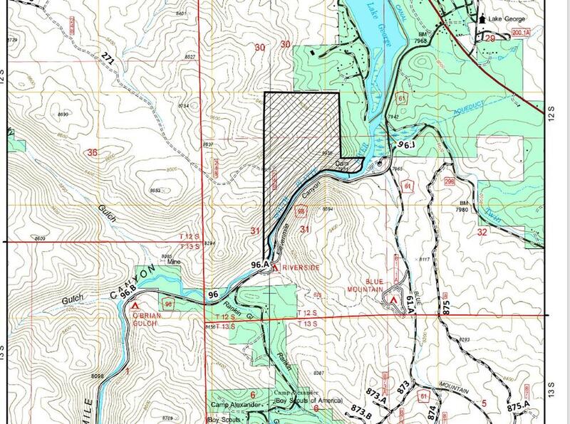
| Elevation: | 8,455 ft |
| GPS: |
38.90773, -105.46008 Google Map · Climbing Area Map |
| Page Views: | 29,679 total · 123/month |
| Shared By: | Ron Olsen on Jun 10, 2004 |
| Admins: | Leo Paik, John McNamee, Frances Fierst, Monty, Monomaniac, Tyler KC |
 Access Issue: Seasonal Raptor Closures January 1- July 31st, 2016-2021
Details
Access Issue: Seasonal Raptor Closures January 1- July 31st, 2016-2021
Details
For 2022: per Daniel Bryant: they did extend the order, but what I found was that the closed area does not encompass any of the common climbing areas within Elevenmile Canyon.
Seasonal Closures in effect January 1-July 31st, 2016-2021.
For details visit:
fs.usda.gov/Internet/FSE_DO…
Maps:
fs.usda.gov/Internet/FSE_DO…
fs.usda.gov/Internet/FSE_DO…
Contact phone number: (719) 553-1400.
Seasonal Closures in effect January 1-July 31st, 2016-2021.
For details visit:
fs.usda.gov/Internet/FSE_DO…
Maps:
fs.usda.gov/Internet/FSE_DO…
fs.usda.gov/Internet/FSE_DO…
Contact phone number: (719) 553-1400.
Classic Climbing Routes at The Icebox
Mountain Project's determination of the classic, most popular, highest rated climbing routes in this area.
Weather Averages
|
High
|
Low
|
|
Precip
|
Days w Precip
|
Prime Climbing Season
| J | F | M | A | M | J | J | A | S | O | N | D |
| J | F | M | A | M | J | J | A | S | O | N | D |


All Photos Within The Icebox
Most Popular · Newest · RandomMore About The Icebox
Printer-FriendlyWhat's New
Guidebooks (13)


4 Comments